Maps of Bronx County
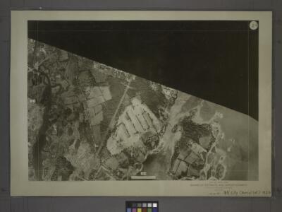
2D - N.Y. City (Aerial Set).
from Sectional aerial maps of the City of New York / [photographed and assembled under the direction of the chief engineer, July 1st, 1924].
Planning Grid of the Office of the Topographical Bureau of Bronx.
from Topographical survey sheets of the borough of the Bronx easterly of the Bronx River.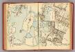
136-137 New Rochelle.
1 : 5400 G.W. Bromley & Co.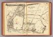
132-133 Pelham, New Rochelle.
1 : 5400 G.W. Bromley & Co.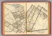
128-129 Pelham Manor.
1 : 5400 G.W. Bromley & Co.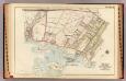
New Rochelle ward 2.
1 : 3600 Bromley, George Washington; Bromley, Walter Scott; G.W. Bromley & Co.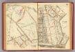
130-131 Pelham.
1 : 5400 G.W. Bromley & Co.
Planning Grid of the Office of the Topographical Bureau of Bronx.
from Topographical survey and new street system of the borough of the Bronx, easterly of the Bronx River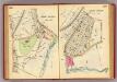
106-107 Mt. Vernon.
1 : 3600 G.W. Bromley & Co.
Area District Map Section No. 2
from Area district map / City of New York, Board of Estimate and Apportionment.
Sheet 29: Map of Pelham Bay Park, City of New York, forming sheet 29 of the Topographical Atlas of the Territory East of the Bronx River.
from Topographical survey and new street system of the borough of the Bronx, easterly of the Bronx River
Pelham, Pelham-Manor.
1 : 14400 Bromley, George Washington; Bromley, Walter Scott; G.W. Bromley & Co.
Height District Map Section No. 2; Height district map / City of New York, Board of Estimate and Apportionment.
from Height district map / City of New York, Board of Estimate and Apportionment. New York (N.Y.). Board of Estimate and Apportionment,
Use District Map Section No. 2; Use district map / City of New York, Board of Estimate and Apportionment.
from Use district map / City of New York, Board of Estimate and Apportionment. New York (N.Y.). Board of Estimate and Apportionment,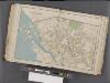
Westchester, Double Page Plate No. 14 [Map bounded by Pelham Winthrop St., Echo Ave., Long Island Sound] / prepared under the direction of Joseph R. Bien, from general surveys and official records.
From Atlas of Westchester County, New York
Plate 55 & 56: Part of New Rochelle, Westchester Co. N.Y.
from County atlas of Westchester, New York. Published by J.B. Beers & Co., assisted by S.W. Wilson and others.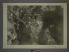
4B - N.Y. City (Aerial Set).
from Sectional aerial maps of the City of New York / [photographed and assembled under the direction of the chief engineer, July 1st, 1924].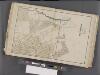
Westchester, Double Page Plate No. 9 [Map bounded by Pelham, Randal Ave., Mundys Lane, E. 5th St.] / prepared under the direction of Joseph R. Bien, from general surveys and official records.
From Atlas of Westchester County, New York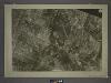
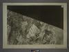
2C - N.Y. City (Aerial Set).
from Sectional aerial maps of the City of New York / [photographed and assembled under the direction of the chief engineer, July 1st, 1924].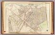
Pelham town, village.
1 : 3600 Bromley, George Washington; Bromley, Walter Scott; G.W. Bromley & Co.
Sheet 14: Grid #16000E - 20000E, #11000N - 15000N. [Includes Boston Post Road, (EastChester), Rattlesnake Creek, (Bay Chester Avenue) and Eastchester Landing Road.]
from Topographical survey sheets of the borough of the Bronx easterly of the Bronx River.
Sheet 27: Grid #20000E - 24000E, #7000N - 11000N. [Includes Goose Island, Givans Creek (Co-Op. City, Bay Plaza) and Pelham Bay Park.]
from Topographical survey sheets of the borough of the Bronx easterly of the Bronx River.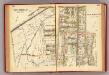
134-135 New Rochelle.
1 : 5400 G.W. Bromley & Co.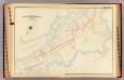
New Rochelle ward 1.
1 : 2400 Bromley, George Washington; Bromley, Walter Scott; G.W. Bromley & Co.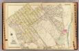
Mt. Vernon ward 1.
1 : 2400 Bromley, George Washington; Bromley, Walter Scott; G.W. Bromley & Co.
Sheet 15: Grid #16000E - 20000E, #7000N - 11000N. [Includes East Chester Road,(Gun Hill Road and Pelham Gardens), Black Dark Brook.]
from Topographical survey and new street system of the borough of the Bronx, easterly of the Bronx River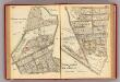
126-127 Pelham Manor, New Rochelle.
1 : 5400 G.W. Bromley & Co.
From New York to Stratford. (2)
1 : 35000 Colles, Christopher
Plates 53 & 54: Town of New Rochelle, Westchester Co. N.Y. - Town of Pelham, Westchester Co. N.Y. - City Island, Pelham Township, Westchester Co. N.Y.
from County atlas of Westchester, New York. Published by J.B. Beers & Co., assisted by S.W. Wilson and others.