Maps of Manhattan Community Board 9

Sackersdorff Farm set.
from Sackersdorf Farm Set.
Part of Ward 12, New York City.
from Atlas of the city of New York : embracing all territory within its corporate limits from official records, private plans & actual surveys / by and under the supervision of E. Robinson & R.H. Pidgeon, civil engineers.
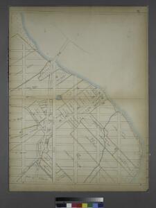
[Plate 41: Bounded by E. 136th Street, Harlem River, First Avenue, E. 125th Street, and Fifth Avenue.]
from Atlas of the city of New York, borough of Manhattan. From actual surveys and official plans / by George W. and Walter S. Bromley.
Part of Section 6: New York City.
from Atlas of the city of New York, Manhattan Island. From actual surveys and official plans / by George W. and Walter S. Bromley.
Manhattan, Double Page Plate No. 41 [Map bounded by Harlem River, E.125th St., 5th Ave.]
From Atlas of the city of New York, Manhattan Island. From actual surveys and official plans
Manhattan, Double Page Plate No. 33 [Map bounded by 3rd Ave., E. 125th St., East River, E. 108thSt.]
From Atlas of the city of New York, Manhattan Island. From actual surveys and official plans
Part of Section 6 : New York City.
from Atlas of the city of New York, borough of Manhattan. From actual surveys and official plans / by George W. and Walter S. Bromley.
Part of Section 6 : New York City.
from Atlas of the city of New York, Manhattan Island. From actual surveys and official plans / by George W. and Walter S. Bromley.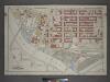
Plate 2: Part of Section 9, Borough of the Bronx. [Bounded by E. 138th Street, Third Avenue, E. 139th Street, Brook Avenue, E. 132nd Street, Lincoln Avenue, Southern Boulevard, Third Avenue, E. 135th Street and Exterior Street.]
from Atlas and owners names, borough of the Bronx, sections 9 & 10 : from actual surveys and official plans / by George W. and Walter S. Bromley.
28. Ward 12.
1 : 2400 G.W. Bromley & Co.; Geo. W. Bromley & E. Robinson
Pl. 33: ward 12
1 : 1800 Bromley, George Washington; Bromley, Walter Scott
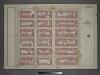
Plan of the extension of the Interborough Rapid Transit system (old Manhattan R. R. Co.) from 2nd Ave. across the Harlem River, with environs from 126th to 135th Sts.
From Manhattan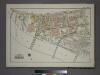
Plate 3, Part of Section 9, Borough of the Bronx. [Bounded by E. 135th Street, Willis Avenue, (Harlem River) Southern Boulevard and Park Avenue.]
from Atlas of borough of the Bronx, Sections 9 10 11 12 & 13 : from actual surveys and official plans / G.W. Bromley and Co.
24. Ward 12.
1 : 2400 G.W. Bromley & Co.; Geo. W. Bromley & E. Robinson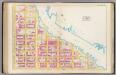
Pl. 41: ward 12.
1 : 1800 Bromley, George Washington; Bromley, Walter Scott
Plate 2: Map No. 419 [Bounded by 138th Street, Mill Brook, 131st Street, Morris Avenue, 130th Street, Harlem River High Water Line and Third Avenue.]
from Certified copies of important maps appertaining to the 23rd and 24th wards, City of New York, filed in the Register's office at White Plains, County of Westchester, New York ...
Manhattan, Double Page Plate No. 34 [Map bounded by Lenox Ave., E. 125th St., 3rd Ave., E. 108th St.]
From Atlas of the city of New York, Manhattan Island. From actual surveys and official plans
[Plate 34: Bounded by Lenox Avenue (6th Ave.), W. 125th Street, E. 125th Street, Third Avenue, E. 108th Street, and W. 110th Street.]
from Atlas of the city of New York, borough of Manhattan. From actual surveys and official plans / by George W. and Walter S. Bromley.
[Plate 34: Bounded by Lenox Avenue, W. 125th Street, Third Avenue, E. 108th Street, Fifth Avenue and (Central Park) W. 110th Street.]
from Atlas of the city of New York, Manhattan Island. From actual surveys and official plans / by George W. and Walter S. Bromley.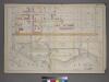
Plate 1: [Bounded by E. 137th Street, St. Anns Avenue, E. 132nd Street, Gouverneur Pl., E. 130th Street (Harlem River), Willis Avenue, E. 131st Street, Alexander Ave., E. 132nd St., and Lincoln Avenue.]
from Atlas of the city of New York : from official records, private plans & actual surveys / compiled under the supervision of E. Robinson & R. H. Pidgeon.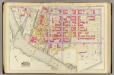
1, ward 23.
1 : 1800 Bromley, George Washington; Bromley, Walter Scott; G.W. Bromley & Co.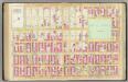
Pl. 34: ward 12.
1 : 1800 Bromley, George Washington; Bromley, Walter Scott
Part of Section 6: Plate 143
from Atlas of the borough of Manhattan, city of New York.
Part of Section 6: Plate 148
from Atlas of the borough of Manhattan, city of New York.
Plate 147: Bounded by W. 133rd Street, E. 133rd Street, Park Avenue, E. 127th Street, W. 127th Street and Lenox Avenue.
from Atlas of the borough of Manhattan, city of New York.
Part of Section 6: Plate 136
from Atlas of the borough of Manhattan, city of New York.
[Plate 142: Bounded by E. 127th Street, Second Avenue, E. 122nd Street and Park Avenue.]
from Atlas of the borough of Manhattan, city of New York.
Plate 130: Bounded by E. 116th Street, SecondAvenue, E. 110th Street and Park Avenue.
from Atlas of the borough of Manhattan, city of New York.
Part of Section 6: Plate 137
from Atlas of the borough of Manhattan, city of New York.