Maps of Queens County

[Plate 142: Bounded by E. 127th Street, Second Avenue, E. 122nd Street and Park Avenue.]
from Atlas of the borough of Manhattan, city of New York.
Manhattan, V. 8, Double Page Plate No. 177 [Map bounded by 3rd Ave., Harlem River, 1st Ave., E. 124th St.]
From Atlas 122. Vol. 8, 1896.
Manhattan, V. 8, Double Page Plate No. 174 [Map bounded by E. 125th St., 3rd Ave., E. 120th St., Portion of Mount Morris Sq., 5th Ave.]
From Atlas 122. Vol. 8, 1896.
Manhattan, V. 8, Double Page Plate No. 175 [Map bounded by 3rd Ave., E. 124th St., 1st Ave., E. 117th St.]
From Atlas 122. Vol. 8, 1896.
Manhattan, V. 8, Double Page Plate No. 178 [Map bounded by E. 130th St., 3rd Ave., E. 125th St., 5th Ave.]
From Atlas 122. Vol. 8, 1896.
[Plate 41: Bounded by E. 136th Street, Harlem River, First Avenue, E. 125th Street, and Fifth Avenue.]
from Atlas of the city of New York, borough of Manhattan. From actual surveys and official plans / by George W. and Walter S. Bromley.
Part of Section 6: New York City.
from Atlas of the city of New York, Manhattan Island. From actual surveys and official plans / by George W. and Walter S. Bromley.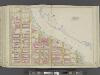
Manhattan, Double Page Plate No. 41 [Map bounded by Harlem River, E.125th St., 5th Ave.]
From Atlas of the city of New York, Manhattan Island. From actual surveys and official plans
28. Ward 12.
1 : 2400 G.W. Bromley & Co.; Geo. W. Bromley & E. Robinson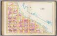
Pl. 41: ward 12.
1 : 1800 Bromley, George Washington; Bromley, Walter Scott
Plan of the extension of the Interborough Rapid Transit system (old Manhattan R. R. Co.) from 2nd Ave. across the Harlem River, with environs from 126th to 135th Sts.
From Manhattan
Part of Section 6: Plate 148
from Atlas of the borough of Manhattan, city of New York.
Plate 11: Part of Section 6.
from Atlas of the city of New York, borough of Manhattan / from actual surveys and official plans by George W. and Walter S. Bromley.
Part of Section 6: Plate 136
from Atlas of the borough of Manhattan, city of New York.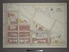
[Plate 23: Bounded by E. 133rd Street, (Harlem River) Lexington Avenue, E. 130th Street, Third Avenue, E. 129th Street, Second Avenue, E. 127th Street and Park Avenue.]
from Atlas of the city of New York, borough of Manhattan / from actual surveys and official plans by George W. and Walter S. Bromley.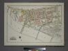
Plate 3, Part of Section 9, Borough of the Bronx. [Bounded by E. 135th Street, Willis Avenue, (Harlem River) Southern Boulevard and Park Avenue.]
from Atlas of borough of the Bronx, Sections 9 10 11 12 & 13 : from actual surveys and official plans / G.W. Bromley and Co.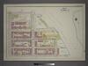
Plate 13: Part of Section 6.
from Atlas of the city of New York, borough of Manhattan / from actual surveys and official plans by George W. and Walter S. Bromley.
Part of Section 6: Plate 143
from Atlas of the borough of Manhattan, city of New York.
Part of Section 6: Plate 141
from Atlas of the borough of Manhattan, city of New York.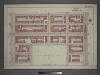
Plate 15: Part of Section 6.
from Atlas of the city of New York, borough of Manhattan / from actual surveys and official plans by George W. and Walter S. Bromley.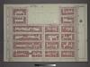
Plat 10: Part of Section 6.
from Atlas of the city of New York, borough of Manhattan / from actual surveys and official plans by George W. and Walter S. Bromley.
Plate 135: Bounded by W. 122nd Street, (Mount Morris Park) E. 122nd Street, Park Avenue, E. 116th Street, W. 116th Street and Lenox Avenue.
from Atlas of the borough of Manhattan, city of New York.
Part of Section 6: Plate 137
from Atlas of the borough of Manhattan, city of New York.
Plate 147: Bounded by W. 133rd Street, E. 133rd Street, Park Avenue, E. 127th Street, W. 127th Street and Lenox Avenue.
from Atlas of the borough of Manhattan, city of New York.
Manhattan, V. 8, Double Page Plate No. 173 [Map bounded by E. 120th St., 3rd Ave., E. 115th St., 5th Ave.]
From Atlas 122. Vol. 8, 1896.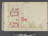
Manhattan, V. 7, Double Page Plate No. 29 [Map bounded by E. 134th St., Harlem River, E. 130th St., Madison Ave.] / compiled from official records and actual surveys under the direction of E. Robinson and Roger H. Pidgeon.
From Vol. 7
Plate 12: Part of Section 6.
from Atlas of the city of New York, borough of Manhattan / from actual surveys and official plans by George W. and Walter S. Bromley.
Manhattan, V. 8, Double Page Plate No. 176 [Map bounded by 1st Ave., E. 126th St., Harlem River, E. 118th St.]
From Atlas 122. Vol. 8, 1896.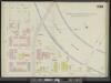
Manhattan, V. 11, Double Page Plate No. 239 [Map bounded by E. 135th St., 3rd Ave., E. 130th St., Madison Ave.]
From Atlas 42.61. Vol. 11-11 1/2, 1893.
![[Plate 142: Bounded by E. 127th Street, Second Avenue, E. 122nd Street and Park Avenue.]](https://images-2.georeferencer.com/images/iiif/150423064719/full/,300/0/native.jpg)

