Maps of Queens County

24. Ward 12.
1 : 2400 G.W. Bromley & Co.; Geo. W. Bromley & E. Robinson
Pl. 33: ward 12
1 : 1800 Bromley, George Washington; Bromley, Walter Scott
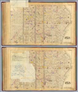
Manhattan, Double Page Plate No. 34 [Map bounded by Lenox Ave., E. 125th St., 3rd Ave., E. 108th St.]
From Atlas of the city of New York, Manhattan Island. From actual surveys and official plans
[Plate 34: Bounded by Lenox Avenue (6th Ave.), W. 125th Street, E. 125th Street, Third Avenue, E. 108th Street, and W. 110th Street.]
from Atlas of the city of New York, borough of Manhattan. From actual surveys and official plans / by George W. and Walter S. Bromley.
[Plate 34: Bounded by Lenox Avenue, W. 125th Street, Third Avenue, E. 108th Street, Fifth Avenue and (Central Park) W. 110th Street.]
from Atlas of the city of New York, Manhattan Island. From actual surveys and official plans / by George W. and Walter S. Bromley.
Pl. 34: ward 12.
1 : 1800 Bromley, George Washington; Bromley, Walter Scott
Manhattan, Double Page Plate No. 33 [Map bounded by 3rd Ave., E. 125th St., East River, E. 108thSt.]
From Atlas of the city of New York, Manhattan Island. From actual surveys and official plans
Part of Section 6 : New York City.
from Atlas of the city of New York, borough of Manhattan. From actual surveys and official plans / by George W. and Walter S. Bromley.
Part of Section 6 : New York City.
from Atlas of the city of New York, Manhattan Island. From actual surveys and official plans / by George W. and Walter S. Bromley.
Plate 130: Bounded by E. 116th Street, SecondAvenue, E. 110th Street and Park Avenue.
from Atlas of the borough of Manhattan, city of New York.
Plate 2: Part of Section 6.
from Atlas of the city of New York, borough of Manhattan / from actual surveys and official plans by George W. and Walter S. Bromley.
Part of Section 6: Plate 136
from Atlas of the borough of Manhattan, city of New York.
Plate 11: Part of Section 6.
from Atlas of the city of New York, borough of Manhattan / from actual surveys and official plans by George W. and Walter S. Bromley.
Part of Section 6: Plate 137
from Atlas of the borough of Manhattan, city of New York.
Part of Section 7: Plate 129
from Atlas of the borough of Manhattan, city of New York.
Plate 12: Part of Section 6.
from Atlas of the city of New York, borough of Manhattan / from actual surveys and official plans by George W. and Walter S. Bromley.
Plate 3: Section 6
from Atlas of the city of New York, borough of Manhattan / from actual surveys and official plans by George W. and Walter S. Bromley.
Plate 1: Part of Section 6.
from Atlas of the city of New York, borough of Manhattan / from actual surveys and official plans by George W. and Walter S. Bromley.
Plate 39, Part of Section 6: [Bounded by E. 110th Street, Third Avenue, E. 105th Street and Fifth Avenue.]
from Atlas of the city of New York, borough of Manhattan. From actual surveys and official plans / by George W. and Walter S. Bromley.
Plate 39, Part of Section 6: [Bounded by E. 110th Street, Third Avenue, E. 105th Street and Fifth Avenue.]
from Atlas of the city of New York, borough of Manhattan. From actual surveys and official plans / by George W. and Walter S. Bromley.
[Plate 124: Bounded by E. 110th Street, Third Avenue, E. 105th Street and (Central Park) Fifth Avenue.]
from Atlas of the borough of Manhattan, city of New York.
Plate 135: Bounded by W. 122nd Street, (Mount Morris Park) E. 122nd Street, Park Avenue, E. 116th Street, W. 116th Street and Lenox Avenue.
from Atlas of the borough of Manhattan, city of New York.
Manhattan, V. 8, Double Page Plate No. 173 [Map bounded by E. 120th St., 3rd Ave., E. 115th St., 5th Ave.]
From Atlas 122. Vol. 8, 1896.
Manhattan, V. 8, Double Page Plate No. 172 [Map bounded by E. 115th St., 3rd Ave., E. 110th St., 5th Ave.]
From Atlas 122. Vol. 8, 1896.
Manhattan, V. 8, Double Page Plate No. 175 [Map bounded by 3rd Ave., E. 124th St., 1st Ave., E. 117th St.]
From Atlas 122. Vol. 8, 1896.
Manhattan, V. 8, Double Page Plate No. 171 [Map bounded by 3rd Ave., E. 117th St., 1st Ave., E. 110th St.]
From Atlas 122. Vol. 8, 1896.
Part of Section 6: Plate 131
from Atlas of the borough of Manhattan, city of New York.
Manhattan, V. 8, Double Page Plate No. 168 [Map bounded by E. 110th St., 3rd Ave., E. 105th St., 5th Ave.]
From Atlas 122. Vol. 8, 1896.
Manhattan, V. 8, Double Page Plate No. 170 [Map bounded by 1st Ave., E. 118th St., Harlem River, E. 110th St.]
From Atlas 122. Vol. 8, 1896.