Maps of Richmond County
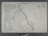
Sheet No. 34. [Includes Belair Road, Hope Avenue, Evelyn Place, St.Johns's Avenue, Shore Acres and Fort Wadsworth.]; Borough of Richmond, Topographical Survey.
from Borough of Richmond, Topographical Survey. Staten Island. Topographical Bureau.,
Borough of Richmond, Topographical Survey.
from Borough of Richmond, Topographical Survey.
Brooklyn, Vol. 6, Double Page Plate No. 28; Part of Ward 30, Section 18; [Map bounded by 83rd St., Ridge Blvd., 91st St., Bay Ridge Parkway]
from Ward 30.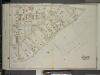
Brooklyn, Vol. 6, Double Page Plate No. 29; Part of Ward 30, Section 18; [Map bounded by 3rd Ave., Bay Ridge Parkway; Including 91st St.]
from Ward 30.
Plan of Bay Ridge parkway.
From Brooklyn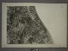
21D - N.Y. City (Aerial Set).
from Sectional aerial maps of the City of New York / [photographed and assembled under the direction of the chief engineer, July 1st, 1924].
Part of the Town of New Utrecht, Kings Co., N.Y.
from Robinson's atlas of Kings County, New York : compiled from official records ... / under the direction of E. Robinson.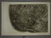
22C - N.Y. City (Aerial Set).
from Sectional aerial maps of the City of New York / [photographed and assembled under the direction of the chief engineer, July 1st, 1924].
Double Page Plate No. 19: [Bounded by 92nd Street, Third Avenue, 91st Street, Fifth Avenue, 86th Street, Fort Hamilton Avenue (Smith Avenue) and (Proposed Bay Ridge Parkway) Narrows Avenue.]
from Atlas of the Brooklyn borough of the City of New York : originally Kings Co.; complete in three volumes ... based upon official maps and plans ... / by and under the supervision of Hugo Ullitz, C.E.
Part of Ward 30, Land Map Section, No. 18. Volume 2, Brooklyn Borough, New York City.
from Atlas of the Brooklyn borough of the City of New York : originally Kings Co.; complete in three volumes ... based upon official maps and plans ... / by and under the supervision of Hugo Ullitz, C.E.
Map of a farm at Fort Hamilton in the town of New Utrecht.
from Brooklyn
Plate 8: [Bounded by Mackay Place, Narrows Avenue, 71st Street, First Avenue, 72nd Street, Second Avenue, 73rd Street, Third Avenue, 74th Street, Fourth Avenue, 75th Street, Stewart Avenue, 89th Street, Third Avenue, 87th Street, First Avenue, 86th Stree
from Robinson's atlas of Kings County, New York : compiled from official records ... / under the direction of E. Robinson.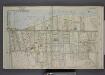
Part of Ward 4. [Map bound by Pier Line, New York Ave, Lyman Ave, Fingerboard Road, Fletcher St, Oak St, Fox Hill Golf Links, Vanderbilt Ave]
from Atlas of the borough of Richmond, city of New York.
Fort Hamilton. Town of New Utrecht, Kings Co. L.I.
from Atlas of Long Island, New York. From recent and actual surveys and records.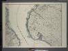
General map of the borough of Richmond (Staten Island) in the city of New York : showing in addition to the existing topographical features of the borough a tentative and preliminary plan for a street system of the same.
from Staten Island
Map of the Marine Hospital ground, Staten Island / reduced from a survey, made by John Ewen, dated March 1845 by Daniel Ewen, city surveyor.
from Staten Island
South Brooklyn, Park Slope, Brooklyn heights, Cobble Hill, Boerum Hill, Carroll Gardens, Red Hook, Gowanus, Windsor Terrace. (cont.)
From District 6
Map of the City of Brooklyn as consolidated by an act of the Legislature of the Ste of New York . . . Constructed from the official maps of the Commissioners . . . Exhibiting the farm lines names of the original owners.
From Brooklyn
Bath, Town on New Utrecht, Kings Co.
from Atlas of Long Island, New York. From recent and actual surveys and records.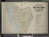
Index to Volume One, Atlas of the Borough of Brooklyn Sections 1, 2, 3 & 4. Wards 1, 2, 3, 4, 5, 6, 8, 9, 10, 12 & 22. City of New York. Published by E. Belcher Hyde, 97 Liberty St., Brooklyn. 1903.
from Wards 1, 2, 3, 4, 5, 6, 8, 9, 10, 12 & 22.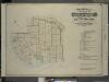
Index to Volume Six. Atlas of the Borough of Brooklyn. Sections 17, 18 & 19. Ward 30. City of New York. E. Belcher Hyde, 97 Liberty St., Brooklyn Borough. 1905.
from Ward 30.
Map of Staten Island o Richmond County. 16 views of buildings on border. Also view of Elliottville the property of Dr. S. M. Elliott.
From Staten Island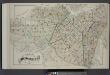
Index Map of Brooklyn
from Detailed estate and old farm line atlas of the city of Brooklyn : complete in six volumes ... from official records, private plans, and actual surveys ... / by G.M. Hopkins, C.E.
Map of Staten Island, Richmond County, New York City, from surveys under the direction of H. F. Walling.
From Staten Island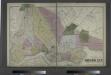
The City of Brooklyn.
from Atlas of Long Island, New York. From recent and actual surveys and records.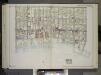
Brooklyn, Vol. 2, Double Page Plate No. 27; Part of Wards 30 & 31, Section 19; [Map bounded by 86th St., 23rd Ave., 24th Ave.; Including Gravesend Bay, 17th Ave.] / by and under the direction of Hugo Ullitz.
From Volume 2.
Index Map to Volume Two. Atlas of the Brooklyn Borough of the City of New York.
from Atlas of the Brooklyn borough of the City of New York : originally Kings Co.; complete in three volumes ... based upon official maps and plans ... / by and under the supervision of Hugo Ullitz, C.E.
[Four maps showing the distribution of the population by nationality of mothers.]
From Manhattan
Brooklyn.
1 : 31000 Rand McNally and Company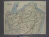
![Sheet No. 34. [Includes Belair Road, Hope Avenue, Evelyn Place, St.Johns's Avenue, Shore Acres and Fort Wadsworth.]; Borough of Richmond, Topographical Survey.](https://images-2.georeferencer.com/images/iiif/299299067817/full/,300/0/native.jpg)

