Maps of Kings County

Double Page Plate No. 19: [Bounded by 92nd Street, Third Avenue, 91st Street, Fifth Avenue, 86th Street, Fort Hamilton Avenue (Smith Avenue) and (Proposed Bay Ridge Parkway) Narrows Avenue.]
from Atlas of the Brooklyn borough of the City of New York : originally Kings Co.; complete in three volumes ... based upon official maps and plans ... / by and under the supervision of Hugo Ullitz, C.E.
Map of a farm at Fort Hamilton in the town of New Utrecht.
from Brooklyn
Fort Hamilton. Town of New Utrecht, Kings Co. L.I.
from Atlas of Long Island, New York. From recent and actual surveys and records.
Part of Ward 30, Land Map Section, No. 18. Volume 2, Brooklyn Borough, New York City.
from Atlas of the Brooklyn borough of the City of New York : originally Kings Co.; complete in three volumes ... based upon official maps and plans ... / by and under the supervision of Hugo Ullitz, C.E.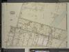
Brooklyn, Vol. 6, Double Page Plate No. 30; Part of Ward 30, Section 18; [Map bounded by Battery Ave., Fort Hamilton Ave., Bay Ridge Parkway; Including 3rd Ave., 91st St., 5th Ave., 92nd St.]; Sub Plan; [Map bounded by Fort Hamilton Ave., Bay
from Ward 30.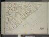
Brooklyn, Vol. 6, Double Page Plate No. 29; Part of Ward 30, Section 18; [Map bounded by 3rd Ave., Bay Ridge Parkway; Including 91st St.]
from Ward 30.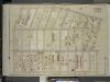
Brooklyn, Vol. 6, Double Page Plate No. 26; Part of Ward 30, Section 18; [Map bounded by 5th Ave., 91st St.; Including Ridge Blvd., 80th St.]
from Ward 30.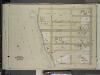
Brooklyn, Vol. 6, Double Page Plate No. 28; Part of Ward 30, Section 18; [Map bounded by 83rd St., Ridge Blvd., 91st St., Bay Ridge Parkway]
from Ward 30.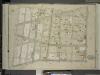
Brooklyn, Vol. 6, Double Page Plate No. 25; Part of Ward 30, Section 18; [Map bounded by 10th Ave., 92nd St.; Including 5th Ave., 81st St.]
from Ward 30.
Brooklyn Vol. A Plate No. 12 [Map bounded by 92nd St., 93rd St., 94th St., 95th St.; Including 2nd Ave., 3rd Ave., 4th Ave.]
From Atlas 61. Vol. A, 1893.
Part of the Town of New Utrecht, Kings Co., N.Y.
from Robinson's atlas of Kings County, New York : compiled from official records ... / under the direction of E. Robinson.
Plan of Bay Ridge parkway.
From Brooklyn
22C - N.Y. City (Aerial Set).
from Sectional aerial maps of the City of New York / [photographed and assembled under the direction of the chief engineer, July 1st, 1924].
Double Page Plate No. 23: [Bounded by (U.S. Government Reservation) Fort Hamilton Avenue, 86th Street, Bay 2nd Street, Benson Avenue, Delaplaine Street, Atlantic Avenue, (Dyker Beach Park) Seventh Avenue, 170th Street, Battery Avenue, Cropsey Avenue, Dah
from Atlas of the Brooklyn borough of the City of New York : originally Kings Co.; complete in three volumes ... based upon official maps and plans ... / by and under the supervision of Hugo Ullitz, C.E.
Plate 8: [Bounded by Mackay Place, Narrows Avenue, 71st Street, First Avenue, 72nd Street, Second Avenue, 73rd Street, Third Avenue, 74th Street, Fourth Avenue, 75th Street, Stewart Avenue, 89th Street, Third Avenue, 87th Street, First Avenue, 86th Stree
from Robinson's atlas of Kings County, New York : compiled from official records ... / under the direction of E. Robinson.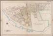
Plate 10: [Bounded by 85th Street, 1st Avenue, 86th Street, 2nd Avenue, 87th Street, 3rd Avenue., 88th Street, 5th Avenue, 86th Street, New Utrecht Avenue, Atlantic Avenue, (Dyker Beach Park) 7th Avenue, Warehouse Avenue, Cropsey Avenue, Dahlgreen Place, 92nd Street, ((Fort Hamilton) Fort Hamilton Avenue, Denyse Street, 5th Avenue and Bay Ridge Parkway.]; Atlas of the borough of Brooklyn, city of New York: from actual surveys and official plans by George W. and Walter S. Bromley.
from Atlas of the borough of Brooklyn, city of New York : from actual surveys and official plans by George W. and Walter S. Bromley. G.W. Bromley & Co.,
Plate 10: [Bounded by 72nd Street, Fourteenth Avenue, 86th Street and Stewart Avenue.]
from Robinson's atlas of Kings County, New York : compiled from official records ... / under the direction of E. Robinson.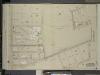
Brooklyn, Vol. 6, Double Page Plate No. 31; Part of Ward 30, Sections 18 & 19; [Map bounded by Bay Second St., Warehouse Ave., Battery Ave.; Including 102nd St., 7th Ave., 86th St.]; Sub Plan; [Map bounded by 7th Ave., 102nd St., Battery Ave
from Ward 30.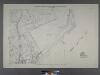
Sheet No. 42. [Includes South Beach and Lower New York Bay, McFarland Avenue, Cedar Avenue and Jackson Avenue in Arrochar.]; Borough of Richmond, Topographical Survey.
from Borough of Richmond, Topographical Survey. Staten Island. Topographical Bureau.,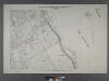
Sheet No. 34. [Includes Belair Road, Hope Avenue, Evelyn Place, St.Johns's Avenue, Shore Acres and Fort Wadsworth.]; Borough of Richmond, Topographical Survey.
from Borough of Richmond, Topographical Survey. Staten Island. Topographical Bureau.,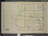
Brooklyn, Vol. 6, Double Page Plate No. 27; Part of Ward 30, Section 18; [Map bounded by 75th St., Ridge Blvd.; Including 83rd St., Bay Ridge Parkway]
from Ward 30.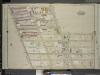
Brooklyn, Vol. 6, Double Page Plate No. 15; Part of Ward 30, Section 18; [Map bounded by 72nd St., 7th Ave.; Including 10th Ave., 81st St., 5th Ave.]
from Ward 30.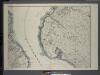
General map of the borough of Richmond (Staten Island) in the city of New York : showing in addition to the existing topographical features of the borough a tentative and preliminary plan for a street system of the same.
from Staten Island
Area District Map Section No. 22; Area district map / City of New York, Board of Estimate and Apportionment.
from Area district map / City of New York, Board of Estimate and Apportionment. New York (N.Y.). Board of Estimate and Apportionment,
Use District Map Section No. 22; Use district map / City of New York, Board of Estimate and Apportionment.
from Use district map / City of New York, Board of Estimate and Apportionment. New York (N.Y.). Board of Estimate and Apportionment,
Height District Map Section No. 22; Height district map / City of New York, Board of Estimate and Apportionment.
from Height district map / City of New York, Board of Estimate and Apportionment. New York (N.Y.). Board of Estimate and Apportionment,
Map of sewer district of Bath Beach and Bensonhurst-by-the-sea.
From Brooklyn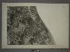
21D - N.Y. City (Aerial Set).
from Sectional aerial maps of the City of New York / [photographed and assembled under the direction of the chief engineer, July 1st, 1924].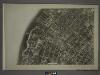
22A - N.Y. City (Aerial Set).
from Sectional aerial maps of the City of New York / [photographed and assembled under the direction of the chief engineer, July 1st, 1924].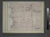
![Double Page Plate No. 19: [Bounded by 92nd Street, Third Avenue, 91st Street, Fifth Avenue, 86th Street, Fort Hamilton Avenue (Smith Avenue) and (Proposed Bay Ridge Parkway) Narrows Avenue.]](https://images-2.georeferencer.com/images/iiif/270353436400/full/,300/0/native.jpg)

