Maps of Mexico

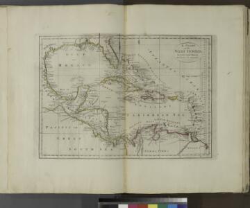
A chart of the West Indies, from the latest marine journals and surveys.
from Carey's general atlas, improved and enlarged : being a collection of maps of the world and quarters, their principal empires, kingdoms, &c.
Der Warme Meeresstrom des Atlantischen und der kalte Strom des Grossen Oceans in Parallele nach geographischer Lage und Ausdehnung dargestellt
Erster Band, enthaltend in vier Abtheilungen die Erscheinungen der anorganischen Natur: 1. Meteorologie und Klimatographie. 2. Hydrologie und Hydrographie. 3. Geologie. 4. Tellurischer Magnetismus Humboldt, Alexander von Verlag von Justus Perthes
Der Warme Meeresstrom Des Atlantischen.
1 : 30000000 Berghaus, Heinrich
Homannův atlas světa
1 : 6600000
America borealis
1 : 32500000 Severní Amerika Scherer, Heinrich
Facsimile: Part of America by Gussefeldt.
1 : 36000000 Gussefeldt, F.L.
Mexico, or, New Spain : divided into the audiance of Guadalayara, Mexico, and Guatimala, Florida.
from System of geography with new maps
A new and correct map of North America with the West India Islands : divided according to the last treaty of peace, concluded at Paris, 10th Feby. 1763 ; wherein are particularly distinguished, the several provinces and colonies, which compose the Britis
from Whole
The Western Ilands / by Rt. Morden.
from Geography rectified, or, A description of the world : in all its kingdoms, provinces, countries, islands, cities, towns, seas, rivers, bayes, capes, ports : their antient and present names, inhabitants, situations, histories, customs, governments, &c. : as also their commodities, coins, weights, and measures, compared with those at London : illustrated with above sixty new maps : the whole work performed according to the more accurate discoveries of modern authors / by Robert Morden.
Tabula geographica Mexicæ et Floridæ &c.
from Charts and maps
New Spain ; Guiana.
from A new systeme of the mathematicks: containing I. Arithmetick, as well natural and decimal, as in species, or the principles of algebra. II. Practical geometry, together with the first six books of Euclid's Elements, as also the eleventh and twelfth, symbo
Nordamerica
Neuester Schul-Atlas Walch, Johann im Verlag bei Joh. Walch
Stromgebiet von Nordamerica
Grosser Hand-Atlas über alle Theile der Erde in 170 Karten Meyer, J. Verlag des Bibliographischen Instituts
4. Atlas des ganzen Erdkreises.
1 : 60000000 Reichard, C. G.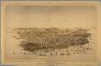
Birds eye view of the city of San Francisco.
From California
Messico, ouvero Nuova-Spagna : che contiene il Nuovo Messico, la California con una parte de paesi adjacenti / G. Pitteri scr.
from Mexico
A new and correct map of North America with the West India Islands : divided according to the last Treaty of Peace, concluded at Paris the 20th of Jan. 1783, wherein are particularly distinguished the thirteen provinces wich [sic] compose the United Stat
from Charts and maps
The unique map of California.
From California
Pascaerte van Westindien : de vaste kusten en de Eylanden.
from De zee-atlas, ofte, Water-weereld : waer in vertoont werden alle de zee-kusten van het bekende des aerd-bodems : seer dienstigh voor alle heeren en kooplieden, als oock voor alle schippers en stuurlieden / gesneden, gedruckt en uytgegeven t'Amsteldam.
New Map Of The Union.
1 : 6000000 Johnson, D. Griffing
Ethnographische Karte von Nordamerika
Zweiter Band, enthaltend in vier Abtheilungen die Vertheilung der Organismen: 5. Pflanzen-Geographie, 6. Thier-Geographie, 7. Anthropographie, 8. Ethnographie Humboldt, Alexander von Verlag von Justus Perthes
America Septentrionalis. [Karte], in: Novus atlas absolutissimus, Bd. 6, S. 197.
1 Karte aus Atlas Janssonius Offizin
A New map of North America with the West India Islands : divided according to the preliminary articles of peace, signed at Versailles, 20, Jan. 1783, wherein are particularly distinguished the United States, and the several provinces, governments &ca
from Whole
L'Amerique septentrionale
1 : 16000000 dressée sur les observations de Mrs. de l'Academie Royale des Sciences & quelques autres, & sur les memoires les plus recens [...] par G. de l'Isle A Amsterdam : chez J. Cóvens & C. Mortier
Map of the United States of America, the British provinces, Mexico, the West Indies and Central America, with part of New Granada and Venezuela / map drawn by Geo. W. Colton ; engraved by John M. Atwood ; border desig'd. & eng'd. by W. S. Barnard.
from Parts
XI. Basin of the North Atlantic Ocean
Maury, Matthew Fontaine
America septentrionalis
Severní Amerika Janssonius, Johannes excudit Ioannes Ianßonius
VI. Gulf stream and drift
Maury, Matthew Fontaine
Nord America
Hand-Atlas über alle Theile der Erde nach dem neuesten Zustande und über das Weltgebäude Stieler, Adolf bei Justus Perthes