Maps of Central Lowland

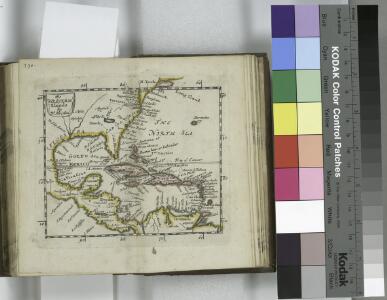
The Western Ilands / by Rt. Morden.
from Geography rectified, or, A description of the world : in all its kingdoms, provinces, countries, islands, cities, towns, seas, rivers, bayes, capes, ports : their antient and present names, inhabitants, situations, histories, customs, governments, &c. : as also their commodities, coins, weights, and measures, compared with those at London : illustrated with above sixty new maps : the whole work performed according to the more accurate discoveries of modern authors / by Robert Morden.
A new generall chart for the West Indies....
from English pilot. The fourth book.
Carte de l'Amérique septentrionale, 1755.
from Charts and maps
Carte marine de l'Amerique septentrionale et une partie de la B.e d'Hudson
1 Karte : Kupferdruck ; 41 x 48 cm Königliche Akademie der Wissenschaften
A new map or chart in Mercators projection, of the Western or Atlantic Ocean, with part of Europe, Africa and America
1 : 18000000
Mar Del Nort. [Karte], in: Novus atlas absolutissimus, Bd. 9, S. 58.
1 Karte aus Atlas Janssonius Offizin
Homannův atlas světa
1 : 6600000
New Jersey / engraved by J.H. Young.
from Whole
Mar Del Nort. [Karte], in: Het vijfde Deel Des Grooten Atlas : Vervatende De Water-Weereld, S. 56.
1 Karte aus Atlas Jansson, Jan Jansson, Jan
Mar del Nort / [Joannes Janssonius]
1 : 30000000 Annotatie: Origineel is Blad 3 in atlas factice Janssonius, Joannes (jr.) (1588-1664) [Amsterdam : Joannes Janssonius]
Part of Brookhaven Suffolk County
from Atlas of ... Suffolk County, Long Island, New York ... : based upon actual measurements by our own corps of engineers, maps on file at county offices, also maps from actual surveys furnished by individual owners / under the supervision of Merritt B. Hyde.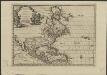
L'Amérique septentrionale, suivant les nouvelles observations de Messr. de l'Académie Royale des Sciences, etc : augmentées de nouveau
1 : 37000000 A Leide : chez Pierre vander Aa
Meteorological chart of the North Atlantic Ocean
1 : 13700000 Atlantský oceán (oblast) Secretary of Agriculture
Meteorological chart of the North Atlantic Ocean
1 : 13700000 Atlantský oceán (oblast) Secretary of Agriculture
Nord-Atlantischer Ocean
Handatlas über alle Theile der Erde und über das Weltgebäude Stieler, Adolf Justus Perthes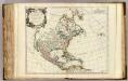
Amerique Septentrionale.
1 : 17400000 Robert de Vaugondy, Gilles, 1688-1766
Nord-Atlantischer Ocean
Hand-Atlas über alle Theile der Erde und über das Weltgebäude Stieler, Adolf Justus Perthes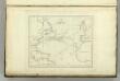
Chart of the Atlantic Ocean.
1 : 35000000 Melish, John
A new map or chart in Mercators projection of the Western or Atlantic Ocean: with part of Europe, Africa and America.
from Atlantic Ocean J. (John) Bew?: [London],
Amérique septentrionale dressée sur les relations les plus modernes des voyageurs et navigateurs ou se remarquent les Etats unis.
from John H. Levine Collection Publiée ... par le S. Robert de Vaugondy, géographe: [Paris?]; Robert de Vaugondy, Gilles,
Mar del nort
1 : 30000000
XI. Basin of the North Atlantic Ocean
Maury, Matthew Fontaine
A new map of North America shewing its principal divisions, chief cities, townes, rivers, mountains &c.
from Whole Printed by T.W. for R. Bonwicke, J. Walthoe, R. Wilkin, and T. Ward?: [London]; Burghers, M.; Wells, Edward,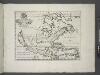
A new map of North America shewing its principal divisions, chief cities, townes, rivers, mountains & c. / delin. M. Burg.; sculpt. Univ. Oxon.; A new sett of maps both of antient and present geography: wherein not only the latitude and longitude of many places are corrected according to the latest observations, but also the most remarkable differences of antient and present geography may be quickly discern'd by a bare inspection or comparing of correspondent maps, which seems to be the most natural and easy method to lead young students (for whose use the work is principally intended) unto a competent knowledge of the geographical science: together with a geographical treatise particularly adapted to the use and design of these maps / by Edward Wells, M.A. and student of Christ-Church, Oxon.
from A new sett of maps both of antient and present geography : wherein not only the latitude and longitude of many places are corrected according to the latest observations, but also the most remarkable differences of antient and present geography may be quickly discern'd by a bare inspection or comparing of correspondent maps, which seems to be the most natural and easy method to lead young students (for whose use the work is principally intended) unto a competent knowledge of the geographical science : together with a geographical treatise particularly adapted to the use and design of these maps / by Edward Wells, M.A. and student of Christ-Church, Oxon. Wells, Edward; Sheldonian Theatre,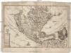
America borealis
1 : 32500000 Severní Amerika Scherer, Heinrich
VI. Gulf stream and drift
Maury, Matthew Fontaine
Chart of the Atlantic Ocean.
from The new American practical navigator; : being an epitome of navigation; containing all the tables necessary to be used with the Nautical Almanac, in determining the latitude; and the longitude by lunar observations; and keeping a complete reckoning at sea. ... : The whole exemplified in a journal, kept from Boston to Madeira, in which all the rules of navigation are introduced ... : To which are added, some general instructions and information ... relative to maritime laws and mercantile customs. / From the best authorities. ; enriched with a number of new tables, with original improvements and additions, and a large variety of new and important matter: also many thousand errors are corrected, which have appeared in the best systems of navigation yet published. ; By Nathaniel Bowditch, Fellow of the American Academy of Arts and Sciences. ; Illustrated with copperplates.
The English empire in America, Newfound-land, Canada, Hudsons Bay, &c. in plano / Herman Moll fecit.
from Atlas manuale, or, A new sett of maps of all the parts of the earth : as well Asia, Africa and America, as Europe : wherein geography is rectify'd, by reforming the old maps according to the modern observations : and the coasts of all countries are laid down, agreeable to Mr. Edmund Halley's own map ... / mostly performed by Herman Moll.
Chart Shewing (sic) the Communication between Europe, North America, and the Pacific.
1 : 14500000 Black, Adam & Charles