Maps of Hudson County

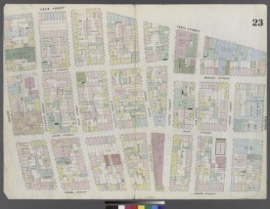
Plate 23: Map bounded by Broome Street, Bowery, Canal Street, Broadway
from Maps of the city of New York.
[Plate 23: Map bounded by Canal Street, Broadway, Broome Street, Bowery; Including Hester Street, Howard Street, Grand Street, Elizabeth Street, Mott Street, Mulberry Street, Baxter Street, Centre Market Place, Centre Street, Elm Street, C
from Maps of the city of New-York.
Plate 26: Map bounded by Broome Street, Bowery, Bayard Street, Orange Street, White Street, Centre Street.
from Maps of the city of New York / surveyed under directions of insurance companies of said city.
Manhattan, V. 1, Plate No. 23 [Map bounded by Broome St., Bowery, Canal St., Baxter St.]
From Atlas 107. Vol. 1, 1894.
Plate 30: Map bounded by Spring Street, Elm Street, Broome Street, Centre Street, Canal Street, Mercer Street.
from Maps of the city of New York / surveyed under directions of insurance companies of said city.
Manhattan, V. 1, Plate No. 23 west half [Map bounded by Broome St., Baxter St., Canal St., Broadway]
From Atlas 107. Vol. 1, 1894.
Part of Sections 1& 2: Plate18.
from Atlas of the borough of Manhattan, city of New York.
Plate 11, Part of Section 1: [Bounded by Grand Street, Mulberry Street, Baxter Street, Franklin Street and West Broadway.]
from Atlas of the city of New York, borough of Manhattan. From actual surveys and official plans / by George W. and Walter S. Bromley.
Part of Section 1 : Plate 11.
from Atlas of the borough of Manhattan, city of New York.
Plate 18, Part of Sections 1&2: [Bounded by Spring Street, Bowery Street, Delancey Street, Orchard Street, Hester Street, Mulberry Street, Grand Street, Centre Street and Marion Street.]
from Atlas of the city of New York, borough of Manhattan. From actual surveys and official plans / by George W. and Walter S. Bromley.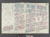
Manhattan, V. 1, Double Page Plate No. 24 [Map bounded by Broadway, E. Houston St., Bowery, Broome St., Elizabeth St.]
From Atlas 107. Vol. 1, 1894.
Part of Section 2 : Plate 20.
from Atlas of the borough of Manhattan, city of New York.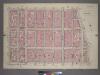
Plate 20, Part of Section 2: [Bounded by Prince Street, Marion Street, Centre Street, Grand Street and Sullivan Street.]
from Atlas of the city of New York, borough of Manhattan. From actual surveys and official plans / by George W. and Walter S. Bromley.
Plate 12: Bounded by Hester Street, Orchard Street, Division Street, Pike Street, East Broadway, Chatham Square, Bowery Street, Bayard Street and Mulberry Street.
from Atlas of the borough of Manhattan, city of New York.
Plate 12, Part of Section 1: [Bounded by Hester Street, Orchard Street, Division Street, Pike Street, East Broadway, Chatham Square, Bowery Street, Bayard Street and Mulberry Street.]
from Atlas of the city of New York, borough of Manhattan. From actual surveys and official plans / by George W. and Walter S. Bromley.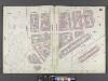
Manhattan, V. 1, Double Page Plate No. 13 [Map bounded by Canal St., East Broadway, Market St., Park Row, Milberry St., Park St., Mott St.]
From Atlas 107. Vol. 1, 1894.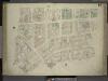
[Plate 14: Map bounded by Elm Street, Canal Street, Mott Street, Park Street, Mulberry Street, Chatham Street, Pearl Street; Including Centre Street, Park Street, Mission Place, Baxter Street, Mulberry Street, Worth Street, Leonard Stree
from Maps of the city of New-York.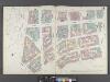
Manhattan, V. 1, Double Page Plate No. 14 [Map bounded by Elm St., Canal St., Mott St., Park Row, Pearl St.]
From Atlas 107. Vol. 1, 1894.
Plate 29: Map bounded by Canal Street, Centre Street, Leonard Street, West Broadway.
from Maps of the city of New York / surveyed under directions of insurance companies of said city.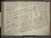
[Plate 24: Map bounded by Crosby Street, E.Houston Street, Bowery, Broome Street; Including Elm Street, Marion Street, Mulberry Street, Mott Street, Elizabeth Street, Spring Street, Prince Street]
from Maps of the city of New-York.
[Plate 14: Map bounded by Canal Street, Mott Street, Cross Street, Mulberry Street, Chatham Street, Pearl Street, Elm Street]
from Maps of the city of New York.
Plate 24: Map bounded by Houston Street, Bowery, Broome Street, Crosby Street
from Maps of the city of New York.
Plate 24: Map bounded by Bowery, Rivington Street, Allen Street, Grand Street.
from Maps of the city of New York / surveyed under directions of insurance companies of said city.
Plate 25: Map bounded by Rivington Street, Ludlow Street, Canal Street, Bowery
from Maps of the city of New York.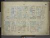
[Plate 15: Map bounded by Church Street, Canal Street, Elm Street, Pearl Street; Including Franklyn Place, Broadway, Benson Street, Courtlandt Alley, Worth Street, Leonard Street, Franklin Street, White Street, Walker Street, Lispenard St
from Maps of the city of New-York.
[Plate 15: Map bounded by Canal Street, Elm Street, Pearl street, Church Street]
from Maps of the city of New York.
Plate 31: Map bounded by Spring Street, Mercer Street, Canal Street, Laurens Street.
from Maps of the city of New York / surveyed under directions of insurance companies of said city.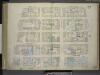
[Plate 22: Map bounded by Thompson Street, Spring Street, Broadway, Canal Street; Including Laurens Street, Wooster Street, Greene Street, Mercer Street, Grand Street, Broome Street]
from Maps of the city of New-York.
Manhattan, V. 1, Plate No. 15 [Map bounded by Church St., Canal St., Elm St., Franklin St.]
From Atlas 107. Vol. 1, 1894.