Maps of Hudson County

Manhattan, V. 1, Plate No. 23 west half [Map bounded by Broome St., Baxter St., Canal St., Broadway]
From Atlas 107. Vol. 1, 1894.
Plate 30: Map bounded by Spring Street, Elm Street, Broome Street, Centre Street, Canal Street, Mercer Street.
from Maps of the city of New York / surveyed under directions of insurance companies of said city.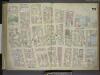
[Plate 23: Map bounded by Canal Street, Broadway, Broome Street, Bowery; Including Hester Street, Howard Street, Grand Street, Elizabeth Street, Mott Street, Mulberry Street, Baxter Street, Centre Market Place, Centre Street, Elm Street, C
from Maps of the city of New-York.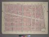
Plate 11, Part of Section 1: [Bounded by Grand Street, Mulberry Street, Baxter Street, Franklin Street and West Broadway.]
from Atlas of the city of New York, borough of Manhattan. From actual surveys and official plans / by George W. and Walter S. Bromley.
Part of Section 1 : Plate 11.
from Atlas of the borough of Manhattan, city of New York.
Plate 23: Map bounded by Broome Street, Bowery, Canal Street, Broadway
from Maps of the city of New York.
Plate 26: Map bounded by Broome Street, Bowery, Bayard Street, Orange Street, White Street, Centre Street.
from Maps of the city of New York / surveyed under directions of insurance companies of said city.
Plate 29: Map bounded by Canal Street, Centre Street, Leonard Street, West Broadway.
from Maps of the city of New York / surveyed under directions of insurance companies of said city.
Plate 31: Map bounded by Spring Street, Mercer Street, Canal Street, Laurens Street.
from Maps of the city of New York / surveyed under directions of insurance companies of said city.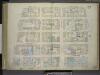
[Plate 22: Map bounded by Thompson Street, Spring Street, Broadway, Canal Street; Including Laurens Street, Wooster Street, Greene Street, Mercer Street, Grand Street, Broome Street]
from Maps of the city of New-York.
Plate 22: Map bounded by Spring Street, Broadway, Canal Street, Thompson Street
from Maps of the city of New York.
Manhattan, V. 1, Plate No. 15 [Map bounded by Church St., Canal St., Elm St., Franklin St.]
From Atlas 107. Vol. 1, 1894.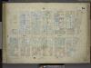
[Plate 15: Map bounded by Church Street, Canal Street, Elm Street, Pearl Street; Including Franklyn Place, Broadway, Benson Street, Courtlandt Alley, Worth Street, Leonard Street, Franklin Street, White Street, Walker Street, Lispenard St
from Maps of the city of New-York.
[Plate 15: Map bounded by Canal Street, Elm Street, Pearl street, Church Street]
from Maps of the city of New York.
Manhattan, V. 1, Plate No. 21 south half [Map bounded by Thompson St., Grand St., Broadway, Canal St.]
From Atlas 107. Vol. 1, 1894.
Manhattan, V. 1, Plate No. 23 [Map bounded by Broome St., Bowery, Canal St., Baxter St.]
From Atlas 107. Vol. 1, 1894.
Manhattan, V. 1, Plate No. 21 [Map bounded by Thompson St., Spring St., Broadway, Grand St.]
From Atlas 107. Vol. 1, 1894.
A view of Collect Pond and its vicinity in the City of New York in 1793 : on which pond the first boat propelled by paddle wheels and screw-propellers constructed by John Fitch, six years before Robert Fulton ... / by John Hutchings ; drawn & lith. b
from Manhattan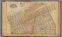
3. Wards 5, 8.
1 : 2400 G.W. Bromley & Co.; Geo. W. Bromley & E. Robinson
Manhattan, V. 1, Plate No. 71 [Map bounded by W. Houston St., Wooster St., Spring St., Sullivan St.]
From Atlas 108. Vol. 1, [1903?].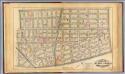
4. Wards 5-6, 8, 14.
1 : 2400 G.W. Bromley & Co.; Geo. W. Bromley & E. Robinson
Part of Sections 1 & 2 : New York City.
from Atlas of the city of New York, borough of Manhattan. From actual surveys and official plans / by George W. and Walter S. Bromley.
Part of Sections 1 & 2 : New York City.
from Atlas of the city of New York, Manhattan Island. From actual surveys and official plans / by George W. and Walter S. Bromley.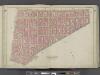
Manhattan, Double Page Plate No. 5 [Map bounded by Broome St., Division St., Pearl St., Centre St.]
From Atlas of the city of New York, Manhattan Island. From actual surveys and official plans
Part of Sections 1 & 2 : New York City.
from Atlas of the city of New York, Manhattan Island. From actual surveys and official plans / by George W. and Walter S. Bromley.
Plate 8: Bounded by W. 3rd Street, Great Jones Street, E. 3rd Street, Avenue A, Essex Street, Broome Street and West Broadway.
from Atlas of the city of New York, Manhattan Island. From actual surveys and official plans / by George W. and Walter S. Bromley.
[Plate 4: Bounded by Spring Street, Hudson Street, Broome Street, Centre Street, Pearl Street, Thomas Street, Hudson Street, Jay Sreet and [Hudson River, Piers 22-34] West Street.]
from Atlas of the city of New York, borough of Manhattan. From actual surveys and official plans / by George W. and Walter S. Bromley.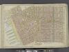
Manhattan, Double Page Plate No. 4 [Map bounded by Spring St., Broome St., Centre St., Pearl St., Thomas St., Jay St., Hudson River]
From Atlas of the city of New York, Manhattan Island. From actual surveys and official plans
[Plate 8: Bounded by W. 3rd Street, Great Jones Street,E. 3rd Street, Avenue A, Essex Street, Broome Street, and West Broadway.]
from Atlas of the city of New York, borough of Manhattan. From actual surveys and official plans / by George W. and Walter S. Bromley.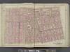
![Manhattan, V. 1, Plate No. 23 west half [Map bounded by Broome St., Baxter St., Canal St., Broadway]](https://images-2.georeferencer.com/images/iiif/582045863140/full/,300/0/native.jpg)

