Maps of Hudson County

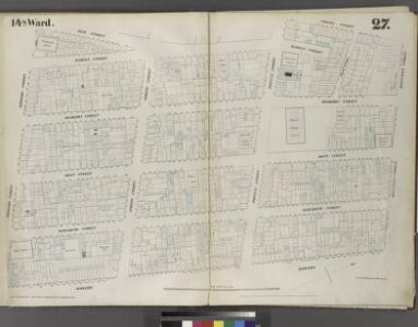
Plate 27: Map bounded by Houston Street, Bowery, Broome Street, Elm Street, Prince Street, Crosby Street.
from Maps of the city of New York / surveyed under directions of insurance companies of said city.
Plate 24: Map bounded by Houston Street, Bowery, Broome Street, Crosby Street
from Maps of the city of New York.
[Plate 24: Map bounded by Crosby Street, E.Houston Street, Bowery, Broome Street; Including Elm Street, Marion Street, Mulberry Street, Mott Street, Elizabeth Street, Spring Street, Prince Street]
from Maps of the city of New-York.
Manhattan, V. 1, Double Page Plate No. 24 [Map bounded by Broadway, E. Houston St., Bowery, Broome St., Elizabeth St.]
From Atlas 107. Vol. 1, 1894.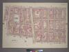
Plate 19, Part of Section 2: [Bounded by E. Houston Street, Orchard Street, Delancey Street, Bowery Street, Spring Street, Elm Street, Prince Street and Crosby Street.]
from Atlas of the city of New York, borough of Manhattan. From actual surveys and official plans / by George W. and Walter S. Bromley.
Part of section 2: Plate 19.
from Atlas of the borough of Manhattan, city of New York.
Plate 41: Map bounded by Houston Street, Allen Street, First Street, Essex Street, Rivington Street, Bowery.
from Maps of the city of New York / surveyed under directions of insurance companies of said city.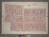
Plate 18, Part of Sections 1&2: [Bounded by Spring Street, Bowery Street, Delancey Street, Orchard Street, Hester Street, Mulberry Street, Grand Street, Centre Street and Marion Street.]
from Atlas of the city of New York, borough of Manhattan. From actual surveys and official plans / by George W. and Walter S. Bromley.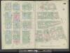
Manhattan, V. 3, Double Page Plate No. 49 [Map bounded by E. 4th St., Bowery, E. Houston St., W. Houston St., Greene St., W. 4th St.]
From Atlas 42.53. Vol. 3, 1895.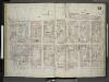
[Plate 33: Map bounded by First Street, Essex Street, Rivington Street, Bowery; Including Stanton Street, Christie Street, Forsyth Street, Eldridge Street, First Avenue, Allen Street, Orchard Street, Ludlow Street, Avenue A]
from Insurance maps of the city of New York.
Plate 32: Map bounded by Houston Street, Crosby Street, Prince Street, Marion Street, Spring Street, Laurens Street.
from Maps of the city of New York / surveyed under directions of insurance companies of said city.
Plate 24: Map bounded by Bowery, Rivington Street, Allen Street, Grand Street.
from Maps of the city of New York / surveyed under directions of insurance companies of said city.
Plate 49: Map bounded by 4th Street, Bowery, Houston Street, Green Street
from Maps of the city of New York.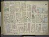
[Plate 23: Map bounded by Canal Street, Broadway, Broome Street, Bowery; Including Hester Street, Howard Street, Grand Street, Elizabeth Street, Mott Street, Mulberry Street, Baxter Street, Centre Market Place, Centre Street, Elm Street, C
from Maps of the city of New-York.
Plate 30: Map bounded by Spring Street, Elm Street, Broome Street, Centre Street, Canal Street, Mercer Street.
from Maps of the city of New York / surveyed under directions of insurance companies of said city.
Plate 33: Map bounded by Houston Street, Allen Street, 1st Street, Essex Street, Rivington Street, Bowery
from Maps of the city of New York.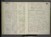
[Plate 57: Map bounded by East 4th Street, Bowery, Houston Street, Green Street.]
from Maps of the city of New York / surveyed under directions of insurance companies of said city.
Manhattan, V. 1, Plate No. 22 [Map bounded by W. Houston St., Broadway, Spring St., Wooster St.]
From Atlas 107. Vol. 1, 1894.
Manhattan, V. 1, Plate No. 23 [Map bounded by Broome St., Bowery, Canal St., Baxter St.]
From Atlas 107. Vol. 1, 1894.
Manhattan, V. 2, Plate No. 2 [Map bounded by 1st St., Allen St., Rivington St., Chrystie St.]
From Atlas 110. Vol. 2, 1903.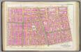
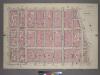
Pl. 8: wards 8, 10, 14-15, 17.
1 : 1800 Bromley, George Washington; Bromley, Walter Scott
Plate 8: Bounded by W. 3rd Street, Great Jones Street, E. 3rd Street, Avenue A, Essex Street, Broome Street and West Broadway.
from Atlas of the city of New York, Manhattan Island. From actual surveys and official plans / by George W. and Walter S. Bromley.
[Plate 8: Bounded by W. 3rd Street, Great Jones Street,E. 3rd Street, Avenue A, Essex Street, Broome Street, and West Broadway.]
from Atlas of the city of New York, borough of Manhattan. From actual surveys and official plans / by George W. and Walter S. Bromley.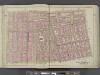
Manhattan, Double Page Plate No. 8 [Map bounded by W. 3rd St., E. 3rd St., Essex Ave., Broome St., S. 5th Ave.]
From Atlas of the city of New York, Manhattan Island. From actual surveys and official plans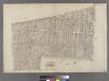
Part of Ward 17, New York City.
from Atlas of the city of New York : embracing all territory within its corporate limits from official records, private plans & actual surveys / by and under the supervision of E. Robinson & R.H. Pidgeon, civil engineers.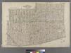
[Plate 4: West Broadway, Canal Street, Sullivan Street, W. Houston Street, Bowery Street, New Bowery Square, New Chambers Street, Chambers Street, Broadway and Reade Street. ]
from Atlas of the city of New York : embracing all territory within its corporate limits from official records, private plans & actual surveys / by and under the supervision of E. Robinson & R.H. Pidgeon, civil engineers.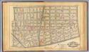
4. Wards 5-6, 8, 14.
1 : 2400 G.W. Bromley & Co.; Geo. W. Bromley & E. Robinson
Part of Section 2 : Plate 20.
from Atlas of the borough of Manhattan, city of New York.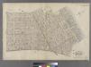
[Plate 5: Bounded by Clinton Street, Madison Street, Jefferson Street, Cherry Street, Rutgers Slip, South Street (East River, Piers 32-44), James Slip, New Chambers Street, New Bowery Street, Bowery Street and Rivington Street.]
from Atlas of the city of New York : embracing all territory within its corporate limits from official records, private plans & actual surveys / by and under the supervision of E. Robinson & R.H. Pidgeon, civil engineers.