Maps of Split-Dalmatia County

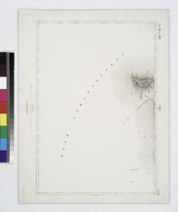
I. Busi.
from Spezialkarte der osterreichisch-ungarischen Monarchie.
Zone 34, Col. XIV, I. Busi, uit: Geologische Karte der im Reichsrathe vertretenen Königreiche und Länder der Österreich-Ungarischen Monarchie : auf Grundlage der Specialkarte i.M. 1:75.000 des k.u.k. Militär-geographischen Institutes / neu bearb. und als Kartenwerk von 341 Blattnummern in zwanglosen Lfg. hrsg. durch die k.k. Geologische Reichsanstalt in Wien
1 : 75000 titelvariant: Geologische Spezialkarte der im Reichsrate vertretenen Königreiche und Länder der Österreichisch-Ungarischen Monarchie; Geologische Specialkarte der im Reichsrathe vertretenen Königreiche und Länder der Österreichisch-Ungarischen Monarchie; Annotatie: Titel bovenaan kaartblad: Geologische Spezialkarte der im Reichsrate vertretenen Königreiche und Länder der Österreichisch-Ungarischen Monarchie en Geologische Specialkarte der im Reichsrathe vertretenen Königreiche und Länder der Österreichisch-Ungarischen Monarchie; Annotatie geografische gegevens: Coördinaten gebaseerd op nulmeridiaan van Ferro (Hierro) Kaiserlich-Königliche Geologische Reichsanstalt, Wenen Wien : K.K. Geologische Reichsanstalt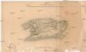
Plan der Insel Lissa
1 : 74500 Vis, ostrov (Chorvatsko)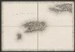
[Vis]
Kroatien Dalmatien Vis (Kroatien) Umland
I. Lissa [Vis].
from Spezialkarte der osterreichisch-ungarischen Monarchie.
Bis
1 : 200000 Vis (Chorvatsko : ostrov) Kartografska radionica
Generalkarte von Zentraleuropa

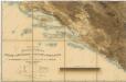
Adriatisches Meer, Küstenkarte
1 : 180000 Hvar (Chorvatsko : ostrov) Oesterreicher, Tobias von Hydrographisches Amt der k. u. k. Kriegs-Marine
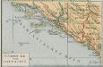
Charte des sudöstlichen Theiles von Dalmatien mit dem oesterreichischen Antheile von Albanien
Albánie im Verlage des Kunst und Industrie Comptoirs
Skelet-Karte für Curs-Skizzen
Chorvatsko K. u. k. Kriegs-Marine
Partie de la Dalmatie du sud est avec l'Albanie
Albánie im Verlage des Kunst und Industrie Comptoirs
Charte des sudöstlichen Theiles von Dalmatien mit dem Oesterreichischen Antheile von Albanien
1 : 540000 Albánie Kipferling, Karl Joseph
Velaluka.
from Spezialkarte der osterreichisch-ungarischen Monarchie.
I. St. Andrea.
from Spezialkarte der osterreichisch-ungarischen Monarchie.
Sv. Petar, I. Pelagosa und Scg. Cajola.
from Spezialkarte der osterreichisch-ungarischen Monarchie.
[Nebenkarte Svetac zur Umgebung von Šolta]
Kroatien Dalmatien Šolta Umland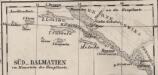
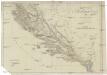
Süd-Dalmatien
Dalmatien
Eisenbahnkarte der k.u.k. oesterreichisch-ungarischen Monarchie
Hypsometrische uibersichtskarte von Bosnien der Herzegovina von Serbien und Montenegro
Südlicher Teil von Dalmatien
Dalmatien (Süd)
Dalmatien und seine Hinterländer
1 : 1700000 Kroatien Dalmatien Bosnien Herzegowina
Übersichtskarte von Mittel - Europa

Sheet XVIII: Karte Des Oesterreichischen Kaiserstaates.
1 : 576000 Scheda, Josef
Dalmatien und Montenegro
Kroatien, Montenegro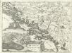
Regnum Dalmatiae
1 : 1200000 Mollova mapová sbírka Bruggen, Johann van der Brugge, Johannes van der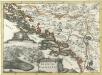
Regnum Dalmatiae
1 : 1200000 Mollova mapová sbírka Bruggen, Johann van der Brugge, Johannes van der
XVIII, uit: General-Karte des oesterreichischen Kaiserstaates mit einem grossen Theile der angrenzenden Länder / durch Josef Scheda ... bearb. und hrsg
1 : 576000 Annotatie geografische gegevens: Maatstokken: oesterreichische Meilen, geografische oder deutsche Meilen, preussische Meilen, türkische Berri, französische Lieues, russische Werste; Maatstok per blad: wiener Klafter, öster. Meilen; Blad XIX: statistische en taalkundige informatie; Blad XIX: legenda [Wien : K.K. Militärisch-Geografisches Institut]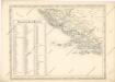
Strassen und Eisenbahnkarte des oesterreichischen Kaiserthumes
Oestreichisch Dalmatien und Albanien
1 : 930000 Albánie Mollo, Tranquillo Tranquillo Mollo