Maps of Split

Bis
1 : 200000 Vis (Chorvatsko : ostrov) Kartografska radionica
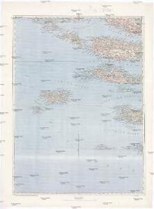
Adriatisches Meer, Küstenkarte
1 : 180000 Hvar (Chorvatsko : ostrov) Oesterreicher, Tobias von Hydrographisches Amt der k. u. k. Kriegs-Marine
I. Lissa [Vis].
from Spezialkarte der osterreichisch-ungarischen Monarchie.
I. Busi.
from Spezialkarte der osterreichisch-ungarischen Monarchie.
Lesina.
from Spezialkarte der osterreichisch-ungarischen Monarchie.
Velaluka.
from Spezialkarte der osterreichisch-ungarischen Monarchie.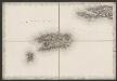
[Vis]
Kroatien Dalmatien Vis (Kroatien) Umland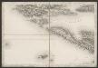
[Umgebung von Šolta]
Kroatien Dalmatien Šolta Umland
Sv. Petar, I. Pelagosa und Scg. Cajola.
from Spezialkarte der osterreichisch-ungarischen Monarchie.
I. Solta.
from Spezialkarte der osterreichisch-ungarischen Monarchie.
Almissa und S. Pietro Della Brazza.
from Spezialkarte der osterreichisch-ungarischen Monarchie.
Zone 32, Col. XIV, I. Solta, uit: Geologische Karte der im Reichsrathe vertretenen Königreiche und Länder der Österreich-Ungarischen Monarchie : auf Grundlage der Specialkarte i.M. 1:75.000 des k.u.k. Militär-geographischen Institutes / neu bearb. und als Kartenwerk von 341 Blattnummern in zwanglosen Lfg. hrsg. durch die k.k. Geologische Reichsanstalt in Wien
1 : 75000 titelvariant: Geologische Spezialkarte der im Reichsrate vertretenen Königreiche und Länder der Österreichisch-Ungarischen Monarchie; Geologische Specialkarte der im Reichsrathe vertretenen Königreiche und Länder der Österreichisch-Ungarischen Monarchie; Annotatie: Titel bovenaan kaartblad: Geologische Spezialkarte der im Reichsrate vertretenen Königreiche und Länder der Österreichisch-Ungarischen Monarchie en Geologische Specialkarte der im Reichsrathe vertretenen Königreiche und Länder der Österreichisch-Ungarischen Monarchie; Annotatie geografische gegevens: Coördinaten gebaseerd op nulmeridiaan van Ferro (Hierro) Kaiserlich-Königliche Geologische Reichsanstalt, Wenen Wien : K.K. Geologische Reichsanstalt
Zone 34, Col. XIV, I. Busi, uit: Geologische Karte der im Reichsrathe vertretenen Königreiche und Länder der Österreich-Ungarischen Monarchie : auf Grundlage der Specialkarte i.M. 1:75.000 des k.u.k. Militär-geographischen Institutes / neu bearb. und als Kartenwerk von 341 Blattnummern in zwanglosen Lfg. hrsg. durch die k.k. Geologische Reichsanstalt in Wien
1 : 75000 titelvariant: Geologische Spezialkarte der im Reichsrate vertretenen Königreiche und Länder der Österreichisch-Ungarischen Monarchie; Geologische Specialkarte der im Reichsrathe vertretenen Königreiche und Länder der Österreichisch-Ungarischen Monarchie; Annotatie: Titel bovenaan kaartblad: Geologische Spezialkarte der im Reichsrate vertretenen Königreiche und Länder der Österreichisch-Ungarischen Monarchie en Geologische Specialkarte der im Reichsrathe vertretenen Königreiche und Länder der Österreichisch-Ungarischen Monarchie; Annotatie geografische gegevens: Coördinaten gebaseerd op nulmeridiaan van Ferro (Hierro) Kaiserlich-Königliche Geologische Reichsanstalt, Wenen Wien : K.K. Geologische Reichsanstalt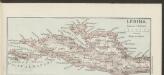
Lesina [Westhälfte]
1 : 200000 Kroatien Hvar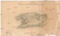
Plan der Insel Lissa
1 : 74500 Vis, ostrov (Chorvatsko)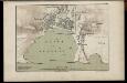
Hafen von Spalato
1 : 12000 Spalato Hafen Freytag, Gustav
Plan der Stadt Spalato
Kroatien Split Stadtplan
Plan von Spalato
1 : 8600 Kroatien Split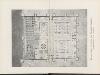
Reconstruierter Grundriss des Diocletian-Palastes
Kroatien Split Diokletianpalast (Split) Diokletian
Plan of Diocletian's Palace
Kroatien Split Diokletianpalast (Split)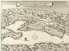
Delineatio Situsve Provinciae circa Clissam & Spalatum
1 : 90000 Mollova mapová sbírka Merian, Matthaeus Merian, Matthäus - dědici
[Lastovo]
Kroatien Dalmatien Lastovo Umland
Skelet-Karte für Curs-Skizzen
Chorvatsko K. u. k. Kriegs-Marine
Eisenbahnkarte der k.u.k. oesterreichisch-ungarischen Monarchie

Partie de la Dalmatie du sud est avec l'Albanie
Albánie im Verlage des Kunst und Industrie Comptoirs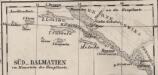
Süd-Dalmatien
Dalmatien
Charte des sudöstlichen Theiles von Dalmatien mit dem oesterreichischen Antheile von Albanien
Albánie im Verlage des Kunst und Industrie Comptoirs
Charte des sudöstlichen Theiles von Dalmatien mit dem Oesterreichischen Antheile von Albanien
1 : 540000 Albánie Kipferling, Karl Joseph
Generalkarte von Zentraleuropa