Maps of Splitsko-Dalmatinska

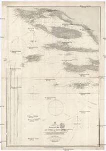
Adriatisches Meer, Küstenkarte
1 : 180000 Hvar (Chorvatsko : ostrov) Oesterreicher, Tobias von Hydrographisches Amt der k. u. k. Kriegs-Marine
Bis
1 : 200000 Vis (Chorvatsko : ostrov) Kartografska radionica
Charte des sudöstlichen Theiles von Dalmatien mit dem Oesterreichischen Antheile von Albanien
1 : 540000 Albánie Kipferling, Karl Joseph
Generalkarte von Zentraleuropa

Sv. Petar, I. Pelagosa und Scg. Cajola.
from Spezialkarte der osterreichisch-ungarischen Monarchie.
Velaluka.
from Spezialkarte der osterreichisch-ungarischen Monarchie.
Lesina.
from Spezialkarte der osterreichisch-ungarischen Monarchie.
I. Solta.
from Spezialkarte der osterreichisch-ungarischen Monarchie.
I. Lissa [Vis].
from Spezialkarte der osterreichisch-ungarischen Monarchie.
Almissa und S. Pietro Della Brazza.
from Spezialkarte der osterreichisch-ungarischen Monarchie.
I. Busi.
from Spezialkarte der osterreichisch-ungarischen Monarchie.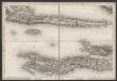
[Kanal von Korčula]
Kroatien Dalmatien Korčula Umland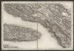
[Kanal von Brač]
Kroatien Dalmatien Brač Umland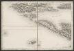
[Umgebung von Šolta]
Kroatien Dalmatien Šolta Umland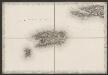
[Vis]
Kroatien Dalmatien Vis (Kroatien) Umland
Skize der Gegend bey Imoschi
1 : 92439 Imotski, Umland Jabornigg von Altenfels, Rudolf
Imotski und Macarsca.
from Spezialkarte der osterreichisch-ungarischen Monarchie.
Sebenico und Trau.
from Spezialkarte der osterreichisch-ungarischen Monarchie.
Porto Rosso.
from Spezialkarte der osterreichisch-ungarischen Monarchie.
Sinj und Spalato.
from Spezialkarte der osterreichisch-ungarischen Monarchie.
Zone 32, Col. XIV, I. Solta, uit: Geologische Karte der im Reichsrathe vertretenen Königreiche und Länder der Österreich-Ungarischen Monarchie : auf Grundlage der Specialkarte i.M. 1:75.000 des k.u.k. Militär-geographischen Institutes / neu bearb. und als Kartenwerk von 341 Blattnummern in zwanglosen Lfg. hrsg. durch die k.k. Geologische Reichsanstalt in Wien
1 : 75000 titelvariant: Geologische Spezialkarte der im Reichsrate vertretenen Königreiche und Länder der Österreichisch-Ungarischen Monarchie; Geologische Specialkarte der im Reichsrathe vertretenen Königreiche und Länder der Österreichisch-Ungarischen Monarchie; Annotatie: Titel bovenaan kaartblad: Geologische Spezialkarte der im Reichsrate vertretenen Königreiche und Länder der Österreichisch-Ungarischen Monarchie en Geologische Specialkarte der im Reichsrathe vertretenen Königreiche und Länder der Österreichisch-Ungarischen Monarchie; Annotatie geografische gegevens: Coördinaten gebaseerd op nulmeridiaan van Ferro (Hierro) Kaiserlich-Königliche Geologische Reichsanstalt, Wenen Wien : K.K. Geologische Reichsanstalt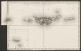
[Lastovo]
Kroatien Dalmatien Lastovo Umland
Zone 34, Col. XIV, I. Busi, uit: Geologische Karte der im Reichsrathe vertretenen Königreiche und Länder der Österreich-Ungarischen Monarchie : auf Grundlage der Specialkarte i.M. 1:75.000 des k.u.k. Militär-geographischen Institutes / neu bearb. und als Kartenwerk von 341 Blattnummern in zwanglosen Lfg. hrsg. durch die k.k. Geologische Reichsanstalt in Wien
1 : 75000 titelvariant: Geologische Spezialkarte der im Reichsrate vertretenen Königreiche und Länder der Österreichisch-Ungarischen Monarchie; Geologische Specialkarte der im Reichsrathe vertretenen Königreiche und Länder der Österreichisch-Ungarischen Monarchie; Annotatie: Titel bovenaan kaartblad: Geologische Spezialkarte der im Reichsrate vertretenen Königreiche und Länder der Österreichisch-Ungarischen Monarchie en Geologische Specialkarte der im Reichsrathe vertretenen Königreiche und Länder der Österreichisch-Ungarischen Monarchie; Annotatie geografische gegevens: Coördinaten gebaseerd op nulmeridiaan van Ferro (Hierro) Kaiserlich-Königliche Geologische Reichsanstalt, Wenen Wien : K.K. Geologische Reichsanstalt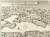
Delineatio Situsve Provinciae circa Clissam & Spalatum
1 : 90000 Mollova mapová sbírka Merian, Matthaeus Merian, Matthäus - dědici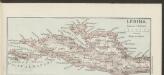
Lesina [Westhälfte]
1 : 200000 Kroatien Hvar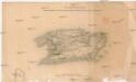
Plan der Insel Lissa
1 : 74500 Vis, ostrov (Chorvatsko)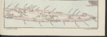
Lesina [Osthälfte]
1 : 200000 Kroatien Hvar
Plan of the Excavacations of Salona
1 : 12000 Kroatien Salona Ausgrabung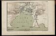
Hafen von Spalato
1 : 12000 Spalato Hafen Freytag, Gustav