Maps of Resita

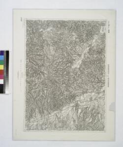
Karansebes und Resicabanya.
from Spezialkarte der osterreichisch-ungarischen Monarchie.
Karánsebes und Resicabánya
1 : 75000 Reșița, Caransebeş Geripp: Fwkr. Krainz. Terrain: Hauptm. Pitron u. Oblt. Trica
Lambert-Cholesky sheet 2055 (Fârliug)
1 : 20000 Romanian military topographic map sheet under Lambert-Cholensky projection Direcția Topografică Militară geo-spatial.org Direcția Topografică Militară
Lambert-Cholesky sheet 2054 (Bocşa Montană)
1 : 20000 Romanian military topographic map sheet under Lambert-Cholensky projection Serviciul Geografic al Armatei geo-spatial.org Serviciul Geografic al Armatei
Lambert-Cholesky sheet 2053 (Reşita)
1 : 20000 Romanian military topographic map sheet under Lambert-Cholensky projection Direcția Topografică Militară geo-spatial.org Direcția Topografică Militară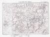
Lambert-Cholesky sheet 2155 (Ohaba Mâtnicului)
1 : 20000 Romanian military topographic map sheet under Lambert-Cholensky projection Direcția Topografică Militară geo-spatial.org Direcția Topografică Militară
Lambert-Cholesky sheet 2154 (Delineşti)
1 : 20000 Romanian military topographic map sheet under Lambert-Cholensky projection Serviciul Geografic al Armatei geo-spatial.org Serviciul Geografic al Armatei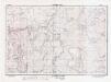
Lambert-Cholesky sheet 2153 (Cuptoare Secu)
1 : 20000 Romanian military topographic map sheet under Lambert-Cholensky projection Direcția Topografică Militară geo-spatial.org Direcția Topografică Militară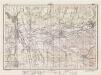
Lambert-Cholesky sheet 2255 (Obreja)
1 : 20000 Romanian military topographic map sheet under Lambert-Cholensky projection Direcția Topografică Militară geo-spatial.org Direcția Topografică Militară
Lambert-Cholesky sheet 2254 (Caransebeş)
1 : 20000 Romanian military topographic map sheet under Lambert-Cholensky projection Direcția Topografică Militară geo-spatial.org Direcția Topografică Militară
Lambert-Cholesky sheet 2253 (Slatina Timişului)
1 : 20000 Romanian military topographic map sheet under Lambert-Cholensky projection Direcția Topografică Militară geo-spatial.org Direcția Topografică Militară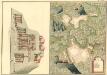
Plan von Bergwerg Racksest, und Bocza
Mollova mapová sbírka Geyer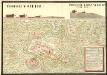
Proiect von Karansebes von dem Herren Obrist Liutin ont von Suly den Kais. Hoffkrigs Rat Hüber geben vnd Approbiret Anno MDCCXL
Mollova mapová sbírka Geyer
Lambert-Cholesky sheet 2252 (Armeniş)
1 : 20000 Romanian military topographic map sheet under Lambert-Cholensky projection Direcția Topografică Militară geo-spatial.org Direcția Topografică Militară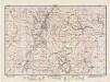
Lambert-Cholesky sheet 2152 (Valiug)
1 : 20000 Romanian military topographic map sheet under Lambert-Cholensky projection Direcția Topografică Militară geo-spatial.org Direcția Topografică Militară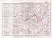
Lambert-Cholesky sheet 2052 (Carașova)
1 : 20000 Romanian military topographic map sheet under Lambert-Cholensky projection Direcția Topografică Militară geo-spatial.org Direcția Topografică Militară
Krassova und Teregova.
from Spezialkarte der osterreichisch-ungarischen Monarchie.
Gattaja und Dognacska.
from Spezialkarte der osterreichisch-ungarischen Monarchie.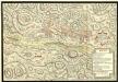
Action de Mehadia Gagne Svr les Infideles par les Trouppes Imperiales le 15. Iuillet 1738
Mollova mapová sbírka Geyer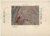
Zone 25, Kol. XXVI, Krassova und Teregova, uit: [Geologische Specialkarte der im Reichsrathe vertretenen Königreiche und Länder der österreichisch-ungarischen Monarchie] / geologische Aufnahmen der königl. ung. Geologischen Anstalt
1 : 75000 Annotatie: Verantwoordelijkheidsvermelding in 1909 veranderd in: Königliche Ungarische Geologische Reichsanstalt; Sommige bladen in het Frans; Annotatie geografische gegevens: Coördinaten gebaseerd op nulmeridiaan van Ferro (Hierro) Königliche Ungarische Geologische Reichsanstalt; Königliche Ungarische Geologische Anstalt Budapest : [Königliche Ungarische Geologische Anstalt]
Krassova und Teregova
1 : 75000 Caraşova, Caraş-Severin Geripp: Offic. Höller u. Offic. M. Jakupec. Terrain: Oblt. G. Brenner u. Lieut. Sied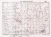
Lambert-Cholesky sheet 2056 (Scăiuş)
1 : 20000 Romanian military topographic map sheet under Lambert-Cholensky projection Serviciul Geografic al Armatei geo-spatial.org Serviciul Geografic al Armatei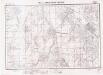
Lambert-Cholesky sheet 2156 (Sălbăgel)
1 : 20000 Romanian military topographic map sheet under Lambert-Cholensky projection Serviciul Geografic al Armatei geo-spatial.org Serviciul Geografic al Armatei
Lambert-Cholesky sheet 2256 (Căvăran)
1 : 20000 Romanian military topographic map sheet under Lambert-Cholensky projection Direcția Topografică Militară geo-spatial.org Direcția Topografică Militară
Lambert-Cholesky sheet 2355 (Măru)
1 : 20000 Romanian military topographic map sheet under Lambert-Cholensky projection Direcția Topografică Militară geo-spatial.org Direcția Topografică Militară
Lambert-Cholesky sheet 2354 (Borlova)
1 : 20000 Romanian military topographic map sheet under Lambert-Cholensky projection Institutul Geografic al Armatei geo-spatial.org Institutul Geografic al Armatei
Lambert-Cholesky sheet 2353 (Ilova)
1 : 20000 Romanian military topographic map sheet under Lambert-Cholensky projection Direcția Topografică Militară geo-spatial.org Direcția Topografică Militară
Lambert-Cholesky sheet 2352 (Feneş)
1 : 20000 Romanian military topographic map sheet under Lambert-Cholensky projection Direcția Topografică Militară geo-spatial.org Direcția Topografică Militară
Jižní část krašovské stolice s českými osadami
Banat Tschechen