Maps of Resita

Gattaja und Dognacska.
from Spezialkarte der osterreichisch-ungarischen Monarchie.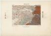
Zone 24, Kol. XXV, Dognacska und Gattaja, uit: [Geologische Specialkarte der im Reichsrathe vertretenen Königreiche und Länder der österreichisch-ungarischen Monarchie] / geologische Aufnahmen der königl. ung. Geologischen Anstalt
1 : 75000 Annotatie: Verantwoordelijkheidsvermelding in 1909 veranderd in: Königliche Ungarische Geologische Reichsanstalt; Sommige bladen in het Frans; Annotatie geografische gegevens: Coördinaten gebaseerd op nulmeridiaan van Ferro (Hierro) Königliche Ungarische Geologische Reichsanstalt; Königliche Ungarische Geologische Anstalt Budapest : [Königliche Ungarische Geologische Anstalt]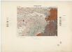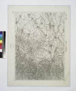
Gátalja und Dognácska
1 : 75000 Gătaia (Timiş) Geripp: Offizial Leitner. Terrain: Oberlt. Zbożen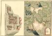
Plan von Bergwerg Racksest, und Bocza
Mollova mapová sbírka Geyer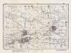
Lambert-Cholesky sheet 1855 (Gătaia)
1 : 20000 Romanian military topographic map sheet under Lambert-Cholensky projection Direcția Topografică Militară geo-spatial.org Direcția Topografică Militară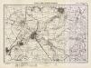
Lambert-Cholesky sheet 1854 (Semlacul Mare)
1 : 20000 Romanian military topographic map sheet under Lambert-Cholensky projection Direcția Topografică Militară geo-spatial.org Direcția Topografică Militară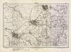
Lambert-Cholesky sheet 1853 (Clopodia)
1 : 20000 Romanian military topographic map sheet under Lambert-Cholensky projection Direcția Topografică Militară geo-spatial.org Direcția Topografică Militară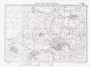
Lambert-Cholesky sheet 1955 (Ramna)
1 : 20000 Romanian military topographic map sheet under Lambert-Cholensky projection Direcția Topografică Militară geo-spatial.org Direcția Topografică Militară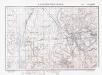
Lambert-Cholesky sheet 1954 (Bocşa Română)
1 : 20000 Romanian military topographic map sheet under Lambert-Cholensky projection Direcția Topografică Militară geo-spatial.org Direcția Topografică Militară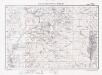
Lambert-Cholesky sheet 1953 (Doclin)
1 : 20000 Romanian military topographic map sheet under Lambert-Cholensky projection Institutul Geografic al Armatei geo-spatial.org Institutul Geografic al Armatei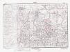
Lambert-Cholesky sheet 2055 (Fârliug)
1 : 20000 Romanian military topographic map sheet under Lambert-Cholensky projection Direcția Topografică Militară geo-spatial.org Direcția Topografică Militară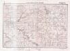
Lambert-Cholesky sheet 2054 (Bocşa Montană)
1 : 20000 Romanian military topographic map sheet under Lambert-Cholensky projection Serviciul Geografic al Armatei geo-spatial.org Serviciul Geografic al Armatei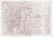
Lambert-Cholesky sheet 2053 (Reşita)
1 : 20000 Romanian military topographic map sheet under Lambert-Cholensky projection Direcția Topografică Militară geo-spatial.org Direcția Topografică Militară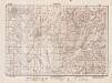
Lambert-Cholesky sheet 1952 (Cârnecea)
1 : 20000 Romanian military topographic map sheet under Lambert-Cholensky projection Direcția Topografică Militară geo-spatial.org Direcția Topografică Militară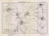
Lambert-Cholesky sheet 1753 (Moraviţa)
1 : 20000 Romanian military topographic map sheet under Lambert-Cholensky projection Serviciul Geografic al Armatei geo-spatial.org Serviciul Geografic al Armatei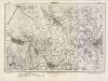
Lambert-Cholesky sheet 1852 (Temeskutas)
1 : 20000 Romanian military topographic map sheet under Lambert-Cholensky projection Direcția Topografică Militară geo-spatial.org Direcția Topografică Militară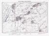
Lambert-Cholesky sheet 1754 (Detta)
1 : 20000 Romanian military topographic map sheet under Lambert-Cholensky projection Serviciul Geografic al Armatei geo-spatial.org Serviciul Geografic al Armatei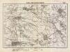
Lambert-Cholesky sheet 1856 (Cerna)
1 : 20000 Romanian military topographic map sheet under Lambert-Cholensky projection Direcția Topografică Militară geo-spatial.org Direcția Topografică Militară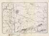
Lambert-Cholesky sheet 1755 (Vejte)
1 : 20000 Romanian military topographic map sheet under Lambert-Cholensky projection Direcția Topografică Militară geo-spatial.org Direcția Topografică Militară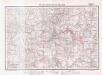
Lambert-Cholesky sheet 2052 (Carașova)
1 : 20000 Romanian military topographic map sheet under Lambert-Cholensky projection Direcția Topografică Militară geo-spatial.org Direcția Topografică Militară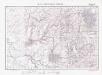
Lambert-Cholesky sheet 1956 (Sacoşul-Mare)
1 : 20000 Romanian military topographic map sheet under Lambert-Cholensky projection Serviciul Geografic al Armatei geo-spatial.org Serviciul Geografic al Armatei
Temes-Kutas und D.-Oravica.
from Spezialkarte der osterreichisch-ungarischen Monarchie.
Karansebes und Resicabanya.
from Spezialkarte der osterreichisch-ungarischen Monarchie.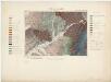
Zone 25, Kol. XXV, Temeskutas und Oraviczabánya, uit: [Geologische Specialkarte der im Reichsrathe vertretenen Königreiche und Länder der österreichisch-ungarischen Monarchie] / geologische Aufnahmen der königl. ung. Geologischen Anstalt
1 : 75000 Annotatie: Verantwoordelijkheidsvermelding in 1909 veranderd in: Königliche Ungarische Geologische Reichsanstalt; Sommige bladen in het Frans; Annotatie geografische gegevens: Coördinaten gebaseerd op nulmeridiaan van Ferro (Hierro) Königliche Ungarische Geologische Reichsanstalt; Königliche Ungarische Geologische Anstalt Budapest : [Königliche Ungarische Geologische Anstalt]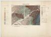
Temes-Kutas und D.-Oravica
1 : 75000 Gudurica, Oravita Schrift u. Gerippe v. Assistent Holl. Terrainschraffirung von Offizial Pflügl
Buziás
1 : 75000 Buziaș Geripp: Fwkr. Heller. Terrain: J. Le Gay Edl. v. Lierfels
Buziasfurdo.; Spezialkarte der osterreichisch-ungarischen Monarchie.
from Spezialkarte der osterreichisch-ungarischen Monarchie. Austro-Hungarian Monarchy. Militärgeographisches Institut.,