Maps of Lithuania

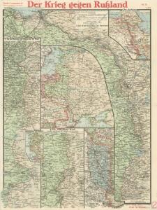
Paasche's Frontenkarte, Nr.10. Der Krieg gegen Russland

Übersichtskarte von Mittel - Europa

[Lietuvos žemelapis]
Litva
Dwinsk (Dünaburg), Friedrichstadt
1 : 750000 Dokšycy (Bělorusko) K. u. k. Militärgeographisches Institut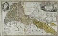
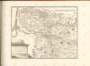
Per illustribus, generosissimis magnificis & excellentissimis dominis, dominis dvcatvvm Cvrlandiæ & Semgalliæ quatuor consiliariis supremis tabulam hanc dvcatvvm Cvrlandiæ & Semgalliæ geographicam
1 Karte : Kupferdruck ; 48 x 44 cm Barnickel Homännische Erben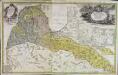
Per illustribus, generosissimis magnificis & excellentissimis dominis, dominis dvcatvvm Cvrlandiæ & Semgalliæ quatuor consiliariis supremis tabulam hanc dvcatvvm Cvrlandiæ & Semgalliæ geographicam
1 Karte : Kupferdruck ; 48 x 44 cm Barnickel Homännische Erben
Trigonometrisk grunnlag, vedlegg 65, 6-9: Grunnlagspunkter for Struves meridianbue fra Vilnius, Hrodna og Kurland
1 : 200000 de Tenner
[Vilnius a okolí]
1 : 38000 Vilnius-oblast (Litva) Frolov
Schawli 7, uit: Special-Karte von Mittel-Europa / nach amtlichen Quellen bearbeitet von W. Liebenow
1 : 300000 titelvariant: W. Liebenow's Mittel-Europa; Annotatie: Titel boven de bladen: W. Liebenow's Mittel-Europa Johannes Wilhelm Liebenow 1822-1897 Frankfurt a. M. : Ludwig Ravenstein
Kowno 9, uit: Special-Karte von Mittel-Europa / nach amtlichen Quellen bearbeitet von W. Liebenow
1 : 300000 titelvariant: W. Liebenow's Mittel-Europa; Annotatie: Titel boven de bladen: W. Liebenow's Mittel-Europa Johannes Wilhelm Liebenow 1822-1897 Frankfurt a. M. : Ludwig Ravenstein
Suwalki 19, uit: Special-Karte von Mittel-Europa / nach amtlichen Quellen bearbeitet von W. Liebenow
1 : 300000 titelvariant: W. Liebenow's Mittel-Europa; Annotatie: Titel boven de bladen: W. Liebenow's Mittel-Europa Johannes Wilhelm Liebenow 1822-1897 Frankfurt a. M. : Ludwig Ravenstein
Karte des westlichen Russlands O17

Karte des westlichen Russlands R16

Karte des westlichen Russlands S16

Karte des westlichen Russlands P17

Poland, Western Russia, Latvia and Lithuania [A map of]
This is sheet 322 of a series of maps was prepared for the German Army, and its numeration continues that of the Karte des Deutschen Reiches. Grossblatt 308-441A. [A map of Poland, western Russia, Latvia, and Lithuania, drawn in extension of the Karte des Deutschen Reiches 1:100,000 published by the Reichsamt für Landesaufnahme.]. Germany. Heer. Abteilung für Kriegskarten- und Vermessungswesen. [S.l.] : Hergestellt im Auftrage Gen St d H Abt f Kr Kart u Verm Wes (II)
[Kowno]
1 : 300000 Kaunas Belagerung, Weltkrieg <1914-1918>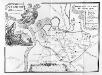
Vilnius. XVIII. šimtmečio pabaigoje
Vilnius Altstadt
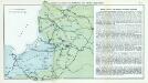
Verwaltungsgebiet Ober Ost. Einteilung der Kreise und Eisenbahnlinien
Baltikum Oberost Weltkrieg <1914-1918> Eisenbahnnetz
Kalnuotumo ir nuotakumo Lietuvos
1 : 630000 Lotyšsko Matulionis, P. S. Schropp'sche Lehrmittel-Handlung
Litauen, Kurland und Livland
1 : 725000 Kuronsko Carl Flemming
[Litauen, Lettland]
Litauen, Lettland, ethnische Gruppe
Verwaltungsgebiet Ober Ost und geschlossene Sprachgebiete
Baltikum Oberost Weltkrieg <1914-1918>
Ethnographische Karte von Litauen
1 : 2000000 Litauen Ethnische Gruppe Kettler, Julius Iwan (red.)
Mapa narodowościowa polskich kresów północno-wschodnich i Litwy
1 : 1000000 Litva Machlejd, Jerzy Zaborski, Bogdan Gebethner & Wolff
Strategische Übersichts-Karte des polnisch-litaurischen Armee-Bewegungraumes
Nr. 7. Kämpfe in Kurland und Nordpolen zum Schutze Ostpreußens
Baltikum Weltkrieg <1914-1918>, Ostfront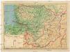
Lietuvos žemelapis
1 : 200000 Litva Spaudos fondas