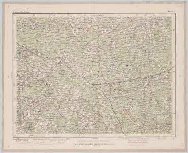
Maps of Siauliai County

Schawli 7, uit: Special-Karte von Mittel-Europa / nach amtlichen Quellen bearbeitet von W. Liebenow
1 : 300000 titelvariant: W. Liebenow's Mittel-Europa; Annotatie: Titel boven de bladen: W. Liebenow's Mittel-Europa Johannes Wilhelm Liebenow 1822-1897 Frankfurt a. M. : Ludwig Ravenstein
Karte des westlichen Russlands O17

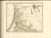
Regni Borussiae Episcopatus Warmiensis Palatinatus Mariaeburgensis et Culmensis cum Territorio Dantiscano et Ichnographia Urbis Regiomontis].
Mollova mapová sbírka
Karte des westlichen Russlands P17

Karte des westlichen Russlands L19

Karte des westlichen Russlands L18

Riga, Libau, Memel, Kowno
1 : 750000 Kaunas (Litva) K. u. k. Militärgeographisches Institut
Lietuvos žemelapis
1 : 200000 Litva Spaudos fondas
Strategische Übersichts-Karte des polnisch-litaurischen Armee-Bewegungraumes

Ethnographische Karte von Litauen
1 : 2000000 Litauen Ethnische Gruppe Kettler, Julius Iwan (red.)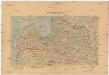
Latwijas Karte
1 : 800000 Lotyšsko Armijas Wirspawehlneeka Schtaba Topografijas
Mapa narodowościowa polskich kresów północno-wschodnich i Litwy
1 : 1000000 Litva Machlejd, Jerzy Zaborski, Bogdan Gebethner & Wolff
Paasche's Frontenkarte, Nr.10. Der Krieg gegen Russland

Übersichtskarte von Mittel - Europa

Übersichtskarte von Mittel - Europa

Lettland
1 : 420000 Lotyšsko Endzelin, J. Karthographischen Institut A. Ošinš & P. Mantnieks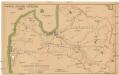
Latwijas dselsszełu schematiska karte
1 : 665000 Lotyšsko Jaunsems, B.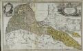
Per illustribus, generosissimis magnificis & excellentissimis dominis, dominis dvcatvvm Cvrlandiæ & Semgalliæ quatuor consiliariis supremis tabulam hanc dvcatvvm Cvrlandiæ & Semgalliæ geographicam
1 Karte : Kupferdruck ; 48 x 44 cm Barnickel Homännische Erben
Per illustribus, generosissimis magnificis & excellentissimis dominis, dominis dvcatvvm Cvrlandiæ & Semgalliæ quatuor consiliariis supremis tabulam hanc dvcatvvm Cvrlandiæ & Semgalliæ geographicam
1 Karte : Kupferdruck ; 48 x 44 cm Barnickel Homännische Erben
Perillustribus generosissimis magnificis & excelentissimis dominis dominis dvcatvvm Cvrlandiae & Semgalliae quatuor consiliaris supremis tabulam hanc dvcatvvm Cvrlandiae & Semgalliae
1 : 142000 Kuronsko Barnikel, Johannes Christoph Homanniani Heredes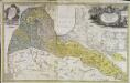
Dvcatvs Cvrlandiæ jux.ta Barnikelii architecti curici primarii geometricam delineationem geographica tabula expressus
1 Karte : Kupferdruck ; 47 x 34 cm Barnickel Homännische Erben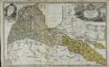
Dvcatvs Cvrlandiæ jux.ta Barnikelii architecti curici primarii geometricam delineationem geographica tabula expressus
1 Karte : Kupferdruck ; 48 x 34 cm Barnickel Homännische Erben
Generalkarte von Zentraleuropa

Kowno 9, uit: Special-Karte von Mittel-Europa / nach amtlichen Quellen bearbeitet von W. Liebenow
1 : 300000 titelvariant: W. Liebenow's Mittel-Europa; Annotatie: Titel boven de bladen: W. Liebenow's Mittel-Europa Johannes Wilhelm Liebenow 1822-1897 Frankfurt a. M. : Ludwig Ravenstein

Ost-See Provinzen.
1 : 1370000 Grassl, J. (Joseph)