Maps of Lithuania

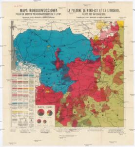
Mapa narodowościowa polskich kresów północno-wschodnich i Litwy
1 : 1000000 Litva Machlejd, Jerzy Zaborski, Bogdan Gebethner & Wolff
[Litauen, Lettland]
Litauen, Lettland, ethnische Gruppe
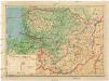
Ethnographische Karte von Litauen
1 : 2000000 Litauen Ethnische Gruppe Kettler, Julius Iwan (red.)
Verwaltungsgebiet Ober Ost. Einteilung der Kreise und Eisenbahnlinien
Baltikum Oberost Weltkrieg <1914-1918> Eisenbahnnetz
Verwaltungsgebiet Ober Ost und geschlossene Sprachgebiete
Baltikum Oberost Weltkrieg <1914-1918>
Kartenskizze des polnisch-weißrussischen Grenzgebietes
Polen Weißrussland Grenzgebiet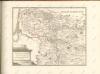
Lietuvos žemelapis
1 : 200000 Litva Spaudos fondas
Paasche's Frontenkarte, Nr.10. Der Krieg gegen Russland

[Lietuvos žemelapis]
Litva
Raspoloženīe 1 i 2 armīi pered vojnoju.
Litauen Weißrussland Napoleonische Kriege
Wiłkomierz, Dwinsk (Dünaburg), Wilna, Wilejka, Słonim, Mińsk
1 : 300000 Minsk (Bělorusko : oblast)
Plan einer trigonometrischen Ausmessung welche in den Jahren 1796 und 1797 in Ostpreussen und Lithauen ausgeführt worden
1 : 800000 Landes-Industrie-Comptoir
Übersichtskarte von Mittel - Europa

Übersichtskarte von Mittel - Europa

Dwinsk (Dünaburg), Friedrichstadt
1 : 750000 Dokšycy (Bělorusko) K. u. k. Militärgeographisches Institut
Trigonometrisk grunnlag, vedlegg 65, 6-9: Grunnlagspunkter for Struves meridianbue fra Vilnius, Hrodna og Kurland
1 : 200000 de Tenner
Nr. 21a. Weitere Ergebnisse der Winterschlacht in Masuren
Masuren Weltkrieg <1914-1918>, Ostfront
Winterschlacht in Masuren
1 : 2000000 Masuren Schlacht, Weltkrieg <1914-1918>
Generalkarte von Zentraleuropa

Potentissimo BORUSSORUM REGI FRIDERICO WILHELMO, Majestate, Fortitudine Clementia Augustissimo
1 : 200000 Kaliningrad-oblast (Rusko) Betgen, Johann F. Homanniani Heredes
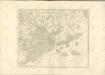
Nowogródek

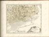
[Vilnius a okolí]
1 : 38000 Vilnius-oblast (Litva) Frolov
Schlacht an den Masurischen Seen
1 : 1000000 Masuren Schlacht, Weltkrieg <1914-1918>
29 Augustowo, uit: Special-Karte von Mittel-Europa / nach amtlichen Quellen bearbeitet von W. Liebenow
1 : 300000 titelvariant: W. Liebenow's Mittel-Europa; Annotatie: Titel boven de bladen: W. Liebenow's Mittel-Europa Johannes Wilhelm Liebenow 1822-1897 Frankfurt a. M. : Ludwig Ravenstein
Schawli 7, uit: Special-Karte von Mittel-Europa / nach amtlichen Quellen bearbeitet von W. Liebenow
1 : 300000 titelvariant: W. Liebenow's Mittel-Europa; Annotatie: Titel boven de bladen: W. Liebenow's Mittel-Europa Johannes Wilhelm Liebenow 1822-1897 Frankfurt a. M. : Ludwig Ravenstein
Kowno 9, uit: Special-Karte von Mittel-Europa / nach amtlichen Quellen bearbeitet von W. Liebenow
1 : 300000 titelvariant: W. Liebenow's Mittel-Europa; Annotatie: Titel boven de bladen: W. Liebenow's Mittel-Europa Johannes Wilhelm Liebenow 1822-1897 Frankfurt a. M. : Ludwig Ravenstein