Maps of Hesse
Electoratus Moguntinus...

Avstrasiorvm sive Franciae orientalis dvcatvs cvm pago Thvringiae avstralis, in svos pagos singvlares svb imperatoribvs Francicis et Saxonicis ex variis medii aevi diplomatibvs chartis ac docvmentis descriptvs
Durynsko (Německo)
Der Frænkische Kreis
1 Karte : Kupferdruck ; 22 x 24 cm Reilly F. J. J. von Reilly
Franconia
1 Karte : Kupferdruck ; 28 x 36 cm Sandrart Jakob von Sandrart
Franconia
1 Karte : Kupferdruck ; 28 x 37 cm Merian
Circulus Franconicus
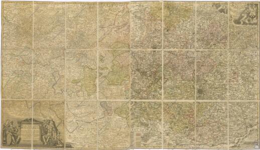
1 Karte : Kupferdruck ; 47 x 57 cm Valck; Valck Valck
Der Fraenkische Kreis
1 : 530000 Franky (Německo) Güssefeld, Franz L. bey denen Homaennischen Erben
Der Fraenkische Kreis
1 : 530000 Franky (Německo) Güssefeld, Franz L. Schmidt, I. M. bey denen Homaennischen Erben
Der Fraenkische Kreis
1 : 530000 Franky (Německo) Güssefeld, Franz L. Schmidt, I. M. Homaennischen Erben
Der Fraenkische Kreis
1 : 530000 Franky (Německo) Güssefeld, Franz L. Schmidt, I. M. bey denen Homaennischen Erben
Circuli Franconiae pars occidentalis, exhibiens simul integrum fere electoratum Moguntinum
1 : 427000 Ansbach (Německo) Homann, Johann Baptist Schönborn, Lothar Franz von Io. Bapt. Homann
Franconia, Neue verbesserte Carten des Gantzen Fränkischen Kraÿses
1 : 740000 Mollova mapová sbírka Merian, Matthaeus Sandrart, Jakob von Sandrart, Jacob von
Franconia, Newe Carten Des Gantzen Fränckischen Krayses
1 : 740000 Mollova mapová sbírka Merian, Matthaeus Merian, Matthäus
Le Cercle De Franconie subdivisé entous les Estats qui le composent [Karte], in: Atlas nouveau, contenant toutes les parties du monde [...], Bd. 1, S. 275.
1 Karte aus Atlas Sanson, Nicolas Jaillot, Alexis Hubert und Mortier, Pieter
Circulus Franconicus
1 : 630000 Mollova mapová sbírka Danckerts, Theodorus Danckerts, Theodor
Charte von dem nordwestlichen Theile des Königreichs Bayern, dem Grossherzogthume Würzburg, dem Fürstenthume Aschaffenburg [et]c.c., oder der Maÿn
1 Karte : Kupferdruck ; 43 x 51 cm Kreibich im Verlage des Geographischen Instituts
Le Cercle de Franconie
1 : 600000 Mollova mapová sbírka Jaillot, Alexis-Hubert Ottens, Josua
Le Cercle de Franconie
1 : 600000 Mollova mapová sbírka Jaillot, Alexis-Hubert Jaillot, Alexis Hubert
Le cercle de Franconie
1 Karte : Kupferdruck ; 44 x 59 cm Jaillot; Ottens; Ottens chez R. et J. Ottens
Le cercle de Franconie
1 Karte : Kupferdruck ; 44 x 59 cm Jaillot Alexis-Hubert Jaillot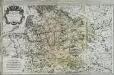
Le cercle de Franconie
1 Karte auf 2 Blatt : Kupferdruck ; 53 x 85 cm Jaillot; Sanson; Chauveau chez H. Iaillot joignant les grands Augustins aux deux globes
Charte von Franken
1 Karte : Kupferdruck ; 43 x 51 cm Kreibich im Verlage des Geographischen Instituts
Der Frænkische Kreis nebst den angraenzenden Laendern
1 Karte : Kupferdruck ; 59 x 69 cm Hammer; Lochner im Verlag der kaiserlich privilegierten Homännischen Handlung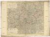
Der Fraenkische Kreis nebst den angraenzenden Laendern
1 : 350000 Franky (Německo) Hammer, C. F. Lochner, Carl Frid. im Verlag der kaiserlich privilegirten Hommanischen Handlung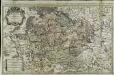
Le cercle de Franconie
1 Karte auf 2 Blatt : Kupferdruck ; 52 x 84 cm Jaillot; Sanson chez H. Iaillot joignant les grands Augustins aux deux globes
Fränkischer Kreis
Allgemeiner Atlas [Walch, Johannes] im Verlag bei Johannes Walch
Charte vom Fränkischen Kreise
1 Karte : Kupferdruck ; 44 x 53 cm Güssefeld im Verlage des Industrie-Comptoirs
Circulus Franconicus
1 Karte : Kupferdruck ; 47 x 56 cm Wit Frederick de Wit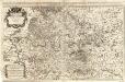
Circulus Franconiae
1 : 500000 Mollova mapová sbírka Hoffmann, Johannes Recknagel, B. Hofmann, Johann