Maps of Stirling

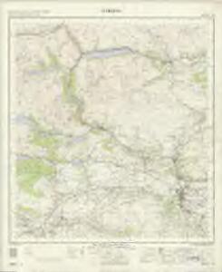
Stirling - OS One-Inch Map
1 : 63360 Topographic maps Ordnance Survey Ordnance Survey
Trossachs, Loch Lomond - Bartholomew's 'Survey Atlas of Scotland'
1 : 126720 Topographic maps John Bartholomew & Son, Ltd John Bartholomew & Son, Ltd
A Mape of the countries about Stirling / authore Jo. Adair.
Adair, John, ca. 1650-1722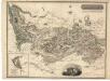
Stirlingshire.
Thomson, John, 1777- ca. 1840 Johnson, William, fl. 1806-1840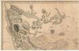
To the Noblemen and Gentlemen of the County of Stirling...
Grassom, John, fl. 1817-1819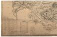
To the Noblemen and Gentlemen of the County of Stirling...
Grassom, John, fl. 1817-1819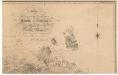
To the Noblemen and Gentlemen of the County of Stirling...
Grassom, John, fl. 1817-1819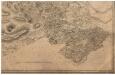
To the Noblemen and Gentlemen of the County of Stirling...
Grassom, John, fl. 1817-1819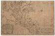
A map of the Shire of Dumbarton.
Ross, Charles, 1722-1806
A map of the Shire of Dumbarton.
Ross, Charles, 1722-1806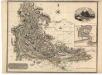
Dumbartonshire.
Thomson, John, 1777- ca. 1840
Loch Katrine & Loch Earn (62) - OS One-Inch map
1 : 63360 Topographic maps Ordnance Survey Ordnance Survey
Loch Katrine & Loch Earn (62) - OS One-Inch map
1 : 63360 Topographic maps Ordnance Survey Ordnance Survey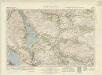
Loch Lomond (66) - OS One-Inch map
1 : 63360 Topographic maps Ordnance Survey Ordnance Survey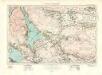
Loch Lomond (66) - OS One-Inch map
1 : 63360 Topographic maps Ordnance Survey Ordnance Survey
Stirling - OS One-Inch map
1 : 63360 Topographic maps Ordnance Survey Ordnance Survey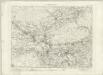
Stirling - OS One-Inch map
1 : 63360 Topographic maps Ordnance Survey Ordnance Survey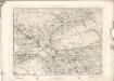
Stirling - OS One-Inch map
1 : 63360 Topographic maps Ordnance Survey Ordnance Survey
Loch Lomond - OS One-Inch map
1 : 63360 Topographic maps Ordnance Survey Ordnance Survey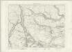
Loch Lomond - OS One-Inch map
1 : 63360 Topographic maps Ordnance Survey Ordnance Survey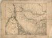
Loch Lomond - OS One-Inch map
1 : 63360 Topographic maps Ordnance Survey Ordnance Survey
Volume 1: Sheet 38 - Loch Lomond
1 : 63360 Farquharson, J.
NN50 - OS 1:25,000 Provisional Series Map
1 : 25000 Topographic maps Ordnance Survey Ordnance Survey
NS59 - OS 1:25,000 Provisional Series Map
1 : 25000 Topographic maps Ordnance Survey Ordnance Survey
NS58 - OS 1:25,000 Provisional Series Map
1 : 25000 Topographic maps Ordnance Survey Ordnance Survey
NN60 - OS 1:25,000 Provisional Series Map
1 : 25000 Topographic maps Ordnance Survey Ordnance Survey
NS69 - OS 1:25,000 Provisional Series Map
1 : 25000 Topographic maps Ordnance Survey Ordnance Survey
NS68 - OS 1:25,000 Provisional Series Map
1 : 25000 Topographic maps Ordnance Survey Ordnance Survey
NN70 - OS 1:25,000 Provisional Series Map
1 : 25000 Topographic maps Ordnance Survey Ordnance Survey