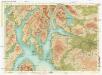
Maps of Argyll and Bute

Nieuwe Caart van de Rivier van Glasgow in 't Groot.
Keulen, Johannes van, 1654-1715
delineation of the strata of England and Wales, with part of Scotland
1 : 320000 Blatt 1 Smith, William Cary
Scotland[Motoring Map of]
London : "Geographia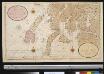
Nieuwe afteekening van de West kust van SchotLand als ook de eijlanden van Jura, Collensa, IJla, Cantijra en Arren
Great-Britain Gerard van Keulen
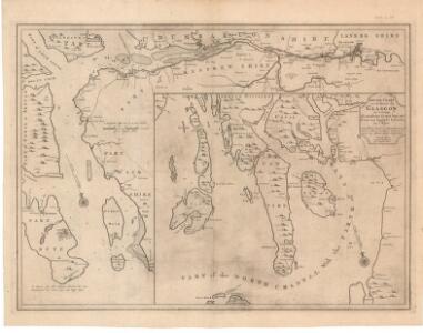
A new and exact map of the River Clyde done by the late Mr. John Adair / now publish'd for the good of the publick by Geo. Scott.
Adair, John, ca. 1650-1722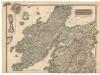
Northern Part of Argyll Shire.
Thomson, John, 1777- ca. 1840 Johnson, William, fl. 1806-1840
Southern Part of Argyll Shire.
Thomson, John, 1777- ca. 1840 Johnson, William, fl. 1806-1840
A map of such part of his Grace the Duke of Argyle's heritable dukedom, and justiciary territories, islands, superiorities & jurisdictions as lye contiguous upon the western Coast of North Britain
Cowley, J. (John)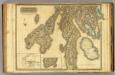
Argyllshire N.
1 : 175000 Thomson, John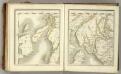
Sheets 73-74. (Cary's England, Wales, and Scotland).
1 : 360000 Cary, John, ca. 1754-1835
Composite: Argyllshire.
1 : 175000 Thomson, John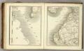
Sheets 64-65. (Cary's England, Wales, and Scotland).
1 : 360000 Cary, John, ca. 1754-1835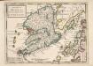
The Isle of Mull &c. Part of Argyle Shire / by H. Moll.
Moll, Herman, d. 1732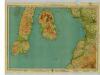
Arran & Lower Clyde, Sheet 3 - Bartholomew's "Half Inch to the Mile Maps" of Scotland
1 : 126720 Topographic maps John Bartholomew & Son, Ltd John Bartholomew & Son, Ltd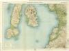
Arran & Lower Clyde, Sheet 3 - Bartholomew's "Half Inch to the Mile Maps" of Scotland
1 : 126720 Topographic maps Bartholomew, John George John Bartholomew & Co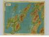
Islay & Jura, Sheet 6 - Bartholomew's "Half Inch to the Mile Maps" of Scotland
1 : 126720 Topographic maps John Bartholomew & Son, Ltd John Bartholomew & Son, Ltd
Islay, Jura, Colonsay, Sheet 6 - Bartholomew's "Half Inch to the Mile Maps" of Scotland
1 : 126720 Topographic maps Bartholomew, John George John Bartholomew & Co
Islay, Jura, Colonsay &c.
Great Britain. Hydrographic Office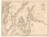
The Clyde, Loch Fyne &c.
Great Britain. Hydrographic Office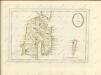
The Shire of Bute : contains Bute and Arran with Cantire [i.e. Kintyre] which is Part of Argyle Shire / by H. Moll.
Moll, Herman, d. 1732
Firth of Clyde, Sheet 7 - Bartholomew's "Half Inch to the Mile Maps" of Scotland
1 : 126720 Topographic maps John Bartholomew & Son, Ltd John Bartholomew & Son, Ltd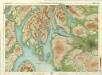
Glasgow & Clyde, Sheet 7 - Bartholomew's "Half Inch to the Mile Maps" of Scotland
1 : 126720 Topographic maps Bartholomew, John George John Bartholomew & Co
Ila insvla
1 Karte : Kupferdruck ; 53 x 51 cm Blaeu; Pont Joan Blaeu
CANTYRA | Chersonesus, | CANTYR | a Demie-yland
Auctor Timoth. Pont. [Amsterdam : Joan Blaeu]
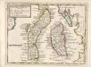
ARANIA | Insula in æstuario Glottæ | THE YLE OF ARREN | in the Fyrth of Clyd
Timotheo Pont Auctore. [Amsterdam : Joan Blaeu]
ILA INSVLA, | ex Æbudarum majoribus una. | THE YLE OF ILA, | being one of the biggest of the Westerne Yles.
Auct. Tim. Pont. [Amsterdam : Joan Blaeu]
Cantyra chersonesus
1 Karte : Kupferdruck ; 40 x 48 cm Blaeu; Pont Joan Blaeu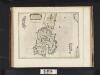
Ila Insula ex Aebudarum majoribus una, The Yle of Ila being one of the biggest of the Westerne Yles. / Auct. Tim. Pont.
Pont, Timothy, 1560?-1614? Blaeu, Joan, 1596-1673