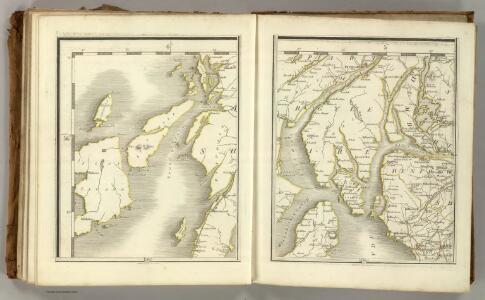
Maps of North Ayshire
Sheets 73-74. (Cary's England, Wales, and Scotland).
1 : 360000 Cary, John, ca. 1754-1835
Argyllshire N.
1 : 175000 Thomson, John
The Clyde, Loch Fyne &c.
Great Britain. Hydrographic Office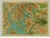
Firth of Clyde, Sheet 7 - Bartholomew's "Half Inch to the Mile Maps" of Scotland
1 : 126720 Topographic maps John Bartholomew & Son, Ltd John Bartholomew & Son, Ltd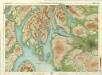
Glasgow & Clyde, Sheet 7 - Bartholomew's "Half Inch to the Mile Maps" of Scotland
1 : 126720 Topographic maps Bartholomew, John George John Bartholomew & Co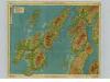
Islay & Jura, Sheet 6 - Bartholomew's "Half Inch to the Mile Maps" of Scotland
1 : 126720 Topographic maps John Bartholomew & Son, Ltd John Bartholomew & Son, Ltd
Islay, Jura, Colonsay, Sheet 6 - Bartholomew's "Half Inch to the Mile Maps" of Scotland
1 : 126720 Topographic maps Bartholomew, John George John Bartholomew & Co
Bute and Arran - Bartholomew's 'Survey Atlas of Scotland'
1 : 126720 Topographic maps John Bartholomew & Son, Ltd John Bartholomew & Son, Ltd
IVRA INSVLA | The Yle of IVRA | one of the westerne Iles | of SCOTLAND.
Auct. Timoth. Pont. [Amsterdam : Joan Blaeu]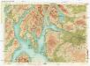
Bartholomew's "Half-inch to mile" map of Scotland
1 : 204000 Skotsko Geographical Institute
Knapdalia provincia, que sub Argathelia censetur
1 Karte : Kupferdruck ; 41 x 52 cm Blaeu; Pont Joan Blaeu
Firth of Clyde - OS One-Inch Map
1 : 63360 Topographic maps Ordnance Survey Ordnance Survey
Knapdale - OS One-Inch Map
1 : 63360 Topographic maps Ordnance Survey Ordnance Survey
KNAPDALIA | PROVINCIA, | que sub Argathelia censetur. | The Province of KNAPDAIL | which is accounted a member of Argyll.
Auct. Timoth. Pont. [Amsterdam : Joan Blaeu]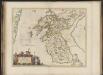
Knapdalia Provincia que sub Argathelia censetur, [vel], The Province of Knapdail which is accounted a member of Argyll. Auct. Timoth. Pont.
Pont, Timothy, 1560?-1614? Blaeu, Joan, 1596-1673
Loch Fyne
Great Britain. Hydrographic Office
Buthe insula vulgo the yle of Boot
1 Karte : Kupferdruck ; 38 x 49 cm Blaeu; Pont Joan Blaeu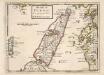
The Isle of Iura &c. Part of Argyle Shire / by H. Moll.
Moll, Herman, d. 1732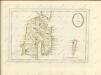
Iura Insula, The Yle of Iura one of the westerne Iles of Scotland / Auct. Timoth. Pont.
Pont, Timothy, 1560?-1614? Blaeu, Joan, 1596-1673
Ila insvla
1 Karte : Kupferdruck ; 53 x 51 cm Blaeu; Pont Joan Blaeu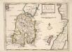
The Isle of Ila &c. Part of Argyle Shire / by H. Moll.
Moll, Herman, d. 1732
Ivra insvla
1 Karte : Kupferdruck ; 40 x 51 cm Blaeu; Pont Joan Blaeu
Ports And Harbours On The West Coast of Scotland.
Fullarton, A. & Co.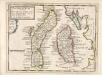
The Shire of Bute : contains Bute and Arran with Cantire [i.e. Kintyre] which is Part of Argyle Shire / by H. Moll.
Moll, Herman, d. 1732
Ila Insula ex Aebudarum majoribus una, The Yle of Ila being one of the biggest of the Westerne Yles. / Auct. Tim. Pont.
Pont, Timothy, 1560?-1614? Blaeu, Joan, 1596-1673
ILA INSVLA, | ex Æbudarum majoribus una. | THE YLE OF ILA, | being one of the biggest of the Westerne Yles.
Auct. Tim. Pont. [Amsterdam : Joan Blaeu]
Island of Bute (71) - OS One-Inch map
1 : 63360 Topographic maps Ordnance Survey Ordnance Survey
Island of Bute (71) - OS One-Inch map
1 : 63360 Topographic maps Ordnance Survey Ordnance Survey
Sound of Jura (70) - OS One-Inch map
1 : 63360 Topographic maps Ordnance Survey Ordnance Survey