Maps of Argyll and Bute

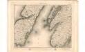
Islay, Jura, Colonsay &c.
Great Britain. Hydrographic Office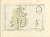

Ila insvla
1 Karte : Kupferdruck ; 53 x 51 cm Blaeu; Pont Joan Blaeu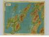
Islay & Jura, Sheet 6 - Bartholomew's "Half Inch to the Mile Maps" of Scotland
1 : 126720 Topographic maps John Bartholomew & Son, Ltd John Bartholomew & Son, Ltd
Islay, Jura, Colonsay, Sheet 6 - Bartholomew's "Half Inch to the Mile Maps" of Scotland
1 : 126720 Topographic maps Bartholomew, John George John Bartholomew & Co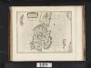
Ila Insula ex Aebudarum majoribus una, The Yle of Ila being one of the biggest of the Westerne Yles. / Auct. Tim. Pont.
Pont, Timothy, 1560?-1614? Blaeu, Joan, 1596-1673
ILA INSVLA, | ex Æbudarum majoribus una. | THE YLE OF ILA, | being one of the biggest of the Westerne Yles.
Auct. Tim. Pont. [Amsterdam : Joan Blaeu]
Islay - OS One-Inch Map
1 : 63360 Topographic maps Ordnance Survey Ordnance Survey
Islay - Bartholomew's 'Survey Atlas of Scotland'
1 : 126720 Topographic maps John Bartholomew & Son, Ltd John Bartholomew & Son, Ltd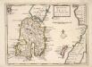
The Isle of Ila &c. Part of Argyle Shire / by H. Moll.
Moll, Herman, d. 1732
IVRA INSVLA | The Yle of IVRA | one of the westerne Iles | of SCOTLAND.
Auct. Timoth. Pont. [Amsterdam : Joan Blaeu]
Ivra insvla
1 Karte : Kupferdruck ; 40 x 51 cm Blaeu; Pont Joan Blaeu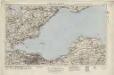
Islay (69) - OS One-Inch map
1 : 63360 Topographic maps Ordnance Survey Ordnance Survey
Islay (69) - OS One-Inch map
1 : 63360 Topographic maps Ordnance Survey Ordnance Survey
Iura Insula, The Yle of Iura one of the westerne Iles of Scotland / Auct. Timoth. Pont.
Pont, Timothy, 1560?-1614? Blaeu, Joan, 1596-1673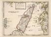
The Isle of Iura &c. Part of Argyle Shire / by H. Moll.
Moll, Herman, d. 1732
Portascaig - OS One-Inch map
1 : 63360 Topographic maps Ordnance Survey Ordnance Survey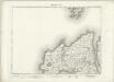
Portascaig - OS One-Inch map
1 : 63360 Topographic maps Ordnance Survey Ordnance Survey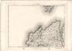
Portascaig - OS One-Inch map
1 : 63360 Topographic maps Ordnance Survey Ordnance Survey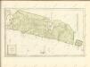

Bowmore - OS One-Inch map
1 : 63360 Topographic maps Ordnance Survey Ordnance Survey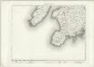
Bowmore - OS One-Inch map
1 : 63360 Topographic maps Ordnance Survey Ordnance Survey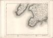
Bowmore - OS One-Inch map
1 : 63360 Topographic maps Ordnance Survey Ordnance Survey
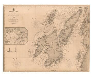
Colonsay and Oronsay
Great Britain. Hydrographic Office
Sound of Islay
Great Britain. Hydrographic Office
Sound of Jura (70) - OS One-Inch map
1 : 63360 Topographic maps Ordnance Survey Ordnance Survey
Sound of Jura (70) - OS One-Inch map
1 : 63360 Topographic maps Ordnance Survey Ordnance Survey
Jura - OS One-Inch map
1 : 63360 Topographic maps Ordnance Survey Ordnance Survey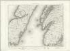
Jura - OS One-Inch map
1 : 63360 Topographic maps Ordnance Survey Ordnance Survey