Maps of Newcastle-under-Lyme
Staffordshire XXIX.4 (includes: Eccleshall; Swynnerton) - 25 Inch Map
1 : 2500 Topographic maps Ordnance Survey Ordnance Survey
Staffordshire XXIX.4 (includes: Eccleshall; Swynnerton) - 25 Inch Map
1 : 2500 Topographic maps Ordnance Survey Ordnance Survey
Staffordshire XXIX.4 (includes: Eccleshall; Swynnerton) - 25 Inch Map
1 : 2500 Topographic maps Ordnance Survey Ordnance Survey
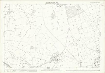
Staffordshire XXIX.NE - OS Six-Inch Map
1 : 10560 Topographic maps Ordnance Survey Ordnance Survey
Staffordshire XXIX.NE - OS Six-Inch Map
1 : 10560 Topographic maps Ordnance Survey Ordnance Survey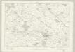
Staffordshire XXIX - OS Six-Inch Map
1 : 10560 Topographic maps Ordnance Survey Ordnance Survey
SJ83 - OS 1:25,000 Provisional Series Map
1 : 25000 Topographic maps Ordnance Survey Ordnance Survey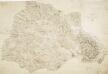
Part of Staffordshire Containing 100 Square Miles Surveyed by Mr Field and Drawn by Mr Stevens 1817
1 : 31680 .This plan of part of Staffordshire shows the Trent and Sow River valleys. The red lines to the right of the,drawing,probably indicate stone walls,,prominent features of the Staffordshire landscape. Stevens, Henry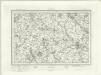
Stafford (Outline) - OS One-Inch Revised New Series
1 : 63360 Topographic maps Ordnance Survey Ordnance Survey
Stafford (Hills) - OS One-Inch Revised New Series
1 : 63360 Topographic maps Ordnance Survey Ordnance Survey
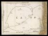
Chartley Park
1 : 31680 A triangulation diagram appears on the reverse of this drawing. This enabled the draughtsman to plot the exact location of topographical features. The drawing lacks any indication of relief, suggesting that it is a 'rough' copy. Stevens, Henry
Stoke on Trent - OS One-Inch Map
1 : 63360 Topographic maps Ordnance Survey Ordnance Survey
Stafford - OS One-Inch Map
1 : 63360 Topographic maps Ordnance Survey Ordnance Survey
An improved map of the county of Stafford
1 Karte : Kupferdruck ; 67 x 51 cm Bowen; Hinton sold by I. Hinton at the Kings Arms in St. Pauls Church Yard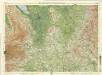
Cheshire, Sheet 12 - Bartholomew's "Half Inch to the Mile Maps" of England & Wales
1 : 126720 Topographic maps Bartholomew, John George John Bartholomew & Co
Staffordiensis comitatvs; vulgo Stafford Shire
1 Karte : Kupferdruck ; 39 x 49 cm Blaeu Joan Blaeu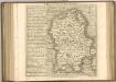
Map of Shropshire f. 75*
This is a manuscript map of Shropshire. It forms part of an atlat which belonged to Lord Burghley, Secretary of State to Elizabeth I, who used it to illustrate domestic matters. It shows only the principal towns, distinguishing between those with a castle and those without by means of a symbol of two connected towers with crenellations. The River Severn, marked Sabrina F, is charted. Lord Burghley has added a name adjacent to a place where the river is bridged. Lord Burghley was concerned with communication routes as revealed by his annotation. The draughtsman has indicated relief by hill symbols in two places. The map features a scale bar, but this is partly obscured by damage to the map.
Comitatvs Darbiensis
1 Karte : Kupferdruck ; 36 x 47 cm Valck; Schenk apud G. Valk et P. Schenk
Cestria Comitatus Palatinus. [Karte], in: Theatrum orbis terrarum, sive, Atlas novus, Bd. 4, S. 381.
1 Karte aus Atlas Blaeu, Joan Blaeu, Willem Janszoon
Cestria Comitatus Palatinus. [Karte], in: Le théâtre du monde, ou, Nouvel atlas contenant les chartes et descriptions de tous les païs de la terre, Bd. 4, S. 329.
1 Karte aus Atlas Blaeu, Willem Janszoon und Blaeu, Joan Blaeu, Willem Janszoon
Sheets 40-41. (Cary's England, Wales, and Scotland).
1 : 360000 Cary, John, ca. 1754-1835
The Countye Palatine Of Chester Comitatus Cestrensis. [Karte], in: Gerardi Mercatoris et I. Hondii Newer Atlas, oder, Grosses Weltbuch, Bd. 1, S. 81.
1 Karte aus Atlas Mercator, Gerhard und Hondius, Jodocus Jansson, Jan
Cestria Comitatus Palantinus. The Countye Palatine of Chester. [Karte], in: Novus atlas absolutissimus, Bd. 7, S. 364.
1 Karte aus Atlas Janssonius Offizin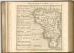

DARBIENSIS | COMITATVS. | Vernacule | DARBIE SHIRE
[Amsterdam : Joan Blaeu]
Comitatus Darbiensis
1 : 240000 [Amstelodami] : [apud Joannem Janssonium]

COMITATVS | SALOPIENSIS; | Anglice | SHROP SHIRE.
[Amsterdam : Joan Blaeu]