Maps of East Lindsey

Lincolnshire LXXV.SE - OS Six-Inch Map
1 : 10560 Topographic maps Ordnance Survey Ordnance Survey
Lincolnshire LXXV.SE - OS Six-Inch Map
1 : 10560 Topographic maps Ordnance Survey Ordnance Survey
Lincolnshire LXXV.SE - OS Six-Inch Map
1 : 10560 Topographic maps Ordnance Survey Ordnance Survey
Lincolnshire LXXV.SE - OS Six-Inch Map
1 : 10560 Topographic maps Ordnance Survey Ordnance Survey
Lincolnshire LXXV.12 (includes: Welton Le Marsh; Willoughby and Sloothby) - 25 Inch Map
1 : 2500 Topographic maps Ordnance Survey Ordnance Survey
Lincolnshire LXXV.12 (includes: Welton Le Marsh; Willoughby and Sloothby) - 25 Inch Map
1 : 2500 Topographic maps Ordnance Survey Ordnance Survey
Lincolnshire LXXV.16 (includes: Orby; Welton Le Marsh; Willoughby and Sloothby) - 25 Inch Map
1 : 2500 Topographic maps Ordnance Survey Ordnance Survey
Lincolnshire LXXV.16 (includes: Orby; Welton Le Marsh; Willoughby and Sloothby) - 25 Inch Map
1 : 2500 Topographic maps Ordnance Survey Ordnance Survey
Lincolnshire LXXV.15 (includes: Candlesby; Welton Le Marsh) - 25 Inch Map
1 : 2500 Topographic maps Ordnance Survey Ordnance Survey
Lincolnshire LXXV.15 (includes: Candlesby; Welton Le Marsh) - 25 Inch Map
1 : 2500 Topographic maps Ordnance Survey Ordnance Survey
Lincolnshire LXXV.11 (includes: Claxby; Welton Le Marsh; Willoughby and Sloothby) - 25 Inch Map
1 : 2500 Topographic maps Ordnance Survey Ordnance Survey
Lincolnshire LXXV.11 (includes: Claxby; Welton Le Marsh; Willoughby and Sloothby) - 25 Inch Map
1 : 2500 Topographic maps Ordnance Survey Ordnance Survey
TF46 - OS 1:25,000 Provisional Series Map
1 : 25000 Topographic maps Ordnance Survey Ordnance Survey
Alford
1 : 31680 This plan covers an area of Lincolnshire from Thrustorpe in the north to Skegness in the south. Sandy beaches, characteristic of the coastline, are represented by banks of yellow dots on a paler yellow wash. The locations of various hotels are indicated along the coast. Further inland, symbols formed of three vertically inclined strokes above a short horizontal line are used to indicate salt marshes. Stevens, H.
Skegness (Hills) - OS One-Inch Revised New Series
1 : 63360 Topographic maps Ordnance Survey Ordnance Survey
Skegness (Outline) - OS One-Inch Revised New Series
1 : 63360 Topographic maps Ordnance Survey Ordnance Survey
Boston and Skegness - OS One-Inch Map
1 : 63360 Topographic maps Ordnance Survey Ordnance Survey
Grimsby - OS One-Inch Map
1 : 63360 Topographic maps Ordnance Survey Ordnance Survey
Lincoln Fens, Sheet 14 - Bartholomew's "Half Inch to the Mile Maps" of England & Wales
1 : 126720 Topographic maps Bartholomew, John George John Bartholomew & Co
Sheets 42-43. (Cary's England, Wales, and Scotland).
1 : 360000 Cary, John, ca. 1754-1835
Lincolnia comitatus : Anglis Lincoln-Shire
1 : 253000
An accurate map of Lincolnshire
1 Karte : Kupferdruck ; 68 x 51 cm Bowen; Hinton sold by J. Hinton at the Kings Arms in St. Pauls Church Yard
Lincolnia comitatvs anglis Lincoln-Shire
1 Karte : Kupferdruck ; 40 x 48 cm Blaeu Joan Blaeu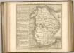

Norfolciae Descriptio. The Description of Norfolk. [Karte], in: Gerardi Mercatoris et I. Hondii Newer Atlas, oder, Grosses Weltbuch, Bd. 1, S. 90.
1 Karte aus Atlas Mercator, Gerhard und Hondius, Jodocus Jansson, Jan
Nortfolcia; Norfolke. [Karte], in: Le théâtre du monde, ou, Nouvel atlas contenant les chartes et descriptions de tous les païs de la terre, Bd. 4, S. 260.
1 Karte aus Atlas Blaeu, Willem Janszoon und Blaeu, Joan Blaeu, Willem Janszoon
Nortfolcia; Norfolke. [Karte], in: Theatrum orbis terrarum, sive, Atlas novus, Bd. 4, S. 296.
1 Karte aus Atlas Blaeu, Joan Blaeu, Willem Janszoon
Nortfolcia; Norfolke. [Karte], in: Theatrum orbis terrarum, sive, Atlas novus, Bd. 4, S. 296.
1 Karte aus Atlas Blaeu, Joan Blaeu, Willem Janszoon
Nortfolcia; vernacule Norfolke. [Karte], in: Novus atlas absolutissimus, Bd. 7, S. 285.
1 Karte aus Atlas Janssonius Offizin


