Maps of Norfolk

Norfolk XVI.SW - OS Six-Inch Map
1 : 10560 Topographic maps Ordnance Survey Ordnance Survey
Norfolk XVI.SW - OS Six-Inch Map
1 : 10560 Topographic maps Ordnance Survey Ordnance Survey
Norfolk XVI.SW - OS Six-Inch Map
1 : 10560 Topographic maps Ordnance Survey Ordnance Survey
Norfolk XVI.SW - OS Six-Inch Map
1 : 10560 Topographic maps Ordnance Survey Ordnance Survey
Norfolk XVI.14 (includes: Barsham; Fakenham; Sculthorpe) - 25 Inch Map
1 : 2500 Topographic maps Ordnance Survey Ordnance Survey
Norfolk XVI.14 (includes: Barsham; Fakenham; Sculthorpe) - 25 Inch Map
1 : 2500 Topographic maps Ordnance Survey Ordnance Survey
Norfolk XVI.10 (includes: Barsham) - 25 Inch Map
1 : 2500 Topographic maps Ordnance Survey Ordnance Survey
Norfolk XVI.10 (includes: Barsham) - 25 Inch Map
1 : 2500 Topographic maps Ordnance Survey Ordnance Survey
Norfolk XVI.13 (includes: Barsham; Dunton; Sculthorpe; South Creake) - 25 Inch Map
1 : 2500 Topographic maps Ordnance Survey Ordnance Survey
Norfolk XVI.13 (includes: Barsham; Dunton; Sculthorpe; South Creake) - 25 Inch Map
1 : 2500 Topographic maps Ordnance Survey Ordnance Survey
Norfolk XVI.9 (includes: Barsham; Sculthorpe; South Creake) - 25 Inch Map
1 : 2500 Topographic maps Ordnance Survey Ordnance Survey
Norfolk XVI.9 (includes: Barsham; Sculthorpe; South Creake) - 25 Inch Map
1 : 2500 Topographic maps Ordnance Survey Ordnance Survey
TF83 - OS 1:25,000 Provisional Series Map
1 : 25000 Topographic maps Ordnance Survey Ordnance Survey
TF93 - OS 1:25,000 Provisional Series Map
1 : 25000 Topographic maps Ordnance Survey Ordnance Survey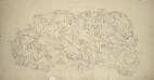
Fakenham
1 : 31680 This plan covers north-west Norfolk, an area characterised by arable and grassland interspersed with mixed woodland. Rainham Park at lower right and Melton Park in the centre are good examples of 18th-century formal gardens. Isolated villages and dispersed farms represent the dominant settlement pattern in an area made up of large private estates. Metcalf, Edward B.
Fakenham (Outline) - OS One-Inch Revised New Series
1 : 63360 Topographic maps Ordnance Survey Ordnance Survey
Fakenham (Hills) - OS One-Inch Revised New Series
1 : 63360 Topographic maps Ordnance Survey Ordnance Survey
Wells
1 : 31680 This plan covers the North Norfolk coast and features some of the most distinctive salt-marshes, inter-tidal flats, dunes, shingle and grazing marshes in Europe. Near Wells-next-the-Sea is Holkham Park with its triumphal arch indicated along the southern approach. This was the path visitors from London and Newmarket would have taken to Wells. At the highest point of the park, aligned with the arch, is the obelisk of Holkham Park Mansion and Kent's North Lodges. Budgen, Charles
Fakenham - OS One-Inch Map
1 : 63360 Topographic maps Ordnance Survey Ordnance Survey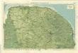
Norfolk, Sheet 15 - Bartholomew's "Half Inch to the Mile Maps" of England & Wales
1 : 126720 Topographic maps Bartholomew, John George John Bartholomew & Co
Sheets 44-45. (Cary's England, Wales, and Scotland).
1 : 360000 Cary, John, ca. 1754-1835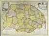
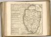
An accurate map of the county of Norfolk
1 Karte : Kupferdruck ; 52 x 70 cm Bowen; Hinton sold by I. Hinton at the Kings Arms in St. Pauls Church yard
Nortfolcia; vernacule Norfolke
1 Karte : Kupferdruck ; 36 x 47 cm Valck; Schenk penes Gerardum Valk et Petrum Schenk
Nortfolcia
1 Karte : Kupferdruck ; 37 x 48 cm Blaeu Joan Blaeu
The Fens
This is a map of the fenlands dating from around 1603. It is thought to be the model for Hondius's "A generall plotte of the Fennes" published in Amsterdam in 1632 and is signed Ro. Cotton. The map shows the area in some detail, generalised representations of churches represent small settlements. Larger towns such as Cambridge and Bury St Edmunds' are shown in more detail with individualised red roofed buildings. The sands or the washes are indicated by dotted lines and a beacon is marked on the sands. A notable feature of the drawing is the proliferation of windmills as the wind from the sea can move inland unhindered by hills.
Cantabrigiensis Comitatus; Cambridge Shire. [Karte], in: Theatrum orbis terrarum, sive, Atlas novus, Bd. 4, S. 306.
1 Karte aus Atlas Blaeu, Joan Blaeu, Willem Janszoon
Cantabrigiensis Comitatus; Cambridge Shire. [Karte], in: Le théâtre du monde, ou, Nouvel atlas contenant les chartes et descriptions de tous les païs de la terre, Bd. 4, S. 270.
1 Karte aus Atlas Blaeu, Willem Janszoon und Blaeu, Joan Blaeu, Willem Janszoon
Cantabrigiensis Comitatus; Cambridge Shire. [Karte], in: Theatrum orbis terrarum, sive, Atlas novus, Bd. 4, S. 306.
1 Karte aus Atlas Blaeu, Joan Blaeu, Willem Janszoon
Comitatis Cantabrigiensis; vernacule Cambridgeshire. [Karte], in: Novus atlas absolutissimus, Bd. 7, S. 294.
1 Karte aus Atlas Janssonius Offizin