Maps of Somerset

Somerset XLVIII.NW - OS Six-Inch Map
1 : 10560 Topographic maps Ordnance Survey Ordnance Survey
Somerset XLVIII.NW - OS Six-Inch Map
1 : 10560 Topographic maps Ordnance Survey Ordnance Survey
Somerset XLVIII.NW - OS Six-Inch Map
1 : 10560 Topographic maps Ordnance Survey Ordnance Survey
Somerset XLVIII.5 (includes: Monksilver; Nettlecombe; Sampford Brett; Stogumber; Williton) - 25 Inch Map
1 : 2500 Topographic maps Ordnance Survey Ordnance Survey
Somerset XLVIII.5 (includes: Monksilver; Nettlecombe; Sampford Brett; Stogumber; Williton) - 25 Inch Map
1 : 2500 Topographic maps Ordnance Survey Ordnance Survey
Somerset XLVIII.5 (includes: Monksilver; Nettlecombe; Sampford Brett; Stogumber; Williton) - 25 Inch Map
1 : 2500 Topographic maps Ordnance Survey Ordnance Survey
Somerset XLVIII.5 (includes: Monksilver; Nettlecombe; Sampford Brett; Stogumber; Williton) - 25 Inch Map
1 : 2500 Topographic maps Ordnance Survey Ordnance Survey
Somerset XLVIII.1 (includes: Old Cleeve; Sampford Brett; Williton) - 25 Inch Map
1 : 2500 Topographic maps Ordnance Survey Ordnance Survey
Somerset XLVIII.1 (includes: Old Cleeve; Sampford Brett; Williton) - 25 Inch Map
1 : 2500 Topographic maps Ordnance Survey Ordnance Survey
Somerset XLVIII.1 (includes: Old Cleeve; Sampford Brett; Williton) - 25 Inch Map
1 : 2500 Topographic maps Ordnance Survey Ordnance Survey
Somerset XLVIII.1 (includes: Old Cleeve; Sampford Brett; Williton) - 25 Inch Map
1 : 2500 Topographic maps Ordnance Survey Ordnance Survey
Somerset XLVIII.2 (includes: Bicknoller; Sampford Brett; West Quantoxhead; Williton) - 25 Inch Map
1 : 2500 Topographic maps Ordnance Survey Ordnance Survey
Somerset XLVIII.2 (includes: Bicknoller; Sampford Brett; West Quantoxhead; Williton) - 25 Inch Map
1 : 2500 Topographic maps Ordnance Survey Ordnance Survey
Somerset XLVIII.2 (includes: Bicknoller; Sampford Brett; West Quantoxhead; Williton) - 25 Inch Map
1 : 2500 Topographic maps Ordnance Survey Ordnance Survey
Somerset XLVIII.2 (includes: Bicknoller; Sampford Brett; West Quantoxhead; Williton) - 25 Inch Map
1 : 2500 Topographic maps Ordnance Survey Ordnance Survey
Somerset XLVIII.6 (includes: Bicknoller; Monksilver; Sampford Brett; Stogumber) - 25 Inch Map
1 : 2500 Topographic maps Ordnance Survey Ordnance Survey
Somerset XLVIII.6 (includes: Bicknoller; Monksilver; Sampford Brett; Stogumber) - 25 Inch Map
1 : 2500 Topographic maps Ordnance Survey Ordnance Survey
Somerset XLVIII.6 (includes: Bicknoller; Monksilver; Sampford Brett; Stogumber) - 25 Inch Map
1 : 2500 Topographic maps Ordnance Survey Ordnance Survey
ST04 - OS 1:25,000 Provisional Series Map
1 : 25000 Topographic maps Ordnance Survey Ordnance Survey
ST03 - OS 1:25,000 Provisional Series Map
1 : 25000 Topographic maps Ordnance Survey Ordnance Survey
Dunster
A section of the English south coast from Dunster to Watchet is covered by this drawing. Sand is indicated by a speckled grey wash, with grey shapes signifying rocks. Although it was not compulsory to include archaeological sites at the time of this map's survey, the draughtsman has noted an iron age settlement near Wiviliscombe as an 'Ancient Camp'. Several quarries are also marked,including a slate quarry at Oakhampton Wood.
Minehead - OS One-Inch Map
1 : 63360 Topographic maps Ordnance Survey Ordnance Survey
Cary's Improved Map of England and Wales
Cary, George, & Cary, John London : G. & J. Cary
North Devon, Sheet 35 - Bartholomew's "Half Inch to the Mile Maps" of England & Wales
1 : 126720 Topographic maps Bartholomew, John George John Bartholomew & Co
An improved map of the county of Somerset
1 Karte : Kupferdruck ; 51 x 68 cm Bowen; Hinton sold by I. Hinton at the Kings Arms in St. Pauls Church Yard
Somersettensis comitatvs
1 Karte : Kupferdruck ; 36 x 48 cm Valck; Schenk apud G. Valk et P. Schenk
Somersettensis comitatvs
1 Karte : Kupferdruck ; 37 x 48 cm Blaeu Joan Blaeu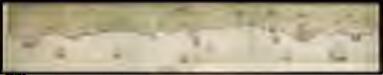
A coloured chart of "The coste of England uppon Severne," being the whole north coast of Somersetshire; with the forts erected thereon; temp. Henry VIII ca. 1540
This is a pictorial representation of the north coast of Somerset. It shows the coast from the mouth of the River Avon near East Bristol to west Porlock and can be dated to 1539. At the top of the drawing round towers represent proposed blockhouses in the neighbourhoods of Porlock and Western-super-Mare on the north coast of Somerset. The intention to mount guns on platforms at Minehead and to the north of the Parrat is also represented in this drawing. Inlets are indicated and towns are shown schematically, an emphasis on the nature of the coast is evident as the draughtsman has recorded outcrops of rocks. The existence of this drawing and the proposals it contains can be imputed the threat of invasion which became probable in 1538 after a peace treaty was signed by Francis I of France and Charles V, Holy Roman Emperor King of Spain. England and France were ancient enemy’s and the Catholic Charles V, nephew of Catherine of Aragon, was angered by Henry VII’s decision to divorce her. In the event, the works proposed here were not carried out. The paper upon which this map is drawn bears a watermark of a double headed eagle bearing a shield.
SOMERSET- | TENSIS | COMITATVS. | Somerset shire.
[Amsterdam : Joan Blaeu]


