Maps of Devon

Devonshire V.NW - OS Six-Inch Map
1 : 10560 Topographic maps Ordnance Survey Ordnance Survey
Devonshire V.NW - OS Six-Inch Map
1 : 10560 Topographic maps Ordnance Survey Ordnance Survey
Devonshire V.NW - OS Six-Inch Map
1 : 10560 Topographic maps Ordnance Survey Ordnance Survey
Devonshire V.NW - OS Six-Inch Map
1 : 10560 Topographic maps Ordnance Survey Ordnance Survey
Devon V.5 (includes: Ilfracombe) - 25 Inch Map
1 : 2500 Topographic maps Ordnance Survey Ordnance Survey
Devon V.5 (includes: Ilfracombe) - 25 Inch Map
1 : 2500 Topographic maps Ordnance Survey Ordnance Survey
Devon V.5 (includes: Ilfracombe) - 25 Inch Map
1 : 2500 Topographic maps Ordnance Survey Ordnance Survey
Devon V.2 (includes: Berrynarbor; Ilfracombe) - 25 Inch Map
1 : 2500 Topographic maps Ordnance Survey Ordnance Survey
Devon V.2 (includes: Berrynarbor; Ilfracombe) - 25 Inch Map
1 : 2500 Topographic maps Ordnance Survey Ordnance Survey
Devon V.2 (includes: Berrynarbor; Ilfracombe) - 25 Inch Map
1 : 2500 Topographic maps Ordnance Survey Ordnance Survey
Devon V.6 (includes: Berrynarbor; Ilfracombe) - 25 Inch Map
1 : 2500 Topographic maps Ordnance Survey Ordnance Survey
Devon V.6 (includes: Berrynarbor; Ilfracombe) - 25 Inch Map
1 : 2500 Topographic maps Ordnance Survey Ordnance Survey
Devon V.6 (includes: Berrynarbor; Ilfracombe) - 25 Inch Map
1 : 2500 Topographic maps Ordnance Survey Ordnance Survey
Devon V.1 (includes: Ilfracombe) - 25 Inch Map
1 : 2500 Topographic maps Ordnance Survey Ordnance Survey
Devon V.1 (includes: Ilfracombe) - 25 Inch Map
1 : 2500 Topographic maps Ordnance Survey Ordnance Survey
Devon V.1 (includes: Ilfracombe) - 25 Inch Map
1 : 2500 Topographic maps Ordnance Survey Ordnance Survey
SS54 - OS 1:25,000 Provisional Series Map
1 : 25000 Topographic maps Ordnance Survey Ordnance Survey
Ilfracombe (Outline) - OS One-Inch Revised New Series
1 : 63360 Topographic maps Ordnance Survey Ordnance Survey
Ilfracombe (Hills) - OS One-Inch Revised New Series
1 : 63360 Topographic maps Ordnance Survey Ordnance Survey
Barnstaple, Devon
The indication of land relief and attention to communication routes on this plan conform to the military and cartographic standards employed by the West Country survey. The south of England was the area most vulnerable to invasion, especially during the Napoleonic conflicts between 1793 and 1815. Accurate mapping of the Devonshire coastline was, therefore, of great military significance. Towards the left of the plan, the sand dunes of Braunton Burrows stretch southwards from the sea at Barnstaple Bay towards Appledore and Bideford.
Barnstaple - OS One-Inch Map
1 : 63360 Topographic maps Ordnance Survey Ordnance Survey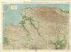
North Devon, Sheet 35 - Bartholomew's "Half Inch to the Mile Maps" of England & Wales
1 : 126720 Topographic maps Bartholomew, John George John Bartholomew & Co
Sheets 11-12. (Cary's England, Wales, and Scotland).
1 : 360000 Cary, John, ca. 1754-1835
Carte Particulière D'Une Partie D'Angleterre. Sur la Copie de Bruxelles Chez Eugène Henry Friex
1 : 116600 Mollova mapová sbírka Fricx, Eugène Henry Deur, Abraham Janszoon Covens, Johannes I
Partie de l'Angleterre
1 : 116600 Mollova mapová sbírka Fricx, Eugène Henry Harrewyn, Jacques Fricx, Eugené Henry
Devonshire
1 : 640000 Devon (Anglie) Hall, Sid. by Chapman & Hall
Devoniae descriptio = The description of Devon-Shire
1 : 180000 Amstelodami : apud Joannem Janssonium
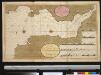
DEVONIAE COMOTAT
This map of Devon is by Christopher Saxton and dates from 1575. It forms part of an atlas that belonged to William Cecil Lord Burghley, Secretary of State to Elizabeth I. Burghley used this atlas to illustrate domestic matters. This map is actually a proof copy of one which forms part of Christopher Saxton’s Atlas of England and Wales. This atlas was first published as a whole in 1579. It consists of 35 coloured maps depicting the counties of England and Wales. The atlas is of great significance to British cartography as it set a standard of cartographic representation in Britain and the maps remained the basis for English county mapping, with few exceptions, until after 1750. During the reign of Elizabeth I map use became more common, with many government matters referring to increasingly accurate maps with consistent scales and symbols, made possible by advances in surveying techniques. This map was produced under the patronage of Thomas Seckford, a Master of Requests to Elizabeth I, who had commissioned Saxton’s atlas of county maps, a project overseen by Lord Burghley, Secretary of State, whose administration increasingly involved the use of maps. This map is interesting as there are several notes in the margins. In the lower right hand margin: 'A Note of hir maties Store of Ordonnaunce, powder and match, lead,&c.,remayningin ye L. Lieutenauntes, &c. hands'. In the upper right hand margin 'A Note what powder and match was appointed to be kept in store in every corporate towne'. In the left hand margin 'A Breef Note of ye places of Descent. . . yt are most daungerous and require greatest regard and assistaunce'. These annotations were most probably made by an assistant of Lord Burghley’s, and show the concern felt about coastal areas in the face of the threat from Spain which culminated in 1588 with the events of the Spanish Armada. Saxton, Christopher Hogenbergius, Remigius
A new map of the County of Devon
London : C. Smith