Maps of Northumberland

Northumberland nLX.NW - OS Six-Inch Map
1 : 10560 Topographic maps Ordnance Survey Ordnance Survey
Northumberland (Old Series) LV.13 (includes: Causey Park; Earsdon; Fenrother; Tritlington) - 25 Inch Map
1 : 2500 Topographic maps Ordnance Survey Ordnance Survey
Northumberland (New Series) LX.5 (includes: Bigges Quarter; Earsdon; Fenrother; High And Low Highlaws; Long Horsley Common; Tritlington) - 25 Inch Map
1 : 2500 Topographic maps Ordnance Survey Ordnance Survey
Northumberland (New Series) LX.1 (includes: Bigges Quarter; Causey Park; Earsdon; Long Horsley Common; Riddells Quarter) - 25 Inch Map
1 : 2500 Topographic maps Ordnance Survey Ordnance Survey
Northumberland (New Series) LX.6 (includes: Cockle Park; Earsdon; Tritlington; Ulgham) - 25 Inch Map
1 : 2500 Topographic maps Ordnance Survey Ordnance Survey
Northumberland (New Series) LX.2 (includes: Causey Park; Earsdon Forest; Earsdon; Tritlington) - 25 Inch Map
1 : 2500 Topographic maps Ordnance Survey Ordnance Survey
Northumberland (Old Series) LIV.16 (includes: Bigges Quarter; Causey Park; Earsdon; Fenrother; Long Horsley Common; Riddells Quarter) - 25 Inch Map
1 : 2500 Topographic maps Ordnance Survey Ordnance Survey
Northumberland (Old Series) LV.9 (includes: Causey Park; Earsdon Forest; Earsdon) - 25 Inch Map
1 : 2500 Topographic maps Ordnance Survey Ordnance Survey
Northumberland LV.SW - OS Six-Inch Map
1 : 10560 Topographic maps Ordnance Survey Ordnance Survey
Northumberland LIV.SE - OS Six-Inch Map
1 : 10560 Topographic maps Ordnance Survey Ordnance Survey
Northumberland (Old Series) LIV.12 (includes: Bigges Quarter; Causey Park; Riddells Quarter) - 25 Inch Map
1 : 2500 Topographic maps Ordnance Survey Ordnance Survey
Northumberland (Old Series) LXIV.1 (includes: Cockle Park; Fenrother; High And Low Highlaws; Tritlington) - 25 Inch Map
1 : 2500 Topographic maps Ordnance Survey Ordnance Survey
Northumberland (Old Series) LXIII.4 (includes: Fenrother; High And Low Highlaws; Stanton) - 25 Inch Map
1 : 2500 Topographic maps Ordnance Survey Ordnance Survey
Northumberland nLX - OS Six-Inch Map
1 : 10560 Topographic maps Ordnance Survey Ordnance Survey
NZ19 - OS 1:25,000 Provisional Series Map
1 : 25000 Topographic maps Ordnance Survey Ordnance Survey
Northumberland LV - OS Six-Inch Map
1 : 10560 Topographic maps Ordnance Survey Ordnance Survey
Northumberland LIV - OS Six-Inch Map
1 : 10560 Topographic maps Ordnance Survey Ordnance Survey
Northumberland LXIV.NW - OS Six-Inch Map
1 : 10560 Topographic maps Ordnance Survey Ordnance Survey
Northumberland LXIII.NE - OS Six-Inch Map
1 : 10560 Topographic maps Ordnance Survey Ordnance Survey
Northumberland (Old Series) LV.14 (includes: Earsdon; Tritlington; Ulgham) - 25 Inch Map
1 : 2500 Topographic maps Ordnance Survey Ordnance Survey
Northumberland (Old Series) LV.10 (includes: Earsdon Forest; Earsdon; Ulgham; Widdrington) - 25 Inch Map
1 : 2500 Topographic maps Ordnance Survey Ordnance Survey
Rothbury (Hills) - OS One-Inch Revised New Series
1 : 63360 Topographic maps Ordnance Survey Ordnance Survey
Rothbury (Outline) - OS One-Inch Revised New Series
1 : 63360 Topographic maps Ordnance Survey Ordnance Survey
Newcastle Upon Tyne - OS One-Inch Map
1 : 63360 Topographic maps Ordnance Survey Ordnance Survey
Alnwick - OS One-Inch Map
1 : 63360 Topographic maps Ordnance Survey Ordnance Survey
Northumberland, South, Sheet 2 - Bartholomew's "Half Inch to the Mile Maps" of England & Wales
1 : 126720 Topographic maps Bartholomew, John George John Bartholomew & Co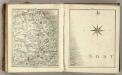
Sheets 68-69. (Cary's England, Wales, and Scotland).
1 : 360000 Cary, John, ca. 1754-1835
A new improved map of Northumberland
1 Karte : Kupferdruck ; 67 x 50 cm Kitchin; Hinton sold by J. Hinton at the Kings Arms in St. Pauls Church Yard
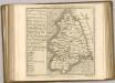
Comitatvs Northvmbria; vernacula Northvmberland
1 Karte : Kupferdruck ; 39 x 48 cm Blaeu Joan Blaeu