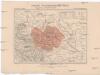
Maps of Kamienna Góra

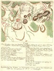
Plan Des Herrlichen Sieges bey Landshut in Schlesien
Mollova mapová sbírka
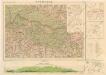
Meßtischblatt 5262 : Landeshut, 1939
1 : 250000 Landeshut. - Aufn. 1884, hrsg. 1886, bericht. 1936/37. - 1:25000. - [Berlin]: Reichsamt für Landesaufnahme, 1939. - 1 Kt.
Meßtischblatt 3072 : Landeshut, 1930
1 : 250000 Landeshut. - Hrsg. 1886, bericht. 1925, einz. Nachtr. 1930. - 1:25000. - [Berlin]: Reichsamt für Landesaufnahme, 1930. - 1 Kt.
Entwurff der bey Landshut in Schlesien den 13.ten u. 14.ten Augusti Ao 1757 vorgefallen Action unter Com[m]ando des Herrn Obristen Baron von Jahnus
Slezsko (Polsko) Salzer, Ignác
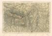
Krkonoše

Östliche Riesengebirge und die Adersbach-Wekelsdorfer Felsen
1 : 100000 Adršpašsko-teplické skály (Česko) G. Freytag & Berndt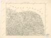
Podrobná místopisná mapa Království Českého

Specialkarte des Riesengebirges
1 : 75000 Krkonoše (Česko a Polsko : pohoří : oblast) Section Riesengebirge des Gebirgvereines für Böhmen
Krkonoše

Karte der Bezirkshauptmannschaft Trautenau
1 : 100000 Trutnov-oblast (Česko) Erben, Josef Karl Janský
Trautenau und Politz.
from Spezialkarte der osterreichisch-ungarischen Monarchie.
Generalkarte der Bezirkshauptmannschaft Trautenau
1 : 220000 Trutnov-oblast (Česko) Wagner, Jan Eduard F. Kytka
Generální mapa okresních hejtmanství

Straube ́s Wagekarte vom Riesen- und Iser- Gebirge

Krkonoše
Generalkarte der Bezirkshauptmannschaft Braunau
1 : 220000 Broumov-oblast (Náchod, Česko) Wagner, Jan Eduard F. Kytka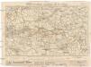
Straube's Wegkarte vom Riesen- und Iser-Gebirge
1 : 150000 Jizerské hory (Česko a Polsko) Straube, Julius Geogr. Institut u. Landkatern-Verlag Jul. Straube
Rübezahl Wegekarte vom Riesen und Isergebirge
Riesengebirge

Straube's Wegekarte vom Riesen- und Iser-Gebirge
1 : 150000 Krkonoše (Česko a Polsko) Straube, Julius Geograph. Inst. u. Landkarten-Verlag v. Jul. Staube
Podrobná mapa Krkonoš
1 : 100000 Krkonoše (Česko a Polsko : pohoří : oblast) Řehák, Adolf nákladem Severočeské knihtiskárny Edvarda Fastra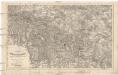
Charte des Riesengebirges
1 : 151000 Krkonoše (Česko a Polsko) Flemming, C. von C. Flemming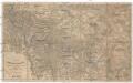
Charte des Riesengebirges
1 : 150000 Krkonoše (Česko a Polsko) Flemming, C. C. Flemming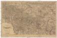
Charte des Riesengebirges
1 : 150000 Krkonoše (Česko a Polsko) Flemming, C. C. Flemming
Das Riesengebirge

Sec. Waldenburg
1 : 100000 Königliches Lithographisches Institut (Berlin) Simon Schroppsche Landkartenhndl.
Das Fürstenthum Schweidnitz in Nieder-Schlesien
1 : 290000 Svídnice-oblast (Polsko) Wieland, Johann Wolfgang Schleuen, Johann David I.D. Schleuen
Das Fürstenthum Schweidnitz in Nieder Schlesien
1 : 300000 Mollova mapová sbírka Schleuen, Johann David Schleuen, Johann David