Maps of Regierungsbezirk Stuttgart
Tabula nova Circuli Franconici
1 : 400000 Mollova mapová sbírka Jung, Johann Georg
Charte vom Fränkischen Kreise
1 Karte : Kupferdruck ; 44 x 53 cm Güssefeld im Verlage des Industrie-Comptoirs
Tabula Nova Circuli Franconici, cum omnibus suis limitibus ab Anno XXXVIII. hujusd. Seculi constructa, III. post Annis evulgata /
1 : 260000 Mollova mapová sbírka Endter, Wolfgang Moritz Eimmart, Georg Christoph Endter, Wolfgang Moritz
Franconia, Neue verbesserte Carten des Gantzen Fränkischen Kraÿses
1 : 740000 Mollova mapová sbírka Merian, Matthaeus Sandrart, Jakob von Sandrart, Jacob von
Franconia, Newe Carten Des Gantzen Fränckischen Krayses
1 : 740000 Mollova mapová sbírka Merian, Matthaeus Merian, Matthäus
Franconiae Nova Descriptio.
1 : 620000 Mollova mapová sbírka Rittershausen, Nicolaus
Grundrichtiger Entwurff des gantzen Franckenlandes
1 : 620000 Mollova mapová sbírka Rittershausen, Nicolaus Hipschmann, Sigmund Gabriel Hoffmann, Johann
Pagus Rangowe
1 Karte : Kupferdruck ; 46 x 55 cm Enderes; Strebel; Schneider zu finden in der Enderesischen Buchhandlung
Der Fraenkische Kreis nebst den angraenzenden Laendern
1 : 350000 Franky (Německo) Hammer, C. F. Lochner, Carl Frid. im Verlag der kaiserlich privilegirten Hommanischen Handlung
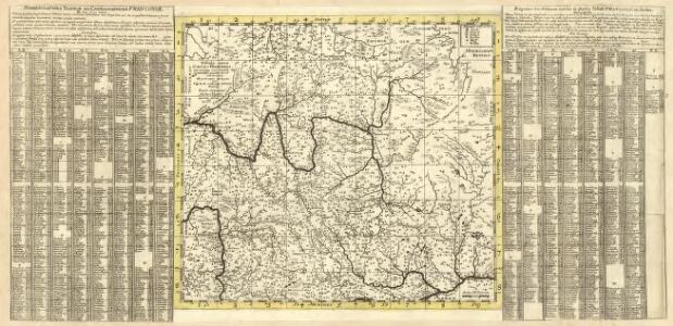
Serenissimo principi ac domino, domino Alexandro Ferdinando S. R. I. principi de Tour [et] Taxis
1 Karte auf 4 Blatt : Kupferdruck ; Gesamtgrösse 69 x 76 cm Homännische Erben
Teutschlandes Fraenckischer Creis samt dazu gehörigen Provintzen
1 : 1800000 Mollova mapová sbírka Weigel, Christoph Weigel, Christoph I.
Circuli Franconiae pars occidentalis, exhibiens simul integrum fere electoratum Moguntinum
1 : 427000 Ansbach (Německo) Homann, Johann Baptist Schönborn, Lothar Franz von Io. Bapt. Homann
Cercle de Franconie
1 Karte : Kupferdruck ; 47 x 55 cm Robert de Vaugondy; Haussard G. et D. Robert de Vaugondy
Charte von dem Fränkischen Kreise
1 : 569000 Franky (Německo) Kreibich, František Jakub Jindřich im Verlage des L. Ind. Compt.
Charte vom Fränkischen Kreise
1 : 538200 Franky (Německo) Güssefeld, Franz L. im Verlage des Industrie-Comptoirs

Franconiae Nova Descriptio. [Karte], in: Novus atlas absolutissimus, Bd. 2, S. 174.
1 Karte aus Atlas Janssonius Offizin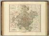
Franconia.
1 : 585000 Cary, John, ca. 1754-1835
Der Fraenkische Kreis
1 : 530000 Franky (Německo) Güssefeld, Franz L. bey denen Homaennischen Erben
Der Fraenkische Kreis
1 : 530000 Franky (Německo) Güssefeld, Franz L. Schmidt, I. M. bey denen Homaennischen Erben
Der Fraenkische Kreis
1 : 530000 Franky (Německo) Güssefeld, Franz L. Schmidt, I. M. Homaennischen Erben
Der Fraenkische Kreis
1 : 530000 Franky (Německo) Güssefeld, Franz L. Schmidt, I. M. bey denen Homaennischen Erben
Franconie.
1 : 485000 Robert de Vaugondy, Gilles, 1688-1766
Charte von dem Fränkischen Kreise
1 Karte : Kupferdruck ; 43 x 51 cm Kreibich im Verlage des Landes-Industrie-Comptoirs
Franconia vulgo Franckenlandt
1 Karte : Kupferdruck ; 37 x 48 cm Blaeu excudit Guiljelmus Blaeu
Franconia Vulgo Franckenlandt. [Karte], in: Le théâtre du monde, ou, Nouvel atlas contenant les chartes et descriptions de tous les païs de la terre, Bd. 1, S. 178.
1 Karte aus Atlas Blaeu, Willem Janszoon und Blaeu, Joan Blaeu, Willem Janszoon
Franconia Vulgo Franckenlandt. [Karte], in: Novus Atlas, das ist, Weltbeschreibung, Bd. 1, S. 147.
1 Karte aus Atlas Blaeu, Joan Blaeu, Willem Janszoon
Der Fraenkische Kreis
1 Karte : Kupferdruck ; 44 x 54 cm Güssefeld; Schmidt bey denen Homaennischen Erben
Le Cercle de Franconie
1 : 600000 Mollova mapová sbírka Jaillot, Alexis-Hubert Ottens, Josua