Maps of Reutlingen
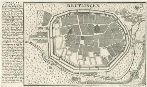
Reutlingen.
1 : 4000 Mollova mapová sbírka Bodenehr, Gabriel Bodenehr, Gabriel
Meßtischblatt 7521 : Reutlingen, 1936
1 : 250000 Reutlingen. - Aufn. 1871/1903, hrsg. 1908, bericht. 1936. - 1:25000. - Stuttgart, 1936. - 1 Kt.
Meßtischblatt [7521] : Reutlingen, 1915
1 : 250000 Reutlingen. - Hrsg. 1908, 2. Ausg. 1915. - 1:25000. - Stuttgart, 1915. - 1 Kt.
Meßtischblatt [7521] : Reutlingen, 1910
1 : 250000 Reutlingen. - 1:25000. - Stuttgart, 1910. - 1 Kt.
Meßtischblatt [7521] : Reutlingen, 1908
1 : 250000 Reutlingen. - 1:25000. - Stuttgart, 1908. - 1 Kt.
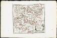
Geographica Provinciarum Sveviae Descriptio =
Mollova mapová sbírka Hurter, Johann Christoph Bodenehr, Johann Georg
Geographica Provinciarum Sveviae Descriptio =
Mollova mapová sbírka Hurter, Johann Christoph Bodenehr, Johann Georg
170. Stuttgart, uit: Topographische Uebersichtskarte des Deutschen Reiches / herausgegeben v. d. Kartogr. Abt. d. Königl. Preuß. Landesaufnahme
1 : 200000 titelvariant: Topogr. Übersichtskarte des Deutschen Reiches; Annotatie: Titel boven bladen ook: Topogr. Übersichtskarte des Deutschen Reiches; Annotatie geografische gegevens: Op elk blad twee maatstokken: 10 Kilometer = 5,5 cm; 1 geogr. Meile = 3,6 cm; Legenda onder op elk blad Königlich Preußische Landesaufnahme. Kartographische Abtheilung [S.l : Königlich Preußische Landesaufnahme, Kartographische Abtheilung]
Nordwestlicher Abhang der Schwäbischen Alp
Geologischer Atlas zur Naturgeschichte der Erde Leonhard, Carl Cäsar von E. Schweizerbart'sche Verlagsbuchhandlung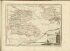
Des Herzogthums Würtemberg westsüdliche Aemter mit der freyen Reichsstadt Reutlingen : Nro. 188
Reilly, Franz Johann Joseph von
Tubingen
1 : 200000 Herder, Benjamin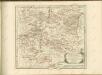

Stuttgart 128, uit: Special-Karte von Mittel-Europa / nach amtlichen Quellen bearbeitet von W. Liebenow
1 : 300000 titelvariant: W. Liebenow's Mittel-Europa; Annotatie: Titel boven de bladen: W. Liebenow's Mittel-Europa Johannes Wilhelm Liebenow 1822-1897 Frankfurt a. M. : Ludwig Ravenstein
Des Herzogthums Würtemberg westsüdliche Aemter mit der freyen Reichsstadt Reutlingen
1 Karte : Kupferdruck ; 23 x 26 cm Reilly F. J. J. von Reilly
Stuttgart 128, uit: [W. Liebenow's Special-Karte von Mittel-Europa]
1 : 300000 titelvariant: W. Liebenow's Mittel-Europa; Annotatie: Titel boven de bladen: W. Liebenow's Mittel-Europa Johannes Wilhelm Liebenow 1822-1897 Hannover : Hermann Oppermann
Suevia universa IX. tabulis delineata, 5
1 Blatt : s.n.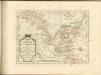

Carte topographique d'Allemagne
1 : 218000 Alsasko (Francie) Jaeger, Johann Wilhelm Abraham Facius, Johann Gottlieb chez I.W.A. Iaeger
Carte topographique d'Allemagne
1 : 218000 Alsasko (Francie) Jaeger, Johann Wilhelm Abraham I. W. A. Iaeger
Per Inclyti Circuli Suevici Supremorum Ordinum :
1 : 160000 Mollova mapová sbírka Pfeffel, Johann Andreas Pfeffel, Johann Andreas I.
Nova et accuratißima Ducatus Wurtenbergici
1 : 300000 Mollova mapová sbírka Seutter, Matthäus Seutter, Matthäus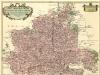
Carte tres Particuliere du Duché de Wirtemberg
1 : 240000 Mollova mapová sbírka Fer, Nicolas de Loon, Herman van L'Isle, Guillaume de
Per Inclyti Circuli Suevici Supremorum Ordinum
1 : 160000 Mollova mapová sbírka Pfeffel, Johann Andreas Homann, Johann Baptista - dědici
Generalkarte von Württemberg: Blatt III
1 : 1500000 Terrainzeichnung: Bach, Topograf und Hauptmann Lithografie: Rebmann und Sommer Herausgeber: K. statistisch-topografisches Büro
Generalkarte von Württemberg: Blatt I
1 : 1500000 Mit Übersichtskarte. Terrainzeichnung: Bach, Topograf und Hauptmann Lithografie: Rebmann und Sommer Herausgeber: K. statistisch-topografisches Büro
Generalkarte von Württemberg: Blatt IV
1 : 1500000 Terrainzeichnung: Bach, Topograf und Hauptmann Lithografie: Rebmann und Sommer Herausgeber: K. statistisch-topografisches Büro
Geographica provinciarum Sueviae descriptio, 3
4 Blätter : Johann Georg Bodenehr
Militair Karte von Süd-Deutschland in 20 Sectionen
1 : 400000 10. Section Coulon, Alois von A. von Coulon