Maps of Saxony

Des Ober Saechsischen Creises Südlicher theil mit abgetheilten Provintzen
1 : 2100000 Mollova mapová sbírka Weigel, Christoph Weigel, Christoph I.
Saxoniae Superioris, Praesertim Electoralis Circulus
1 : 500000 Mollova mapová sbírka Lotter, Tobias Conrad Lotter, Tobias Conrad
La Saxe Contenant les Routtes et les Postes
1 : 490000 Mollova mapová sbírka Le Rouge, Georges-Louis Le Rouge, Georges-Louis
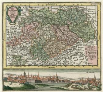
Saxoniæ superioris circulus
1 Karte : Kupferdruck ; 48 x 56 cm Seutter Matthäus Seutter
Saxonia Svperior
1 : 900000 Mollova mapová sbírka Weigel, Christoph Weigel, Christoph I.
Circvlvs Saxoniae Svperioris Quo ad partem meridionalem, exhibens Saxoniam Misniam et Thuringiam
1 : 2100000 Mollova mapová sbírka Franz, Johann Michael Homann, Johann Baptista - dědici
Circulus Saxoniae Superioris
1 : 590000 Mollova mapová sbírka Homann, Johann Baptist Homann, Johann Baptista
Saxoniae superioris
1 : 500000 Sasko (Německo) Lotter, Tobias Conrad T.C. Lotter
Saxoniae superioris
1 : 500000 Sasko (Německo) Lotter, Tobias Conrad T. C. Lotter
[Sasko]
Sasko (Německo) Jacob, Johann Gotthelff
Ducatus Saxoniae Superioris :
1 : 560000 Mollova mapová sbírka Zollmann, Friedrich Homann, Johann Baptista - dědici
Saxoniae Superioris praesertim electoralis circulus, cum adjacentibus ducatibus et provinciis simulque diligentissime annotatis postarum cursus et stationes mappa geographica
1 : 500000 recens et accurata delineata per Tob. Conradum Lotter Aug. Vindel. : per Tob. Conradum Lotter
Neue Reise Charte durch Sachsen zu beqvemen Gebrauch
1 : 1500000 Mollova mapová sbírka Schreiber, Johann Georg Schreiber, Johann Georg
Operations-Karte zum Feldzuge des Jahres 1761 in Sachsen
1 : 600000
Circuli Saxoniae Superior Pars Meridionalis
1 : 600000 Mollova mapová sbírka Wit, Frederik de Ottens, Josua
Circuli Saxoniae Superioris Pars Meridionalis
1 : 600000 Mollova mapová sbírka Wit, Frederik de
1:500,000 Europe (Air) G.S.G.S. No. 4072, Leipzig
Sheet NE50-10 from the map series: 1:500,000 Europe (Air) G.S.G.S. No. 4072.
Dvcatvs Electoratus et Principatus Dvcvm Saxoniae pro ut illorum conditio hodierna est Geographice consignati.
1 : 680000 Mollova mapová sbírka Homann, Johann Baptist Homann, Johann Baptista - dědici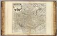
Haute Saxe meridionale.
1 : 600000 Robert de Vaugondy, Gilles, 1688-1766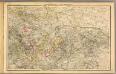
Thuringen u. Sachsen.
1 : 600000 Gutbier, Ludwig von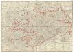
Post-Charte des Königreich Sachsen und der angränzenden Ländern
1 : 430000 Sasko (Německo) Güssefeld, Franz L. Geographisches Institut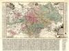
Aller Neueste Chur Saechsische Post Charte
1 : 340000 Mollova mapová sbírka Zürner, Adam Friedrich Lotter, Tobias Conrad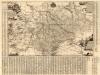
Neue Chur Saechsische Post Carte
1 : 330000 Mollova mapová sbírka Zürner, Adam Friedrich Bodenehr, Moritz
Charte der Koeniglich-Sächsischen und Herzoglich Sächsischen Lande
1 : 398000 Sasko (Německo)
Charte der Koeniglich-Sächsischen und Herzoglich Sächsischen Lande
1 : 398000 Sasko (Německo)
Operationen der Preussischen Haupt-Armee, der Armee des Feldmarschalls Daun und der Reichs-Armee vom 4ten bis 23ten November 1759

Sachsen, Thüringen und Benachbarte Laender
Stieler's Hand-Atlas Stieler, Adolf bei Justus Perthes
Sachsen, Thuringen und benachbarte Lander.
1 : 925000 Vogel, C.
CIRCULI SAXONIAE SUPERIORI[S]
1 : 620000 Anhaltsko (Německo) Wit, Frederick de F. de Wit