Maps of Saxony

La Saxe Contenant les Routtes et les Postes
1 : 490000 Mollova mapová sbírka Le Rouge, Georges-Louis Le Rouge, Georges-Louis
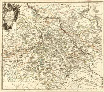
Saxoniae Superioris, Praesertim Electoralis Circulus
1 : 500000 Mollova mapová sbírka Lotter, Tobias Conrad Lotter, Tobias Conrad
Saxoniæ superioris circulus
1 Karte : Kupferdruck ; 48 x 56 cm Seutter Matthäus Seutter
Des Ober Saechsischen Creises Südlicher theil mit abgetheilten Provintzen
1 : 2100000 Mollova mapová sbírka Weigel, Christoph Weigel, Christoph I.
Saxonia Svperior
1 : 900000 Mollova mapová sbírka Weigel, Christoph Weigel, Christoph I.
Circvlvs Saxoniae Svperioris Quo ad partem meridionalem, exhibens Saxoniam Misniam et Thuringiam
1 : 2100000 Mollova mapová sbírka Franz, Johann Michael Homann, Johann Baptista - dědici
[Sasko]
Sasko (Německo) Jacob, Johann Gotthelff
Saxoniae Superioris praesertim electoralis circulus, cum adjacentibus ducatibus et provinciis simulque diligentissime annotatis postarum cursus et stationes mappa geographica
1 : 500000 recens et accurata delineata per Tob. Conradum Lotter Aug. Vindel. : per Tob. Conradum Lotter
Saxoniae superioris
1 : 500000 Sasko (Německo) Lotter, Tobias Conrad T.C. Lotter
Saxoniae superioris
1 : 500000 Sasko (Německo) Lotter, Tobias Conrad T. C. Lotter
Ducatus Saxoniae Superioris :
1 : 560000 Mollova mapová sbírka Zollmann, Friedrich Homann, Johann Baptista - dědici
Circuli Saxoniae Superior Pars Meridionalis
1 : 600000 Mollova mapová sbírka Wit, Frederik de Ottens, Josua
Circuli Saxoniae Superioris Pars Meridionalis
1 : 600000 Mollova mapová sbírka Wit, Frederik de
1:500,000 Europe (Air) G.S.G.S. No. 4072, Leipzig
Sheet NE50-10 from the map series: 1:500,000 Europe (Air) G.S.G.S. No. 4072.
Haute Saxe meridionale.
1 : 600000 Robert de Vaugondy, Gilles, 1688-1766
Thuringen u. Sachsen.
1 : 600000 Gutbier, Ludwig von
Post-Charte des Königreich Sachsen und der angränzenden Ländern
1 : 430000 Sasko (Německo) Güssefeld, Franz L. Geographisches Institut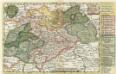
Neue Reise Charte durch Sachsen zu beqvemen Gebrauch
1 : 1500000 Mollova mapová sbírka Schreiber, Johann Georg Schreiber, Johann Georg
CIRCULI SAXONIAE SUPERIORI[S]
1 : 620000 Anhaltsko (Německo) Wit, Frederick de F. de Wit
Circuli Saxoniae superiori[s] pars meridionalis
1 : 620000 Anhaltsko (Německo) Danckerts, Justus per Iustinum Danckerts
Charte der Koeniglich-Sächsischen und Herzoglich Sächsischen Lande
1 : 398000 Sasko (Německo)
Charte der Koeniglich-Sächsischen und Herzoglich Sächsischen Lande
1 : 398000 Sasko (Německo)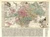
Aller Neueste Chur Saechsische Post Charte
1 : 340000 Mollova mapová sbírka Zürner, Adam Friedrich Lotter, Tobias Conrad
Circuli Saxoniae superiori[s] pars meridionalis
1 : 600000 1 Karte : Kupferdruck ; 47 x 55 cm Danckerts, Justus [Danckerts]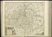
[42][42]Circuli Saxoniae Superioris pars meridionalis ..., uit: Atlas sive Descriptio terrarum orbis
Annotatie: Gedigitaliseerde versie. Amsterdam. Heiloo : Picturae (vervaardiger), 2015. tiff-bestand. Gedigitaliseerd: 07-01-2015; Origineel: Universiteitsbibliotheek Vrije Universiteit (XL.05127.-) ; Netherlands; Titelpagina ontbreekt Wit, Frederik de Amsterdam : Frederick de Wit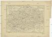
Charte des Königreichs Sachsen
1 : 965000 Sasko (Německo)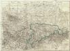
Oro- hydro-graphische general Charte vom Königreiche Sachsen und den angrenzenden Ländern
1 : 454000 Sasko (Německo) Bach, Joseph Rittnerschen Kunsthandlung
Mittel Deutschland
Neuer Handatlas über alle Theile der Erde Kiepert, Heinrich Verlag von Dietrich Reimer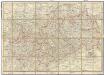
Post-Charte des Königreichs Sachsen und der angränzenden Länder
1 : 411000 Sasko (Německo) Güssefeld, Franz L. Keyl, C. im Geograph. Instituts