Maps of Heidenau

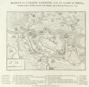
Blocus de L'Armée Saxonne dans son Camp de Pirna
1 : 65000 Mollova mapová sbírka Oebschelwitz, L. W. von Hondt, Pierre de
Plan von dem sächsischen und preußischen Lager bey Pirna 1756
Pirna (Německo) Trattner, Johann Thomas bey Johann Thomas Trattnern
Blocus de l'armée saxone dans son camp de Pirna, continué jusqu'a reddition pendant sept semaines, par le roi de Prusse en 1756
1 : 165000 Pirna (Německo) Schley, Jacobus van der Hondt, Pierre de chez Pierre de Hondt
Darstellung der Gegend zwischen Hohnstein in Sachsen und Peterswalde in Böhmen
1 : 45500 Petrovice-oblast (Ústí nad Labem, Česko) Aster, H. Renner, F. Adler & Dietze
Lager der Sächsischen und Preussischen Arméen bey Pirna samt unliegender Gegend 1757
1 : 70000 Mollova mapová sbírka Fridrich, Jacob Andreas Fridrich, Jacob Andreas
Situation du Camp Saxon entre Pirna et Koenigstein bloque des Prussiens depuis le commencement du Sept. ius qu'au 13. d'Oct. 1756 del par in Officier Saxon
1 : 65000 Mollova mapová sbírka
Plan und Situation derer Chur Sächsischen Trouppen Wie solche Anno 1756. Zwischen Pirna und Königstein campiret haben
1 : 45000 Mollova mapová sbírka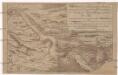
Retirade der sächsischen Armée aus ihrem Lager bei Königstein u. Pirna, und deren Übergang über die Elbe
Pirna (Německo)
Meßtischblatt 5049 : Pirna, 1941
1 : 250000 Pirna. - Aufn. 1930, letzte Nachtr. 1938, hrsg. 1935. - 1:25000. - Leipzig, 1941. - 1 Kt.
Meßtischblatt 83 : Pirna, 1925
1 : 250000 Pirna. - Umdr.-Ausg., aufgen. 1898, rev. 1905, hrsg. 1908. - 1:25000. - Leipzig, 1925. - 1 Kt.
Meßtischblatt 83 : Pirna, 1920
1 : 250000 Pirna. - Umdr.-Ausg., aufgen. 1898, rev. 1905, hrsg. 1908. - 1:25000. - Leipzig, 1920. - 1 Kt.
Meßtischblatt 83 : Pirna, 1912
1 : 250000 Pirna. - Aufgen. 1898, rev. 1905, hrsg. 1908, einz. Nachtr. 1912. - 1:25000. - Leipzig, 1912. - 1 Kt.
Meßtischblatt [5049] : Pirna, 1910
1 : 250000 Pirna. - Aufgen. 1898, rev. 1905, hrsg. 1908, einz. Nachtr. 1910. - 1:25000. - Leipzig, 1910. - 1 Kt.
Positiones der Kayserlich-Koeniglichen und Koeniglich-Preußischen Arméen, sowohl den 20. Novembr. 1759 bey der Action an dem Dorfe Maxen und Falkenhayn, als auch den 21. Novembr. bey Gefangennehmung der koenigl. Preuß. armée auf den Anhöhen vor Dohna
Maxen (Müglitztal, Německo)

Meßtischblatt 5050 : Königstein, 1944
1 : 250000 Königstein. - Aufn. 1931/32/33, letzte Nachtr. 1937, hrsg. 1937, Ausg. 1943. - 1:25000. - Leipzig, 1944. - 1 Kt.
Meßtischblatt 84 : Königstein, 1920
1 : 250000 Königstein. - Umdr.-Ausg., aufgen. 1898, rev. 1902, hrsg. 1908. - 1:25000. - Leipzig, 1920. - 1 Kt.
Meßtischblatt 84 : Königstein, 1914
1 : 250000 Königstein. - Aufgen. 1898, rev. 1902, hrsg. 1908, einz. Nachtr. 1914. - 1:25000. - Leipzig, 1914. - 1 Kt.
Meßtischblatt 84 : Königstein, 1912
1 : 250000 Königstein. - Aufgen. 1898, rev. 1902, hrsg. 1908, einz. Nachtr. 1912. - 1:25000. - Leipzig, 1912. - 1 Kt.
Meßtischblatt 84 : Königstein, 1909
1 : 250000 Königstein. - Aufgen. 1898, rev. 1902, hrsg. 1908, einz. Nachtr. 1909. - 1:25000. - Leipzig, 1909. - 1 Kt.
Plan de L'affaire de Maxen du 20me gbr. 1759
Hill, Johann Jakob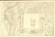
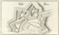
Schloß Pirna
1 : 1200 Mollova mapová sbírka Merian, Matthaeus Merian, Matthäus
Gegend bei Pirna

Die Sächsische Schweiz
1 : 144000 Saské Švýcarsko (Německo) Becker Hajeck Arnoldischen Buchhandlung
Sächsische Schweiz

Eisenbahn Karte Wien-Dresden, Ollmütz-Trübau
1 : 72000 Blatt 16 Minarzik, Anselm J. Rauh
Plan Von der Gegend Dresden bis Königstein, wie a[nn]o 1759 den 20. Novem. die Preussen aus ihrem verschantzten Lager bey Maxen vertrieben worden, sich von einer Anhöhe zur andern retirirt, und bey Ploschwitz das Gewehr gestreckt haben
Bettenhaeusser
Topographische Reisekarte durch die Meissnischen Aemter Hohenstein und Lohmen und einen Theil der Aemten Pirna und Stolpen oder die sogenannte Sächsische Schweiz
1 : 110000 Míšeň-oblast (Německo) Götzinger, Wilhelm Lebrecht Kreybich, Carl