Maps of Kreischa

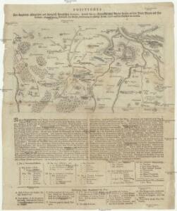
Positiones der Kayserlich-Koeniglichen und Koeniglich-Preußischen Arméen, sowohl den 20. Novembr. 1759 bey der Action an dem Dorfe Maxen und Falkenhayn, als auch den 21. Novembr. bey Gefangennehmung der koenigl. Preuß. armée auf den Anhöhen vor Dohna
Maxen (Müglitztal, Německo)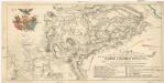
Plan du combat de Maxen
Maxen (Müglitztal, Německo) Trattner, Johann Thomas chez Jean Thomas Trattner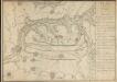
Plan de L'affaire de Maxen du 20me gbr. 1759
Hill, Johann Jakob
Meßtischblatt 82 : Kreischa, 1921
1 : 250000 Kreischa. - Umdr.-Ausg., aufgen. 1909, hrsg. 1912, bericht. 1921. - 1:25000. - Leipzig, 1921. - 1 Kt.
Meßtischblatt 82 : Kreischa, 1920
1 : 250000 Kreischa. - Aufgen. 1909, hrsg. 1912, einz. Nachtr. 1920. - 1:25000. - Leipzig, 1920. - 1 Kt.
Meßtischblatt 82 : Kreischa, 1916
1 : 250000 Kreischa. - Aufgen. 1909, hrsg. 1912, einz. Nachtr. 1916. - 1:25000. - Leipzig, 1916. - 1 Kt.
Meßtischblatt 82 : Kreischa, 1913
1 : 250000 Kreischa. - Aufgen. 1909, hrsg. 1912, einz. Nachtr. 1913. - 1:25000. - Leipzig, 1913. - 1 Kt.
Meßtischblatt 5049 : Pirna, 1941
1 : 250000 Pirna. - Aufn. 1930, letzte Nachtr. 1938, hrsg. 1935. - 1:25000. - Leipzig, 1941. - 1 Kt.
Meßtischblatt 83 : Pirna, 1925
1 : 250000 Pirna. - Umdr.-Ausg., aufgen. 1898, rev. 1905, hrsg. 1908. - 1:25000. - Leipzig, 1925. - 1 Kt.
Meßtischblatt 83 : Pirna, 1920
1 : 250000 Pirna. - Umdr.-Ausg., aufgen. 1898, rev. 1905, hrsg. 1908. - 1:25000. - Leipzig, 1920. - 1 Kt.
Meßtischblatt 83 : Pirna, 1912
1 : 250000 Pirna. - Aufgen. 1898, rev. 1905, hrsg. 1908, einz. Nachtr. 1912. - 1:25000. - Leipzig, 1912. - 1 Kt.
Meßtischblatt [5049] : Pirna, 1910
1 : 250000 Pirna. - Aufgen. 1898, rev. 1905, hrsg. 1908, einz. Nachtr. 1910. - 1:25000. - Leipzig, 1910. - 1 Kt.
Projects de quelques positions qu'on pourrait former dans les environs de Maxen
1 : 21000 Maxen (Müglitztal, Německo) Nestler, Carl Gottfried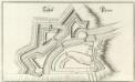
Schloß Pirna
1 : 1200 Mollova mapová sbírka Merian, Matthaeus Merian, Matthäus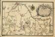
Plan Von der Gegend Dresden bis Königstein, wie a[nn]o 1759 den 20. Novem. die Preussen aus ihrem verschantzten Lager bey Maxen vertrieben worden, sich von einer Anhöhe zur andern retirirt, und bey Ploschwitz das Gewehr gestreckt haben
Bettenhaeusser
Blocus de L'Armée Saxonne dans son Camp de Pirna
1 : 65000 Mollova mapová sbírka Oebschelwitz, L. W. von Hondt, Pierre de
Blocus de l'armée saxone dans son camp de Pirna, continué jusqu'a reddition pendant sept semaines, par le roi de Prusse en 1756
1 : 165000 Pirna (Německo) Schley, Jacobus van der Hondt, Pierre de chez Pierre de Hondt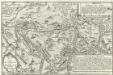
Lager der Sächsischen und Preussischen Arméen bey Pirna samt unliegender Gegend 1757
1 : 70000 Mollova mapová sbírka Fridrich, Jacob Andreas Fridrich, Jacob Andreas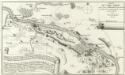
Situation du Camp Saxon entre Pirna et Koenigstein bloque des Prussiens depuis le commencement du Sept. ius qu'au 13. d'Oct. 1756 del par in Officier Saxon
1 : 65000 Mollova mapová sbírka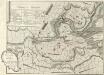
Plan und Situation derer Chur Sächsischen Trouppen Wie solche Anno 1756. Zwischen Pirna und Königstein campiret haben
1 : 45000 Mollova mapová sbírka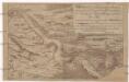
Retirade der sächsischen Armée aus ihrem Lager bei Königstein u. Pirna, und deren Übergang über die Elbe
Pirna (Německo)
Section Dresden
1 : 56000 Drážďany-oblast (Německo) Bach F.T. Hultzsch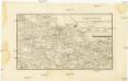
Position de toutes les armees et corps en Saxe le 19 et 20 Novbr [i.e. Novembre] 1759
1 : 165000 Drážďany-oblast (Německo) Werner, C. G.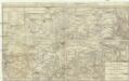
Topographische Reisekarte durch die umliegende Gegend von Dresden
1 : 200000 Drážďany-oblast (Německo) Lehmann, Johann Georg Arnoldischen Buch- und Kunsthandlung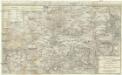
Topographische Reisekarte durch die umliegende Gegend von Dresden
1 : 200000 Drážďany-oblast (Německo) Lehmann, Johann Georg Keyl, Carl Arnoldischen Buch- und Kunsthandlung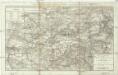
Topographische Reisekarte durch die umliegende Gegend von Dresden
1 : 200000 Drážďany-oblast (Německo) Lehmann, Johann Georg Keyl, Carl Arnoldischen Buch- und Kunsthandlung
Accurate Geographische Delineation Der Dioces Und Des Ammtes Dresden
1 : 120000 Mollova mapová sbírka Schenk, Pieter Zürner, Adam Friedrich
Accuratissima Delineatio Geographica Dioecesis Ac Praefecturae Dresdensis
1 : 120000 Mollova mapová sbírka Seutter, Matthäus Lotter, Tobias Conrad Seutter, Matthäus
Plan der Schlacht der Kulm den 30ten Aug. 1813
1 : 200000 Chlumec (Ústí nad Labem, Česko) Timlich