Maps of Sächsische Schweiz-Osterzgebirge
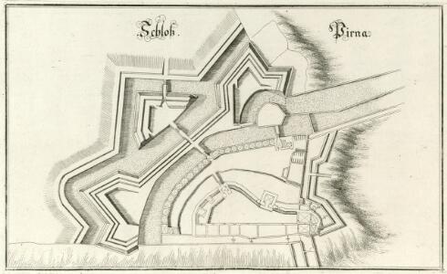
Schloß Pirna
1 : 1200 Mollova mapová sbírka Merian, Matthaeus Merian, Matthäus
Meßtischblatt 5049 : Pirna, 1941
1 : 250000 Pirna. - Aufn. 1930, letzte Nachtr. 1938, hrsg. 1935. - 1:25000. - Leipzig, 1941. - 1 Kt.
Meßtischblatt 83 : Pirna, 1925
1 : 250000 Pirna. - Umdr.-Ausg., aufgen. 1898, rev. 1905, hrsg. 1908. - 1:25000. - Leipzig, 1925. - 1 Kt.
Meßtischblatt 83 : Pirna, 1920
1 : 250000 Pirna. - Umdr.-Ausg., aufgen. 1898, rev. 1905, hrsg. 1908. - 1:25000. - Leipzig, 1920. - 1 Kt.
Meßtischblatt 83 : Pirna, 1912
1 : 250000 Pirna. - Aufgen. 1898, rev. 1905, hrsg. 1908, einz. Nachtr. 1912. - 1:25000. - Leipzig, 1912. - 1 Kt.
Meßtischblatt [5049] : Pirna, 1910
1 : 250000 Pirna. - Aufgen. 1898, rev. 1905, hrsg. 1908, einz. Nachtr. 1910. - 1:25000. - Leipzig, 1910. - 1 Kt.
Retirade der sächsischen Armée aus ihrem Lager bei Königstein u. Pirna, und deren Übergang über die Elbe
Pirna (Německo)
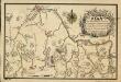
Lager der Sächsischen und Preussischen Arméen bey Pirna samt unliegender Gegend 1757
1 : 70000 Mollova mapová sbírka Fridrich, Jacob Andreas Fridrich, Jacob Andreas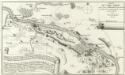
Situation du Camp Saxon entre Pirna et Koenigstein bloque des Prussiens depuis le commencement du Sept. ius qu'au 13. d'Oct. 1756 del par in Officier Saxon
1 : 65000 Mollova mapová sbírka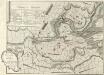
Plan und Situation derer Chur Sächsischen Trouppen Wie solche Anno 1756. Zwischen Pirna und Königstein campiret haben
1 : 45000 Mollova mapová sbírka
Positiones der Kayserlich-Koeniglichen und Koeniglich-Preußischen Arméen, sowohl den 20. Novembr. 1759 bey der Action an dem Dorfe Maxen und Falkenhayn, als auch den 21. Novembr. bey Gefangennehmung der koenigl. Preuß. armée auf den Anhöhen vor Dohna
Maxen (Müglitztal, Německo)
Blocus de l'armée saxone dans son camp de Pirna, continué jusqu'a reddition pendant sept semaines, par le roi de Prusse en 1756
1 : 165000 Pirna (Německo) Schley, Jacobus van der Hondt, Pierre de chez Pierre de Hondt
Blocus de L'Armée Saxonne dans son Camp de Pirna
1 : 65000 Mollova mapová sbírka Oebschelwitz, L. W. von Hondt, Pierre de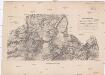
Darstellung der Gegend zwischen Hohnstein in Sachsen und Peterswalde in Böhmen
1 : 45500 Petrovice-oblast (Ústí nad Labem, Česko) Aster, H. Renner, F. Adler & Dietze
Die Sächsische Schweiz
1 : 153000 Saské Švýcarsko (Německo) Medau, Karel Vilém C.W. Medau
Wanderkarte Sächsische Schweiz

Plan von dem sächsischen und preußischen Lager bey Pirna 1756
Pirna (Německo) Trattner, Johann Thomas bey Johann Thomas Trattnern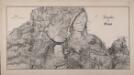
Gegend bei Pirna
Plan Von der Gegend Dresden bis Königstein, wie a[nn]o 1759 den 20. Novem. die Preussen aus ihrem verschantzten Lager bey Maxen vertrieben worden, sich von einer Anhöhe zur andern retirirt, und bey Ploschwitz das Gewehr gestreckt haben
Bettenhaeusser
Podmokly
1 : 75000 Německo Vojenský zeměpisný ústav
Podmokly
1 : 75000 Čechy (Česko) Vojenský zeměpisný ústav
III. vojenské mapování 3652
1 : 75000
Sächsisch-Böhmische Schweiz
1 : 50000 Saské Švýcarsko (Německo) C.C. Meinhold & Söhne
Die Sächsische Schweiz
Saské Švýcarsko (Německo) Lehmann, Johann Georg Becker Arnoldische Buchhandlung
Bodenbach und Tetschen
1 : 75000 Děčín (Česko : oblast) Brunner, J. K. u. k. militär-geographisches Institut
Bodenbach und Tetschen
1 : 75000 Děčín (Česko : oblast) Brunner, J. K. u. k. Militärgeographisches Institut
Bodenbach und Tetschen
1 : 75000 Děčín (Česko : oblast) K. u. k. Militärgeographisches Institut
Section Dresden
1 : 56000 Drážďany-oblast (Německo) Bach F.T. Hultzsch
Die Gegend der Haupt- und Residentz- Stadt dresden von drey Meil Weegs im Umcreyß
Mollova mapová sbírka Lidl, Johann Jakob Lidl, Johann Jacob