Maps of Kreis Viersen

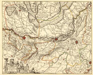
Tetrarchia Ducatus Geldriae Ruremondana Sive Hispanica
1 : 110000 Mollova mapová sbírka Wit, Frederik de Covens, Johannes I
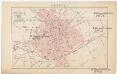
Bl. 34 Venlo, 1904, uit: Atlas A.N.W.B.
1 : 200000 titelvariant: Atlas van Nederland van den A.N.W.B. Toeristenbond voor Nederland; Wielrijders-atlas van Nederland; Annotatie: Titel op bladwijzer: Atlas van Nederland van den A.N.W.B. Toeristenbond voor Nederland; Titel op legendablad: Wielrijders-atlas van Nederland; Voor aanwezige bladen zie overzichtsblad; Annotatie geografische gegevens: De serie bestaat uit 36 bladen ANWB ['s-Gravenhage : A.N.W.B.]
FOSSA SANCTÆ MARIÆ | quæ EVGENIANA dicitur Vulgo De Nieuwe Grift.
Excudit Guilj. Janßonius Blaeuw
Bijlage 5, uit: Eindverslag over de onderzoekingen en uitkomsten van den Dienst der Rijksopsporing van Delfstoffen in Nederland, 1903-1916
Annotatie: Met lit. opg Departement van Landbouw, Nijverheid en Handel. Dienst der Rijksopsporing van Delfstoffen ['s-Gravenhage : Martinus Nijhoff]
Delineatio & descriptio novi canalis, qui non ita pridem derivari cepit circa Rhenum in Mosam, quod opus ceptum 21. die septembris, anni 1626 & perductu[m] Rheinbergâ Geldriam usq., quatuor miliaria in longitudine, in latitudine 50. pedes, altera pars Geldriâ usq. Venloum (quae distantia pariter est circiter 4. miliaru[m]) ultra dimidiam partem fodiendo peracta, & quotidie perficitur
Geldern (Německo)
Carte particuliere des environs de Venlo et de Roermonde
1 : 163000 Venlo (Nizozemsko) Covens & Mortier
Plan de la Bataille d'Anrad, dans la Plaine de Creeveld
1 : 40000 Mollova mapová sbírka
33 Venlo, uit: De Tranchotkaart van het gebied tussen Maas en Rijn : Nederlands gedeelte
Annotatie: Omslagtitel; Facs. van het Nederlandse deel van de manuscriptkaart van het Rijnland vervaardigd o.l.v. Jean Joseph Tranchot, 1803-1820. - Gereduceerd van 1:20.000 tot 1:25.000 Jean Joseph Tranchot 1752-1815 [Maastricht : Stichting Maaslandse Monografieën]
Bataille De Creveld Ou D'Anrad Entre les Francois et les Hanovriens le 23. Juin 1758
1 : 40000 Le Rouge, Georges-Louis chez le Rouge Ing.r Geogr.e du Roi rue des grands Augustins
Plan de la Bataille, gagnée par l'Armée des Alliés, aux Ordres de S. A. S. Mr. le Prince Ferdinand de Brunswic, sur celle de France, commandée par Mr. le Prince de Clermont, près d'Andrad, le 23 Juin 1758
1 : 70000 Mollova mapová sbírka Schley, Jacobus van der Hondt, Pierre de
Bataille de Creveld entre les alliés commandés par le Duc Ferdinand de Brunswic & les français aux ordres du Comte de Clermont le 23 Juin 1758
Therbu, Laurids de; Coentgen, Heinrich Hugo
Meßtischblatt 4705 : Willich, 1939
1 : 250000 Willich. - Aufn. 1892, hrsg. 1894, bericht. 1938. - 1:25000. - [Berlin]: Reichsamt für Landesaufnahme, 1939. - 1 Kt.
Meßtischblatt 2716 : Viersen, 1934
1 : 250000 Viersen. - Hrsg. 1894, bericht. 1926, gedr. [19]34. - 1:25000. - [Berlin]: Reichsamt für Landesaufnahme, 1934. - 1 Kt.
Meßtischblatt 2715 : Waldniel, 1917
1 : 250000 Waldniel. - Aufn. 1892, hrsg. 1894, Aufl.-dr. 1917. - 1:25000. - [Berlin]: Reichsamt für Landesaufnahme, 1917. - 1 Kt.
Meßtischblatt 2714 : Elmpt, 1893
1 : 250000 Elmpt. - Aufn. 1892. - 1:25000. - [Berlin]: Reichsamt für Landesaufnahme, 1893. - 1 Kt.
Meßtischblatt 2647 : Krefeld, 1927
1 : 250000 Krefeld. - Aufn. 1892, bericht. 1926, Nachtr. 1927. - 1:25000. - [Berlin]: Reichsamt für Landesaufnahme, 1927. - 1 Kt.
Meßtischblatt 2646 : Kempen, 1894
1 : 250000 Kempen. - Aufn. 1892. - 1:25000. - [Berlin]: Reichsamt für Landesaufnahme, 1894. - 1 Kt.
Meßtischblatt 4602 : Tegelen, 1953
1 : 250000 Tegelen. - Aufn. 1892, hrsg. 1894, bericht. 1939, letzte Nachtr. 1922/34, redakt. Änd. [19]53. - 1:25000. - [Berlin]: Reichsamt für Landesaufnahme, 1953. - 1 Kt.
Meßtischblatt 2644/2645, [neue Nr. 4602/4603] : Kaldenkirchen, 1936
1 : 250000 Kaldenkirchen. - Hrsg. 1894, bericht. 1926, einz. Nachtr. 1936. - 1:25000. - [Berlin]: Reichsamt für Landesaufnahme, 1936. - 1 Kt.
Messtischblatt 2573 : Mörs, 1926 Mörs
1 : 250000 Mörs. - Aufn. 1892, bericht. 1926. - 1:25000. - [Berlin]: Reichsamt für Landesaufnahme, 1926. - 1 Kt.
Messtischblatt 2572 : Nieukerk, 1910 Nieukerk
1 : 250000 Nieukerk. - Aufn. 1892, hrsg. 1894, bericht. 1907, einz. Nachtr. 1910. - 1:25000. - [Berlin]: Reichsamt für Landesaufnahme, 1910. - 1 Kt.
Messtischblatt 2572 : Nieukerk, 1894 Nieukerk
1 : 250000 Nieukerk. - Aufn. 1892. - 1:25000. - [Berlin]: Reichsamt für Landesaufnahme, 1894. - 1 Kt.
Messtischblatt 2571 : Straelen, 1893
1 : 250000 Straelen. - Aufn. 1892, hrsg. 1893, bericht. 1907. - 1:25000. - [Berlin]: Reichsamt für Landesaufnahme, 1907. - 1 Kt.
40 Brüggen, uit: De Tranchotkaart van het gebied tussen Maas en Rijn : Nederlands gedeelte
Annotatie: Omslagtitel; Facs. van het Nederlandse deel van de manuscriptkaart van het Rijnland vervaardigd o.l.v. Jean Joseph Tranchot, 1803-1820. - Gereduceerd van 1:20.000 tot 1:25.000 Jean Joseph Tranchot 1752-1815 [Maastricht : Stichting Maaslandse Monografieën]
Meßtischblatt 2778 : Wevelinghoven, 1896
1 : 250000 Wevelinghoven. - Aufn. 1893. - 1:25000. - [Berlin]: Reichsamt für Landesaufnahme, 1896. - 1 Kt.
Meßtischblatt 4804 : M. Gladbach, 1952
1 : 250000 M. Gladbach. - Aufn. 1893, hrsg. 1895, bericht. 1938, letzte Nahtr. 1944. - 1:25000. - [Bonn-Bad Godesberg]: LVA NW, 1952. - 1 Kt.
Meßtischblatt 2776 : Wegberg, 1895
1 : 250000 Wegberg. - Aufn. 1893. - 1:25000. - [Berlin]: Reichsamt für Landesaufnahme, 1895. - 1 Kt.
Meßtischblatt 2775 : Birgelen, 1894
1 : 250000 Birgelen. - Aufn. 1893. - 1:25000. - [Berlin]: Reichsamt für Landesaufnahme, 1894. - 1 Kt.
47 Herkenbosch, uit: De Tranchotkaart van het gebied tussen Maas en Rijn : Nederlands gedeelte
Annotatie: Omslagtitel; Facs. van het Nederlandse deel van de manuscriptkaart van het Rijnland vervaardigd o.l.v. Jean Joseph Tranchot, 1803-1820. - Gereduceerd van 1:20.000 tot 1:25.000 Jean Joseph Tranchot 1752-1815 [Maastricht : Stichting Maaslandse Monografieën]