Maps of Kerken

Maps of Kerken

$title$

Messtischblatt 2572 : Nieukerk, 1910 Nieukerk

1 : 250000 Nieukerk. - Aufn. 1892, hrsg. 1894, bericht. 1907, einz. Nachtr. 1910. - 1:25000. - [Berlin]: Reichsamt für Landesaufnahme, 1910. - 1 Kt.
$title$

Messtischblatt 2572 : Nieukerk, 1894 Nieukerk

1 : 250000 Nieukerk. - Aufn. 1892. - 1:25000. - [Berlin]: Reichsamt für Landesaufnahme, 1894. - 1 Kt.
$title$

WACHTENDONCK

[Amsterdam : Joan Blaeu]
$title$

Delineatio & descriptio novi canalis, qui non ita pridem derivari cepit circa Rhenum in Mosam, quod opus ceptum 21. die septembris, anni 1626 & perductu[m] Rheinbergâ Geldriam usq., quatuor miliaria in longitudine, in latitudine 50. pedes, altera pars Geldriâ usq. Venloum (quae distantia pariter est circiter 4. miliaru[m]) ultra dimidiam partem fodiendo peracta, & quotidie perficitur

Geldern (Německo)
$title$

Illustrissimo Celsissimoq; Principi Guilielmo Henrico D. G. Arausionum Principi Domino suo Clementissimo Hanc Comitatus Meursensis et Annexarum Dinastiarum Accuratam Tabulam humillime Offert

1 : 80000 Mollova mapová sbírka Heurdt, A. van Wit, Frederick
$title$

Fossa quae a Rheno ad Mosam duci caepta est Anno MDCXXVII

1 : 120000 Mollova mapová sbírka Blaeu, Willem Janszoon Blaeu, Joan I.
$title$

Bl. 34 Venlo, 1904, uit: Atlas A.N.W.B.

1 : 200000 titelvariant: Atlas van Nederland van den A.N.W.B. Toeristenbond voor Nederland; Wielrijders-atlas van Nederland; Annotatie: Titel op bladwijzer: Atlas van Nederland van den A.N.W.B. Toeristenbond voor Nederland; Titel op legendablad: Wielrijders-atlas van Nederland; Voor aanwezige bladen zie overzichtsblad; Annotatie geografische gegevens: De serie bestaat uit 36 bladen ANWB ['s-Gravenhage : A.N.W.B.]
$title$

Mürs Comitatus [Karte] Mürs Oppidum et Arx. [Nebenkarte] Modiliana. [Nebenkarte], in: Gerardi Mercatoris Atlas, sive, Cosmographicae meditationes de fabrica mundi et fabricati figura, S. 352.

1 Karte aus Atlas Mercator, Gerhard Montanus, Petrus
$title$

Mürs Comitatus [Karte] Mürs Oppidum et Arx [Nebenkarte] Modiliana. [Nebenkarte], in: Gerardi Mercatoris et I. Hondii Newer Atlas, oder, Grosses Weltbuch, Bd. 1, S. 211.

1 Karte aus Atlas Mercator, Gerhard und Hondius, Jodocus Jansson, Jan
$title$

Tetrarchia Ducatus Geldriae Ruremondana Sive Hispanica

1 : 110000 Mollova mapová sbírka Wit, Frederik de Covens, Johannes I
$title$

[62][62] Comitatus Meursensis ..., uit: Atlas sive Descriptio terrarum orbis

Annotatie: Gedigitaliseerde versie. Amsterdam. Heiloo : Picturae (vervaardiger), 2015. tiff-bestand. Gedigitaliseerd: 07-01-2015; Origineel: Universiteitsbibliotheek Vrije Universiteit (XL.05127.-) ; Netherlands; Titelpagina ontbreekt Wit, Frederik de Amsterdam : Frederick de Wit
$title$

FOSSA SANCTÆ MARIÆ | quæ EVGENIANA dicitur Vulgo De Nieuwe Grift.

Excudit Guilj. Janßonius Blaeuw
$title$

Geldern Eine Statt und Haupt Vestung im Hertzogthum gleiches Nahmens gelegen Mitt der Gegend auff 4 Stunden

1 : 340000 Mollova mapová sbírka Bodenehr, Gabriel Bodenehr, Gabriel
$title$

Fossa Eugeniana quae a Rheno ad Mosam duci coepta est, anno MDCXXII ductu comitis Henrici vanden Berge / [Joannes Janssonius]

1 : 80000 Annotatie: Het eerst verschenen in: Novus Atlas, das ist, Weltbeschreibung ... Zweite Theil. - Amsterdami : apud Iohannem Ianssonium, 1645; Origineel is Blad 66 in atlas factice; Annotatie geografische gegevens: Noordwest boven Janssonius, Joannes (jr.) (1588-1664) Amstelodami : sumptibus Ioannis Ianssonii
$title$

Fossa Eugeniana quae a Rheno ad Mosam duci coepta est, Anno CICICCXXVII ductu Comitis Henrici vanden Berge. [Karte], in: Novus atlas absolutissimus, Bd. 3, S. 103.

1 Karte aus Atlas Janssonius Offizin
$title$

Fossa Eugeniana quae a Rheno ad Mosam duci coepta est, Anno CICICCXXVII ductu Comitis [...] [Karte], in: Gerardi Mercatoris et I. Hondii Newer Atlas, oder, Grosses Weltbuch, Bd. 1, S. 413.

1 Karte aus Atlas Mercator, Gerhard und Hondius, Jodocus Jansson, Jan
$title$

Fossa quae a Rheno ad Mosam duci coepta est, anno MDCXXII.

1 : 143000 Amsterdam : excudit Guilj. Janssonius Blaeuw
$title$

Fossa Sanctae Mariae, quae et Eugeniana dicitur Vulgo De Nieuwe Grift. [Karte], in: Novus Atlas, das ist, Weltbeschreibung, Bd. 1, S. 385.

1 Karte aus Atlas Blaeu, Joan Blaeu, Willem Janszoon
$title$

Fossa Sanctae Mariae, quae et Eugeniana dicitur Vulgo De Nieuwe Grist. [Karte], in: Le théâtre du monde, ou, Nouvel atlas contenant les chartes et descriptions de tous les païs de la terre, Bd. 1, S. 414.

1 Karte aus Atlas Blaeu, Willem Janszoon und Blaeu, Joan Blaeu, Willem Janszoon
$title$

Fossa Sanctae Mariae, quae et Eugeniana dicitur Vulgo De Nieuwe Grist. [Karte], in: Theatrum orbis terrarum, sive, Atlas novus, Bd. 1, S. 413.

1 Karte aus Atlas Blaeu, Joan Blaeu, Willem Janszoon
$title$

V, uit: Carte chorographique des Pays-Bas Autrichiens / ... par le Comte de Ferraris ; gravée par L.A. Dupuis

1 : 86400 Annotatie: Lit.: Les militaires et la cartographie des Pays-Bas méridionaux et de la Principauté de Liège à la fin du XVIIe et au XVIII siècle / Claire Lemoine-Isabeau. - Bruxelles, 1984, p. 206-212; La cartographie au XVIIIe siècle et l'oeuvre du Comte de Ferraris (1726-1814) : colloque international, Spa, 8-11 sept. 1976. - Bruxelles, 1978; Met opdracht aan keizer Joseph II (bl.XVI); Met plattegrond van Brussel (bl. XXI), overzichtskaart (bl. XXII) en bladwijzer (bl. XXIII); Ontbreekt: bl. I-III en XXI; Voor aanwezige bladen zie overzichtsblad Ferraris, Johann Joseph; Dupuis, L. A. [S.l. : s.n.]
$title$

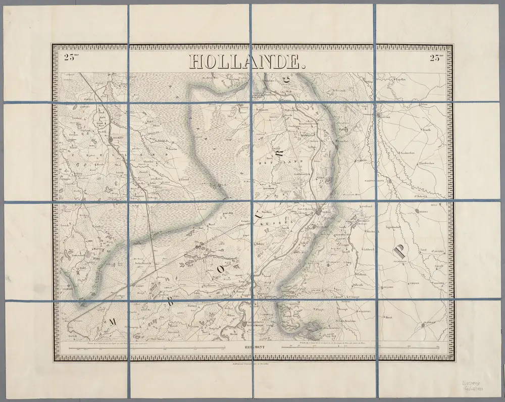
23me Helmont, uit: Nouvelle carte de la Hollande, d'après Kraijenhoff et les meilleures cartes connues / Établissement Géographique de Bruxelles, fondé par Ph. Vander Maelen

1 : 117000 Annotatie: De bladen zijn genummerd 1-24. De bladen 2 t/m 24 hebben elk een afzonderlijke titel. Blad 5 bevat: Triangulations et positions. Blad 9 bevat: Plan d'Amsterdam; De kaartbladen 1, 5, 9 en 24 zijn niet ingekleurd; Van kaartblad 24 is een extra (ingekleurd) exempl. aanwezig; Annotatie geografische gegevens: 2 schaalstokken: 5 Echelle de 5 lieues de 20 au degré ... (= 23,2 cm) en 7380 Echelle de 5 lieues de 20 au degré ... (= 23,2 cm); Legenda; Met indexkaart: Carte d'assemblage Philippe Marie Guillaume Vander Maelen 1795-1869; Établissement Géographique de Bruxelles Bruxelles : Établissement Géographique
$title$

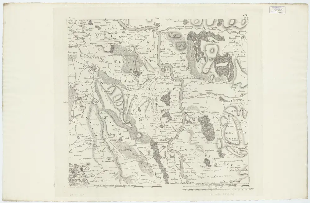
V ; 1.M., uit: Carte chorographique des Pays-Bas Autrichiens / ... par le Comte de Ferraris ; gravée par L.A. Dupuis

1 : 86400 Annotatie: Bladen linksboven genummerd met Romeinse cijfers, rechtsboven met een cijfer en een letter; Met opdracht aan keizer Joseph II (bl.XVI); Met plattegrond van Brussel (bl. XXI), overzichtskaart (bl. XXII) en bladwijzer (bl. XXIII); Annotatie geografische gegevens: Schaalstokken: Echelle de Toises ou de Lieues communes de France; Echelle de Verges ou de Lieues de Brabant; Echelle de Milles d'Allemagne (bl. XVII); Echelle de Mètres; In de hoeken lengte- en breedtematen T.M.e en T.P.e Joseph-Jean François Ferraris Comte de 1726-1814; L.A. Dupuis [S.l. : s.n.]
$title$

$title$

Dusseldorff undt Rheinberg

1 : 280000 Mollova mapová sbírka Person, Nikolaus Person, Nicolas
$title$

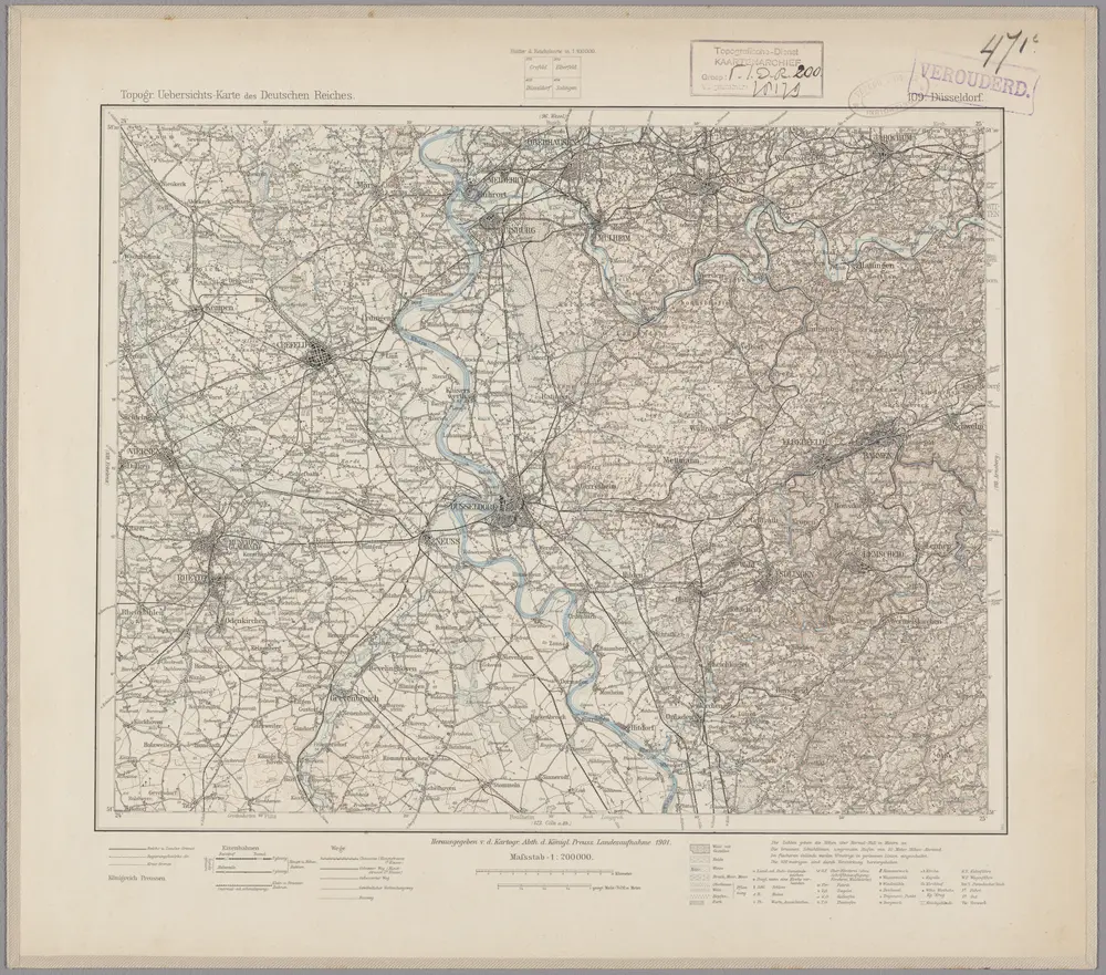
109. Düsseldorf, uit: Topographische Uebersichtskarte des Deutschen Reiches / herausgegeben v. d. Kartogr. Abt. d. Königl. Preuß. Landesaufnahme

1 : 200000 titelvariant: Topogr. Übersichtskarte des Deutschen Reiches; Annotatie: Titel boven bladen ook: Topogr. Übersichtskarte des Deutschen Reiches; Annotatie geografische gegevens: Op elk blad twee maatstokken: 10 Kilometer = 5,5 cm; 1 geogr. Meile = 3,6 cm; Legenda onder op elk blad Königlich Preußische Landesaufnahme. Kartographische Abtheilung [S.l : Königlich Preußische Landesaufnahme, Kartographische Abtheilung]
$title$

23me Helmont, uit: [Nouvelle carte de la Hollande, d'après Kraijenhoff et les meilleures cartes connus] / [Ph. Vandermaelen]

1 : 130000 Annotatie: Ontbreekt: bl. 1-12 Vandermaelen, Philippe Marie Guillaume Bruxelles : Établissement Géographique
$title$

TETRARCHIA | Ducatus Gelriæ | RVRÆMVNDENSIS

[Amsterdam : Joan Blaeu]
$title$

$title$

© MapTiler © OpenStreetMap contributors
How does it work?
These instructions will show you how to find historical maps online.
Getting started
Type the place name in the search box to find the exact location. You can further adjust the search by zooming in and out.
Zoom
Zoom in and out with the buttons or use your mouse or touchpad natively.
Exact Area tool
Click here and draw a rectangle over the map to precisely define the search area.
Set filters
Narrow your search with advanced settings, such as Years (from/to), Fulltext, Publisher, etc.
Results
See the results of your search on the right side. You can scroll down to find more maps of this location.
?

Download OldMapsOnline Mobile