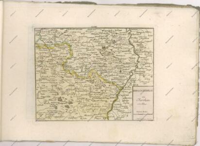
Maps of Vosges

12) VI.N.E. ''Mannheim'', uit: Carte géologique de France
1 : 500000 Annotatie: Voor aanwezige bladen zie bladoverzicht [S.l : s.n.]
Sect. 22: Strassburg i/E, uit: Geologische Karte des Deutschen Reichs in 27 Blaettern / [von] Richard Lepsius ; Red. von C. Vogel
1 : 500000 Annotatie: Blad 18 ontbreekt; Een aantal bladen op linnen; Een aantal bladen gereviseerd 1913-1914; Annotatie geografische gegevens: Met schaalstokken o.a. in kilometers; Legenda Carl Vogel 1828-1897 Gotha : Justus Perthes
Charte von dem königlich Bayerschen Kreise des Rhein
1 : 360000 Bavorsko (Německo) Blume, J. A. Pladt
Le Cours du Rhin depuis Strasbourg jusqu'a Worm et les Pays Adjacens
1 : 240000 Mollova mapová sbírka Delisle, Guillaume Liébaux L'Isle, Guillaume de
Palatinatus Rheni. [Karte], in: Gerardi Mercatoris Atlas, sive, Cosmographicae meditationes de fabrica mundi et fabricati figura, S. 358.
1 Karte aus Atlas Mercator, Gerhard Montanus, Petrus
Carte de Pais situéz entre la Moselle, La Saare, Le Rhein, Et La Basse Alsace [...] [Karte], in: Atlas nouveau, contenant toutes les parties du monde [...], Bd. 1, S. 232.
1 Karte aus Atlas Sanson, Nicolas Jaillot, Alexis Hubert und Mortier, Pieter
Neue General Kriegs Karte des Rheinstrohms
1 : 2700000 hrsg. von Johann Walch In Augsburg : im Willischen Kunstverlag
Neue general Kriegs Karte des Rheinstrohms
1 : 270000 Alsasko (Francie) Walch, Johann Iohann Walch im Willischen Kunstverlag
Cursus Rheni à Basilea usque ad Bonnam III. Sect.
1 : 260000 Mollova mapová sbírka Delisle, Guillaume Homann, Johann Baptista - dědici
Per Inclyti Circuli Suevici Supremorum Ordinum :
1 : 160000 Mollova mapová sbírka Pfeffel, Johann Andreas Homann, Johann Baptista - dědici
Per Inclyti Circuli Suevici Supremorum Ordinum :
1 : 160000 Mollova mapová sbírka Pfeffel, Johann Andreas Pfeffel, Johann Andreas I.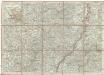
Charte der Laender am Rhein von Strasburg bis Mannheim
Mannheim (Německo) Mannert, Conrad Adam Gottlieb Schneider u. Weigels
Théatre de la Guerre ou Carte Nouvelle De le Cours du Rhin depuis Strasbourg jusqu'a Worms et Les Pays Adjacens
1 : 250000 Mollova mapová sbírka Delisle, Guillaume Ottens, Josua
Charte der Lænder am Rhein von Strasburg bis Mannheim
1 Karte : Kupferdruck ; 47 x 65 cm Mannert in der kays: priv. Kunsthandlung Adam Gottlieb Schneider u: Weigels

Exactissima Tabula Electoratuum Moguntini, Trevirensis et Palatini Episcopatuum Spirensis, et Wormatiensis Comitatuum Sarbruck, Ottweiler Bitsch Sarwerden Falckenstein, Leiningen, Veldentz et Super et Inferior Sponheim.
1 : 240000 Mollova mapová sbírka Person, Nikolaus Person, Nicolas

Cursus Rheni a Basilea usque ad Bonnam, III. sect. exhibitus
1 : 258000 Alsasko (Francie) Delisle, Guillaume per Homann. Heredes
Cursus Rheni a Basilea usque ad Bonnam, III. sect. exhibitus
1 : 258000 Alsasko (Francie) Delisle, Guillaume per Homann. Heredes
Generalkarte von Zentraleuropa

Le Theatre de Bellone :
Mollova mapová sbírka Schenk, Pieter Braakman, Adriaan
Exactissima Palatinatus ad Rhenum tabula
1 Karte : Kupferdruck ; 47 x 56 cm Homann Johann Baptist Homann
Exactissima Palatinatus ad Rhenum tabula
1 Karte : Kupferdruck ; 47 x 56 cm Homann Johann Baptist Homann
Elettorato e Palatinato del Reno
Mollova mapová sbírka Cantelli, Giacomo De Rossi, Giovanni Giacomo
Karten einiger an dem Ufer deß Rhein ligender Festungen worbey die Kaiserl. Byhler Hagenauer und Weissenburger Linien, wie auch die Battaille bey Hünninge und iezte Glorieuse Belagerung Landau angezeigt. alles mit sonderbahrem Fleiss gezeichentg
Německo Fuchs, Johann Conrad Jeremia Wolff
Palatinatus Rheni Nova, Et Accurata Descriptio
1 : 520000 Mollova mapová sbírka Visscher, Nicolaes Visscher, Nicolaus I.
Palatinatus Rheni nova, et accurata descriptio
1 : 520000 Frankfurt nad Mohanem (Německo) Visscher, Claes Jansz. per Nicolaum Joannis Piscatorem
Carte routière No. 27 Les bords du Rhin (de Mayence à Strasbourg), uit: Les bords du Rhin (de Mayence à Strasbourg)
1 : 350000 Paris : Taride