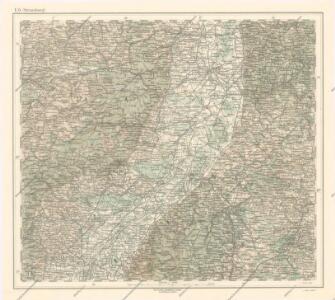
Maps of Regierungsbezirk Karlsruhe

Generalkarte von Zentraleuropa

Cursus Rheni a Basilea usque ad Bonnam, III. sect. exhibitus
1 : 258000 Alsasko (Francie) Delisle, Guillaume per Homann. Heredes
Cursus Rheni a Basilea usque ad Bonnam, III. sect. exhibitus
1 : 258000 Alsasko (Francie) Delisle, Guillaume per Homann. Heredes
Carte routière No. 27 Les bords du Rhin (de Mayence à Strasbourg), uit: Les bords du Rhin (de Mayence à Strasbourg)
1 : 350000 Paris : Taride
Le Theatre de Bellone :
Mollova mapová sbírka Schenk, Pieter Braakman, Adriaan
Per Inclyti Circuli Suevici Supremorum Ordinum :
1 : 160000 Mollova mapová sbírka Pfeffel, Johann Andreas Homann, Johann Baptista - dědici
Per Inclyti Circuli Suevici Supremorum Ordinum :
1 : 160000 Mollova mapová sbírka Pfeffel, Johann Andreas Pfeffel, Johann Andreas I.
Totius s.r.i. circuli Suevici tabula chorographica, 1
1 Blatt : R. et J. Ottens
Cursus Rheni à Basilea usque ad Bonnam III. Sect.
1 : 260000 Mollova mapová sbírka Delisle, Guillaume Homann, Johann Baptista - dědici
Totius S. R. I. Circuli Suevici Tabula Chorographica
1 : 310000 Mollova mapová sbírka Lamsvelt, Jan Ottens, Josua
Neue general Kriegs Karte des Rheinstrohms
1 : 270000 Alsasko (Francie) Walch, Johann Iohann Walch im Willischen Kunstverlag

Cursus Rheni infra Argentoratum usq; ad Wormatiam, cum adjacentibus Regionibus
1 : 2900000 Mollova mapová sbírka Seutter, Matthäus Seutter, Matthäus
Neue General Kriegs Karte des Rheinstrohms
1 : 2700000 hrsg. von Johann Walch In Augsburg : im Willischen Kunstverlag
Carte particulìere des pays quì sont sítuéz entre la Rhein, la Saare, la Mosselle et la basse Alsace, contenant partìe du Palatinat, des Electorats de Mayence de Treves des Eveschés de Spìres et de Wormes avec les Duchés de Deuxponts et des Sìmmeren.
from Atlas françois : contenant les cartes geographiques dans lesquelles sont tres exactement remarquez les empires, monarchies, royaumes et estats de l'Europe, de l'Asie, de l'Afrique et l'Amérique : avec les tables et cartes particulieres de France, de Flandre, d'Allemagne, d'Espagne et d'Italie / par ... Hubert Iaillot, geographe ordinaire ...

Generalkarte von Württemberg: Blatt I
1 : 1500000 Mit Übersichtskarte. Terrainzeichnung: Bach, Topograf und Hauptmann Lithografie: Rebmann und Sommer Herausgeber: K. statistisch-topografisches Büro
Le Palatinat et Electorat du Rhein
1 : 260000 Mollova mapová sbírka Sanson, Guillaume Goeree, Jan Jaillot, Alexis Hubert
Charte von dem königlich Bayerschen Kreise des Rhein
1 : 360000 Bavorsko (Německo) Blume, J. A. Pladt
Le Cours du Rhin depuis Strasbourg jusqu'a Worm et les Pays Adjacens
1 : 240000 Mollova mapová sbírka Delisle, Guillaume Liébaux L'Isle, Guillaume de
Carte du Palatinat et Electorat du Rhin
1 : 540000 Mollova mapová sbírka Desgranges
Carte Tres exacte du Theatre de la Guerre Sur le Rhein
Mollova mapová sbírka Briffaut, Etienne Briffaut, Etienne
Exactissima Palatinatus ad Rhenum tabula
1 Karte : Kupferdruck ; 47 x 56 cm Homann Johann Baptist Homann
Exactissima Palatinatus ad Rhenum tabula
1 Karte : Kupferdruck ; 47 x 56 cm Homann Johann Baptist Homann
Ducatus Wurtenbergici, 1
1 Blatt : Johann Baptist Homann
Elettorato e Palatinato del Reno
Mollova mapová sbírka Cantelli, Giacomo De Rossi, Giovanni Giacomo
12) VI.N.E. ''Mannheim'', uit: Carte géologique de France
1 : 500000 Annotatie: Voor aanwezige bladen zie bladoverzicht [S.l : s.n.]
Théatre de la Guerre ou Carte Nouvelle De le Cours du Rhin depuis Strasbourg jusqu'a Worms et Les Pays Adjacens
1 : 250000 Mollova mapová sbírka Delisle, Guillaume Ottens, Josua
Partie Orientale Du Palatinat et Eslectoriat Du Rhein. Les Eveschés De Spire, De Wormes et Le Comté De Linange. [Karte], in: Atlas nouveau, contenant toutes les parties du monde [...], Bd. 1, S. 184.
1 Karte aus Atlas Sanson, Nicolas Jaillot, Alexis Hubert und Mortier, Pieter
Carte topographique d'Allemagne
1 : 214500 Bádensko (Německo) Facius, Johann Gottlieb chez I.W.A. Iaeger