Maps of Rheinland-Pfalz

Carte de Pais situéz entre la Moselle, La Saare, Le Rhein, Et La Basse Alsace [...] [Karte], in: Atlas nouveau, contenant toutes les parties du monde [...], Bd. 1, S. 232.
1 Karte aus Atlas Sanson, Nicolas Jaillot, Alexis Hubert und Mortier, Pieter
Carte des Pais qui sont situez éntre la Moselle, la Saare, le Rhein, et la Basse Alsace
1 : 260000 Mollova mapová sbírka Sanson, Guillaume Jaillot, Alexis Hubert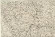
Totius Rheni â fontibus usque ad Ostia Novissima Descriptio
1 : 550000 Mollova mapová sbírka Steudner, Johann P. Bodenehr, Johann Georg Steüdner, Johann Philipp
Charte des Rhein-Stroms von Breisach bis Linz auch als Post- u. Reise-Charte der umliegenden Länder brauchbar
1 : 617000 Breisach am Rhein (Německo) Streit, Friedrich Wilhelm Joseph Engelmann
Abris Des Rheinstroms
Mollova mapová sbírka
Palatinatus Ad Rhenum. [Karte], in: Novus atlas absolutissimus, Bd. 2, S. 189.
1 Karte aus Atlas Janssonius Offizin
PALATINATVS | AD RHENVM.
Apud Guiljelmum Blaeu
Palatinatus Ad Rhenum [Karte], in: Novus Atlas, das ist, Weltbeschreibung, Bd. 1, S. 267.
1 Karte aus Atlas Blaeu, Joan Blaeu, Willem Janszoon
Palatinatus Ad Rhenum [Karte], in: Theatrum orbis terrarum, sive, Atlas novus, Bd. 1, S. 257.
1 Karte aus Atlas Blaeu, Joan Blaeu, Willem Janszoon
Le Palatinat Et Electorat Du Rhein Avec les Päis Voisins. [Karte], in: Atlas nouveau, contenant toutes les parties du monde [...], Bd. 1, S. 176.
1 Karte aus Atlas Sanson, Nicolas Jaillot, Alexis Hubert und Mortier, Pieter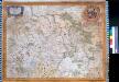
Palatinatvs Ad Rhenvm. Pfaltz. Heidelberg
Stenglin, Emanuel
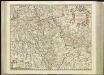
Exactissima Tabula Electoratuum Moguntini, Trevirensis et Palatini Episcopatuum Spirensis, et Wormatiensis Comitatuum Sarbruck, Ottweiler Bitsch Sarwerden Falckenstein, Leiningen, Veldentz et Super et Inferior Sponheim.
1 : 240000 Mollova mapová sbírka Person, Nikolaus Person, Nicolas
Cursus Rheni a Basilea usque ad Bonnam, III. sectionibus exhibitus
1 : 258000 Basilej (Švýcarsko) Delisle, Guillaume per Homannianos Heredes
Cursus Rheni a Basilea usque ad Bonnam, III. sectionibus exhibitus
1 : 258000 Basilej (Švýcarsko) Delisle, Guillaume per Homannianos Heredes
Palatinatus Ad Rhenum [Karte], in: Le théâtre du monde, ou, Nouvel atlas contenant les chartes et descriptions de tous les païs de la terre, Bd. 1, S. 296.
1 Karte aus Atlas Blaeu, Willem Janszoon und Blaeu, Joan Blaeu, Willem Janszoon
[55][55] Electoratus et Palatinatus Rheni ..., uit: Atlas sive Descriptio terrarum orbis
Annotatie: Gedigitaliseerde versie. Amsterdam. Heiloo : Picturae (vervaardiger), 2015. tiff-bestand. Gedigitaliseerd: 07-01-2015; Origineel: Universiteitsbibliotheek Vrije Universiteit (XL.05127.-) ; Netherlands; Titelpagina ontbreekt Wit, Frederik de Amsterdam : Frederick de Wit
Germania Prima sive Superior cujus Metropolis Moguntiacum
1 : 875000 Mollova mapová sbírka Sanson, Guillaume Sanson, Guillaume
Palatinatus Rheni nova et accurata descriptio / magna cura in lucem editum per Nicolaum Joannis Piscatorem
1 : 450000 Annotatie: Met stadsgezichten boven de kaart op Mentz en Francfurt am Main, onder op Spier, Heydelberg, Wormbs, links op Arcis Electoralis Palatinae delineatio, Dolium enormae magnitudinis, Neuberg Closter, rechts op Heyligenberg en Wolfs Brunnen; links en rechts elk 2 afb. van klederdrachten, rechts 1 wapen en onder 2 wapens; Origineel is Blad 109 in atlas factice Claes Jansz. Visscher 1586/1587-1652 [Amsterodami] : [Nicolaus Joannis Piscator]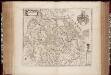
Palatinatvs ad Rhenvm
1 : 610000 Annotatie: Origineel is Blad 108 in atlas factice; Annotatie geografische gegevens: Met schaalstok: Germanica milliaria; Legenda Willem Jansz Blaeu 1571-1638 [Amsterdam : apud Guiljelmum Blaeu]
Neueste Karte und Richtige Vorstellung Aller Städte, Vestungen, Schlösser und remarquablen Ort, welche die Kron Frankreich zwischen dem Rhein, Saar, Mosel und im Elsaß wirklich besitzet
Mollova mapová sbírka Pfann, Wilhelm Ziegerkunst, Johann
Neueste Karte und Richtige Vorstellung Aller Städte, Vestungen, Schlösser und remarquablen Ort, welche die Kron Frankreich zwischen dem Rhein, Saar, Mosel und im Elsaß wirklich besitzet
Mollova mapová sbírka Pfann, Wilhelm
12) VI.N.E. ''Mannheim'', uit: Carte géologique de France
1 : 500000 Annotatie: Voor aanwezige bladen zie bladoverzicht [S.l : s.n.]
Palatinatus Rheni Nova, Et Accurata Descriptio
1 : 520000 Mollova mapová sbírka Visscher, Nicolaes Visscher, Nicolaus I.
Palatinatus Rheni nova, et accurata descriptio
1 : 520000 Frankfurt nad Mohanem (Německo) Visscher, Claes Jansz. per Nicolaum Joannis Piscatorem
Palatinatus Rheni. [Karte], in: Gerardi Mercatoris Atlas, sive, Cosmographicae meditationes de fabrica mundi et fabricati figura, S. 358.
1 Karte aus Atlas Mercator, Gerhard Montanus, Petrus
Carte de l'Archevesché et Electorat de Treves Avec Partie des Pays Adiacents
1 : 360000 Mollova mapová sbírka Bugnon, Didier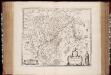
Archiepiscopatvs Trevirensis
1 : 370000 Annotatie: Origineel is Blad 105 in atlas factice; Annotatie geografische gegevens: Met 2 schaalstokken [Amsterdam : Joh. et Cornelius Blaeu exc]
Palatinatus Rheni
1 : 340000 Mollova mapová sbírka Schenk, Pieter Schenk, Peter II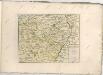
![Carte de Pais situéz entre la Moselle, La Saare, Le Rhein, Et La Basse Alsace [...] [Karte], in: Atlas nouveau, contenant toutes les parties du monde [...], Bd. 1, S. 232.](https://images-2.georeferencer.com/images/iiif/152148170719/full/,300/0/native.jpg)

