Maps of Shropshire
Map of Shropshire f. 75*
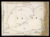
This is a manuscript map of Shropshire. It forms part of an atlat which belonged to Lord Burghley, Secretary of State to Elizabeth I, who used it to illustrate domestic matters. It shows only the principal towns, distinguishing between those with a castle and those without by means of a symbol of two connected towers with crenellations. The River Severn, marked Sabrina F, is charted. Lord Burghley has added a name adjacent to a place where the river is bridged. Lord Burghley was concerned with communication routes as revealed by his annotation. The draughtsman has indicated relief by hill symbols in two places. The map features a scale bar, but this is partly obscured by damage to the map.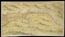
Bristol Channel and Severn Estuary
This is a chart showing the Bristol Channel and the River Severn. Sandbanks in the River Severn are indicated by stippling and the draughtsman has indicated the ‘Channell betweene the groundes’. The tributries of the Severn are indicated and figures along the banks record the distance in miles between their mouths. Locations of note, such as Bristol, Bath and Newport are represented by generalised perspective views of houses and churches. The map is thought to date from 1595, reflecting the fear that the Spanish were planning to invade the Bristol Channel in the 1590’s, rather than initiate a more obvious and direct attack via the English Channel. The Anglo- Spanish relationship had steadily deteriorated since the accession of the Protestant Elizabeth I. Raids on transatlantic shipping by English seamen such as Francis Drake and England’s support of the Protestant rebellion in the Spanish ruled Netherlands had brought tensions with Spain to a crescendo culminating in the events of the Spanish Armada. Although the Spanish Armada was defeated by the English in 1588, England remained at war with Spain for many years and further attempts to invade were made by Philip II. In 1595, the year this chart was produced, the Spanish attacked Mounts Bay, Newlyn and Penzance.
An accurate map of Shrop Shire
1 Karte : Kupferdruck ; 51 x 68 cm Bowen; Hinton sold by J. Hinton at the Kings Arms in St. Pauls Church Yard
Comitatvs Salopiensis; anglice Shrop Shire
1 Karte : Kupferdruck ; 37 x 48 cm Blaeu Joan Blaeu
Comitatus Salopiensis; Anglice Shrop Shire. [Karte], in: Theatrum orbis terrarum, sive, Atlas novus, Bd. 4, S. 374.
1 Karte aus Atlas Blaeu, Joan Blaeu, Willem Janszoon
Comitatus Salopiensis; Anglice Shrop Shire. [Karte], in: Theatrum orbis terrarum, sive, Atlas novus, Bd. 4, S. 374.
1 Karte aus Atlas Blaeu, Joan Blaeu, Willem Janszoon
A New and accurate map of Radnor Shire
1 : 237600
Comitatus Salopiensis; Anglice Shrop Shire. [Karte], in: Le théâtre du monde, ou, Nouvel atlas contenant les chartes et descriptions de tous les païs de la terre, Bd. 4, S. 322.
1 Karte aus Atlas Blaeu, Willem Janszoon und Blaeu, Joan Blaeu, Willem Janszoon
HEREFORDIA | COMITATVS. | HEREFORD-SHIRE.
[Amsterdam : Joan Blaeu]
SALOPIAE COMITATUS Sheet 22
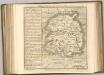
This map of Shropshireis from the 1583 edition of the Saxton atlas of England and Wales.This atlas was first published as a whole in 1579. It consists of 35 coloured maps depicting the counties of England and Wales. The atlas is of great significance to British cartography as it set a standard of cartographic representation in Britain and the maps remained the basis for English county mapping, with few exceptions, until after 1750. During the reign of Elizabeth I map use became more common, with many government matters referring to increasingly accurate maps with consistent scales and symbols, made possible by advances in surveying techniques. Illustrating the increasing used of maps in government matters, Lord Burghley, Elizabeth I’s Secretary of State, who had been determined to have England and Wales mapped in detail from the 1550s, selected the cartographer Christopher Saxton to produce a detailed and consistent survey of the country. The financier of the project was Thomas Seckford Master of Requests at the Court of Elizabeth I, whose arms appear, along with the royal crest, on each map. Saxton, Christopher Ryther, Augustine
COMITATVS | SALOPIENSIS; | Anglice | SHROP SHIRE.
[Amsterdam : Joan Blaeu]
SALOPIAE COMITATUS f.86
This is a map of Shropshire by Christopher Saxton dating from 1577. It forms part of an atlas that belonged to William Cecil Lord Burghley, Elizabeth I’s Secretary of State. Burghley used this atlas to illustrate domestic matters. This map is actually a proof copy of one which forms part of Christopher Saxton’s Atlas of England and Wales. This atlas was first published as a whole in 1579. It consists of 35 coloured maps depicting the counties of England and Wales. The atlas is of great significance to British cartography as it set a standard of cartographic representation in Britain and the maps remained the basis for English county mapping, with few exceptions, until after 1750. During the reign of Elizabeth I, map use became more common, with many government matters referring to increasingly accurate maps with consistent scales and symbols, made possible by advances in surveying techniques. Illustrating the increasing use of maps in government matters, Lord Burghley, who had been determined to have England and Wales mapped in detail from the 1550s, selected the cartographer Christopher Saxton to produce a detailed and consistent survey of the country. The financier of the project was Thomas Seckford Master of Requests at the Court of Elizabeth I, whose arms appear, along with the royal crest, on each map. Burghley has annotated this map, adding several place names. The map was engraved by Remigius Hogenbergius, one of a team of seven English and Flemish engravers employed to produced the copper plates for the atlas. Saxton, Christopher Hogenbergius, Remigius
Herefordia Comitatus. Hereford-Shire. [Karte], in: Theatrum orbis terrarum, sive, Atlas novus, Bd. 4, S. 393.
1 Karte aus Atlas Blaeu, Joan Blaeu, Willem Janszoon
Herefordia Comitatus. Hereford-Shire. [Karte], in: Theatrum orbis terrarum, sive, Atlas novus, Bd. 4, S. 393.
1 Karte aus Atlas Blaeu, Joan Blaeu, Willem Janszoon
Herefordia Comitatus. Hereford-Shire. [Karte], in: Le théâtre du monde, ou, Nouvel atlas contenant les chartes et descriptions de tous les païs de la terre, Bd. 4, S. 339.
1 Karte aus Atlas Blaeu, Willem Janszoon und Blaeu, Joan Blaeu, Willem Janszoon
Herefordia Comitatus vernacule Hereford Shire
1 : 280000 Amstelodami : apud Joannem Janssonium
HEREFORDIAE COMITATUS f.95
This is a map of Herefordshire by Christopher Saxton dating from 1577. It forms part of an atlas that belonged to William Cecil Lord Burghley, Elizabeth I’s Secretary of State. Burghley used this atlas to illustrate domestic matters. This map is actually a proof copy of one which forms part of Christopher Saxton’s Atlas of England and Wales. This atlas was first published as a whole in 1579. It consists of 35 coloured maps depicting the counties of England and Wales. The atlas is of great significance to British cartography as it set a standard of cartographic representation in Britain and the maps remained the basis for English county mapping, with few exceptions, until after 1750. During the reign of Elizabeth I, map use became more common, with many government matters referring to increasingly accurate maps with consistent scales and symbols, made possible by advances in surveying techniques. Illustrating the increasing use of maps in government matters, Lord Burghley, who had been determined to have England and Wales mapped in detail from the 1550s, selected the cartographer Christopher Saxton to produce a detailed and consistent survey of the country. The financier of the project was Thomas Seckford, Master of Requests at the Court of Elizabeth I, whose arms appear, along with the royal crest, on each map. Burghley has annotated this map, underlining the information printed at Kinnaston chap Wch Was dreven downe by the removing of the ground. The map was engraved by Remigius Hogenbergius, one of a team of seven English and Flemish engravers employed to produce the copper plates for the atlas. Saxton, Christopher Hogenbergius, Remigius
Herefordia Comitatus vernacule Hereford Shire. [Karte], in: Novus atlas absolutissimus, Bd. 7, S. 376.
1 Karte aus Atlas Janssonius Offizin
HEREFORDIAE COMITATUS Sheet 23
This map of Herefordshire is from the 1583 edition of the Saxton atlas of England and Wales. This atlas was first published as a whole in 1579. It consists of 35 coloured maps depicting the counties of England and Wales. The atlas is of great significance to British cartography as it set a standard of cartographic representation in Britain and the maps remained the basis for English county mapping, with few exceptions, until after 1750. During the reign of Elizabeth I map use became more common, with many government matters referring to increasingly accurate maps with consistent scales and symbols, made possible by advances in surveying techniques. Illustrating the increasing used of maps in government matters, Lord Burghley, Elizabeth I’s Secretary of State, who had been determined to have England and Wales mapped in detail from the 1550s, selected the cartographer Christopher Saxton to produce a detailed and consistent survey of the country. The financier of the project was Thomas Seckford Master of Requests at the Court of Elizabeth I, whose arms appear, along with the royal crest, on each map. Here Saxton’s name appears in the decorative scale bar, as does the name of the engraver of this map, Remigius Hogenberg , one of seven English and Flemish engravers employed to produced the copper plates for the atlas. The cartouche is mounted by the Elizabethan coat of arms and the Seckford arms of appear in the bottom right corner. The adjacent counties are named but lack any internal detail, recording only the path of rivers that cross county boundaries. Saxton, Christopher Ryther, Augustine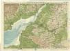
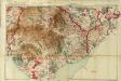
Bath & Bristol, Sheet 28 - Bartholomew's "Half Inch to the Mile Maps" of England & Wales
1 : 126720 Topographic maps Bartholomew, John George John Bartholomew & Co
An accurate map of the counties Gloucester and Monmouth
1 Karte : Kupferdruck ; 51 x 66 cm Tinney; Bowles; Sayer; Bowles; Bowles printed for T. Bowles in St. Pauls Church Yard Rob.t Sayer and John Tinney in Fleet Street and John Bowles and son in Cornhil
Hereford, Sheet 23 - Bartholomew's "Half Inch to the Mile Maps" of England & Wales
1 : 126720 Topographic maps Bartholomew, John George John Bartholomew & Co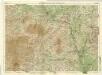
Shropshire, Sheet 17 - Bartholomew's "Half Inch to the Mile Maps" of England & Wales
1 : 126720 Topographic maps Bartholomew, John George John Bartholomew & Co
Glocestria Ducatus, cum Monumethensi Comitatu = Glocester Shire & Monmouth Shire
1 : 280000 [Amstelodami] : [apud Joannem Janssonium]
South Wales and the border in the 14th century
Rees, William Ordnance Survey
Glocestria dvcatvs, Monvmethensi comitatu
1 Karte : Kupferdruck ; 39 x 49 cm Valck; Schenk penes G. Valk et P. Schenk
Monumethensis Comitatus. Vernacule Monmouth Shire. [Karte], in: Theatrum orbis terrarum, sive, Atlas novus, Bd. 4, S. 404.
1 Karte aus Atlas Blaeu, Joan Blaeu, Willem Janszoon