Maps of Herefordshire
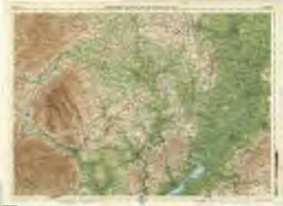
Hereford, Sheet 23 - Bartholomew's "Half Inch to the Mile Maps" of England & Wales
1 : 126720 Topographic maps Bartholomew, John George John Bartholomew & Co
Herefordia Comitatus vernacule Hereford Shire. [Karte], in: Novus atlas absolutissimus, Bd. 7, S. 376.
1 Karte aus Atlas Janssonius Offizin
Herefordia Comitatus vernacule Hereford Shire
1 : 280000 Amstelodami : apud Joannem Janssonium
Herefordia Comitatus. Hereford-Shire. [Karte], in: Theatrum orbis terrarum, sive, Atlas novus, Bd. 4, S. 393.
1 Karte aus Atlas Blaeu, Joan Blaeu, Willem Janszoon
Herefordia Comitatus. Hereford-Shire. [Karte], in: Theatrum orbis terrarum, sive, Atlas novus, Bd. 4, S. 393.
1 Karte aus Atlas Blaeu, Joan Blaeu, Willem Janszoon
Herefordia Comitatus. Hereford-Shire. [Karte], in: Le théâtre du monde, ou, Nouvel atlas contenant les chartes et descriptions de tous les païs de la terre, Bd. 4, S. 339.
1 Karte aus Atlas Blaeu, Willem Janszoon und Blaeu, Joan Blaeu, Willem Janszoon
HEREFORDIAE COMITATUS f.95
This is a map of Herefordshire by Christopher Saxton dating from 1577. It forms part of an atlas that belonged to William Cecil Lord Burghley, Elizabeth I’s Secretary of State. Burghley used this atlas to illustrate domestic matters. This map is actually a proof copy of one which forms part of Christopher Saxton’s Atlas of England and Wales. This atlas was first published as a whole in 1579. It consists of 35 coloured maps depicting the counties of England and Wales. The atlas is of great significance to British cartography as it set a standard of cartographic representation in Britain and the maps remained the basis for English county mapping, with few exceptions, until after 1750. During the reign of Elizabeth I, map use became more common, with many government matters referring to increasingly accurate maps with consistent scales and symbols, made possible by advances in surveying techniques. Illustrating the increasing use of maps in government matters, Lord Burghley, who had been determined to have England and Wales mapped in detail from the 1550s, selected the cartographer Christopher Saxton to produce a detailed and consistent survey of the country. The financier of the project was Thomas Seckford, Master of Requests at the Court of Elizabeth I, whose arms appear, along with the royal crest, on each map. Burghley has annotated this map, underlining the information printed at Kinnaston chap Wch Was dreven downe by the removing of the ground. The map was engraved by Remigius Hogenbergius, one of a team of seven English and Flemish engravers employed to produce the copper plates for the atlas. Saxton, Christopher Hogenbergius, Remigius
HEREFORDIA | COMITATVS. | HEREFORD-SHIRE.
[Amsterdam : Joan Blaeu]
HEREFORDIAE COMITATUS Sheet 23
This map of Herefordshire is from the 1583 edition of the Saxton atlas of England and Wales. This atlas was first published as a whole in 1579. It consists of 35 coloured maps depicting the counties of England and Wales. The atlas is of great significance to British cartography as it set a standard of cartographic representation in Britain and the maps remained the basis for English county mapping, with few exceptions, until after 1750. During the reign of Elizabeth I map use became more common, with many government matters referring to increasingly accurate maps with consistent scales and symbols, made possible by advances in surveying techniques. Illustrating the increasing used of maps in government matters, Lord Burghley, Elizabeth I’s Secretary of State, who had been determined to have England and Wales mapped in detail from the 1550s, selected the cartographer Christopher Saxton to produce a detailed and consistent survey of the country. The financier of the project was Thomas Seckford Master of Requests at the Court of Elizabeth I, whose arms appear, along with the royal crest, on each map. Here Saxton’s name appears in the decorative scale bar, as does the name of the engraver of this map, Remigius Hogenberg , one of seven English and Flemish engravers employed to produced the copper plates for the atlas. The cartouche is mounted by the Elizabethan coat of arms and the Seckford arms of appear in the bottom right corner. The adjacent counties are named but lack any internal detail, recording only the path of rivers that cross county boundaries. Saxton, Christopher Ryther, Augustine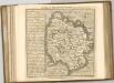

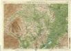
Hereford - OS One-Inch Map
1 : 63360 Topographic maps Ordnance Survey Ordnance Survey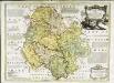
An accurate map of Hereford Shire
1 Karte : Kupferdruck ; 51 x 69 cm Bowen; Tinney sold by I. Tinney at the Golden Lion in Fleet street
Herefordia comitatvs
1 Karte : Kupferdruck ; 39 x 48 cm Blaeu Joan Blaeu
Gloucester and Malvern - OS One-Inch Map
1 : 63360 Topographic maps Ordnance Survey Ordnance Survey
Monvmethensis comitatvs vernacule Monmovth Shire
1 Karte : Kupferdruck ; 37 x 48 cm Blaeu Joan Blaeu
Weobly
1 : 31680 The right-hand portion of this manuscript features several annotated red crosses. These represent observation and trigonometrical stations from which angular measurements were been taken. To the far left, red-ink lines describe the Monmouth River, highlighting it as the boundary separating Herefordshire and Monmothshire. The borders of the published sheet can be seen in pencil. Budgen, Thomas
Usk(002OSD000000003U00162000)
1 : 31680 .The Monnow Valley, down the right side of the sheet, forms a natural break in defences along the border of southern Wales.,Depicted along the valley are the Norman,castles of Grosmont, Skenfirth, Tregets and Monmouth, which,once guarded the routes between Herefordshire and Wales. ,Monmouth was of particular importance, lying exactly on the border where the river Monnow joins the Wye. Iron roads, the horse railroads pre-dating the locomotive era, feature at lower right. Highlighted,in ochre, these were probably added,to the plan some time after its official completion. Budgen Charles
New map of the county of Hereford, 3
1 Blatt : 71 x 58 cm s.n.
New map of the county of Hereford, 4
1 Blatt : 71 x 58 cm s.n.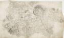
Hereford 22
1 : 31680 Below the city of Hereford, near the top of the sheet, the River Wye flows,through a winding river channel,across a broad floodplain with few major settlements. The floodplain is mostly farmland, dotted by,very small areas of woodland and marsh., The main river banks are lined irregularly with tall alder and willow trees, illustrated on this plan. Budgen, Thomas
Hay
1 : 31680 Pencil lines radiating from fixed points indicate trigonometric measurements made to plot features of the landscape. These are particularly evident at the margins of the drawing, where they are annotated by place names. Budgen
Hay (Hills) - OS One-Inch Revised New Series
1 : 63360 Topographic maps Ordnance Survey Ordnance Survey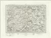
Hay (Outline) - OS One-Inch Revised New Series
1 : 63360 Topographic maps Ordnance Survey Ordnance Survey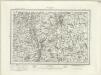
Worcester (Outline) - OS One-Inch Revised New Series
1 : 63360 Topographic maps Ordnance Survey Ordnance Survey
Worcester (Hills) - OS One-Inch Revised New Series
1 : 63360 Topographic maps Ordnance Survey Ordnance Survey
Talgarth (Hills) - OS One-Inch Revised New Series
1 : 63360 Topographic maps Ordnance Survey Ordnance Survey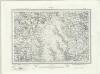
Talgarth (Outline) - OS One-Inch Revised New Series
1 : 63360 Topographic maps Ordnance Survey Ordnance Survey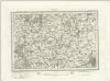
Tewksbury (Outline) - OS One-Inch Revised New Series
1 : 63360 Topographic maps Ordnance Survey Ordnance Survey
Tewksbury (Hills) - OS One-Inch Revised New Series
1 : 63360 Topographic maps Ordnance Survey Ordnance Survey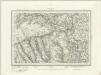
Abergavenny (Outline) - OS One-Inch Revised New Series
1 : 63360 Topographic maps Ordnance Survey Ordnance Survey