Maps of Southern Transdanubia

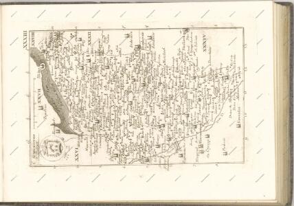
C. Sümeghiensis
Ungarn Komitat Somogy
Siedlungsgebiet der Deutschen nach dem Nachbarschaftsindex für Süd-Transdanubien 1880
Ungarn (Süd) Deutsche, Siedlung Bottlik, Zsolt
Siedlungsgebiet der Deutschen nach dem Nachbarschaftsindex für Süd-Transdanubien 1941
Ungarn (Süd) Deutsche, Siedlung Bottlik, Zsolt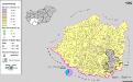
Siedlungsgebiet der Deutschen nach dem Nachbarschaftsindex für Süd-Transdanubien 1980
Ungarn (Süd) Deutsche, Siedlung Bottlik, Zsolt
Comitat Somogy
1 : 300000
Somogy vármegye térképe
1 : 400000 Kaposvár (Maďarsko) Kogutowicz, Manó Magyar Földrajzi Intézet
Szalader com[it.] Schackmin Cvrassie Regiments
1 : 467000 Balaton-oblast (Maďarsko) Cir, V.
Belovar
1 : 200000 Bjelovar (Chorvatsko : oblast) Kartografska radionica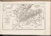
C. Szaladiensis. Tab. III
Ungarn Komitat Zala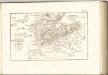
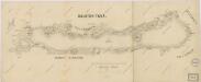
Balaton Tava

Nagy-Atad und Szigetvar.
from Spezialkarte der osterreichisch-ungarischen Monarchie.
Kaposvar und Bohonye.
from Spezialkarte der osterreichisch-ungarischen Monarchie.
Somogyvar.
from Spezialkarte der osterreichisch-ungarischen Monarchie.
Funfkirchen.
from Spezialkarte der osterreichisch-ungarischen Monarchie.
Tamasi und Igal.
from Spezialkarte der osterreichisch-ungarischen Monarchie.
Dombovar.
from Spezialkarte der osterreichisch-ungarischen Monarchie.
Nagy-Atád
1 : 75000 Nagyatád, Komitat Somogy
Fünfkirchen
1 : 75000 Pécs
Dombovár
1 : 75000 Dombóvár, Komitat Tolna
Tamási
1 : 75000 Tamási, Komitat Tolna
Somogyvár
1 : 75000 Somogyvár, Komitat Somogy
Kaposvár
1 : 75000 Kaposvár
Barcs und Virovitica.; Spezialkarte der osterreichisch-ungarischen Monarchie.
from Spezialkarte der osterreichisch-ungarischen Monarchie. Austro-Hungarian Monarchy. Militärgeographisches Institut.,
Harkany und Miholjac-Dolnji.; Spezialkarte der osterreichisch-ungarischen Monarchie.
from Spezialkarte der osterreichisch-ungarischen Monarchie. Austro-Hungarian Monarchy. Militärgeographisches Institut.,
Harkány
1 : 75000 Harkány
Nagy-Vázsony
1 : 75000 Nagyvázsony, Komitat Veszprém
Balaton-Füred
1 : 75000 Balatonfüred, Umland