Maps of Zala

Maps of Zala

$title$

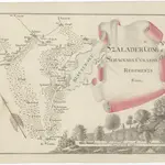
Szalader com[it.] Schackmin Cvrassie Regiments

1 : 467000 Balaton-oblast (Maďarsko) Cir, V.
$title$

C. Szaladiensis. Tab. III

Ungarn Komitat Zala
$title$

$title$

Somogy vármegye térképe

1 : 400000 Kaposvár (Maďarsko) Kogutowicz, Manó Magyar Földrajzi Intézet
$title$

Comitat Somogy

1 : 300000
$title$

Balaton Tava

$title$

Balaton turistická mapa

$title$

Balaton und Umgebung

1 : 200000 Balaton (Maďarsko : jezero : oblast) M. Kir. Állami Térképészet
$title$

Sumeg und Zala-Egerszeg.

from Spezialkarte der osterreichisch-ungarischen Monarchie.
$title$

Nagyvazsony und Badacsonytomaj.

from Spezialkarte der osterreichisch-ungarischen Monarchie.
$title$

Kis-Komarom und Zala-Szt.-Mihaly.

from Spezialkarte der osterreichisch-ungarischen Monarchie.
$title$

Somogyvar.

from Spezialkarte der osterreichisch-ungarischen Monarchie.
$title$

Tamasi und Igal.

from Spezialkarte der osterreichisch-ungarischen Monarchie.
$title$

Balatonfured und Varos-Hidveg.

from Spezialkarte der osterreichisch-ungarischen Monarchie.
$title$

Tamási

1 : 75000 Tamási, Komitat Tolna
$title$

Somogyvár

1 : 75000 Somogyvár, Komitat Somogy
$title$

Nagy-Vázsony

1 : 75000 Nagyvázsony, Komitat Veszprém
$title$

Balaton-Füred

1 : 75000 Balatonfüred, Umland
$title$

Sümeg

1 : 75000 Sümeg, Komitat Veszprém
$title$

Kis-Komárom

1 : 75000 Komorn (Ungarn)
$title$

Badacsonytomaj

1 : 25000 Maďarsko MM. Kir. Állami Térképészet
$title$

Siófok, Balatonkiliti-Vilmatelep

1 : 10000 M. Kir. Állami Térképészet
$title$

Tihanyi félsziget

1 : 20000 M. Kir. Állami Térképészet
$title$

Balatonfüredfürdo

1 : 10000 M. Kir. Állami Térképszet
$title$

Balaton

$title$

A németek településterülete a szomszédsági mutató alapján Dél-Dunántúlon 1941-ban

Ungarn (Süd) Deutsche, Siedlung Bottlik, Zsolt
$title$

A németek településterülete a szomszédsági mutató alapján Dél-Dunántúlon 1880-ban

Ungarn (Süd) Deutsche, Siedlung Bottlik, Zsolt
$title$

A németek településterülete a szomszédsági mutató alapján Dél-Dunántúlon 1980-ban

Ungarn (Süd) Deutsche, Siedlung Bottlik, Zsolt
$title$

A horvátok aránya és száma Délnyugat-Magyarországon 1941-ben

Transdanubien (Süd) Kroaten, Siedlung Bottlik, Zsolt
$title$

A horvátok aránya és száma Délnyugat-Magyarországon 1980-ben

Transdanubien (Süd) Kroaten, Siedlung Bottlik, Zsolt
© MapTiler © OpenStreetMap contributors
How does it work?
These instructions will show you how to find historical maps online.
Getting started
Type the place name in the search box to find the exact location. You can further adjust the search by zooming in and out.
Zoom
Zoom in and out with the buttons or use your mouse or touchpad natively.
Exact Area tool
Click here and draw a rectangle over the map to precisely define the search area.
Set filters
Narrow your search with advanced settings, such as Years (from/to), Fulltext, Publisher, etc.
Results
See the results of your search on the right side. You can scroll down to find more maps of this location.
?

Download OldMapsOnline Mobile