Maps of Dnieper Upland

Typus Generalis Ukrainae sive Palatinatuum Podoliae, Kioviensis et Braczlaviensis terras nova delineatione ex hibens. [Karte], in: Novus atlas absolutissimus, Bd. 1, S. 104.
1 Karte aus Atlas Janssonius Offizin
[Střední Ukrajina]
Ukrajina
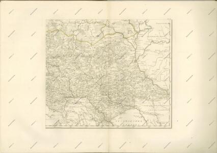
Li Palatinati di Braclaw

VIII, uit: General-Karte von Mittel-Europa in 12 Blättern, im Masse 1:1.200.000 / entworfen, bearb. und hrsg. von Josef Schlacher
1 : 1200000 Annotatie: Blad 6 ontbreekt; Annotatie geografische gegevens: 21 maatstokken op blad 9; Legenda op blad 9 Wien : K.K. Militär Geografisches Institut
Partie, Russie d'Europe. Europe 15.
1 : 1641836 Vandermaelen, Philippe, 1795-1869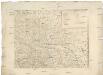
[Západní Ukrajina]
Ukrajina západní Benedicti, Hieronymus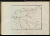
Karta putej dviženīja armīi Minicha v 1739 g.
Ukraine Černivci Krieg Minich, Burchard-Christofor

Théatre de la guerre actuelle, en Allemagne, en Pologne et en Turquie. n5, Brody
1 : 900000 Chanlaire, Pierre Grégoire 1758-1817 Paris : chez l'auteur P. G. Chanlaire
Basse Volhynie, ou palatinat de Kiow / tiré entierement de la gra[n]de Ukraine, du Sieur le Vasseur
1 : 875000 1 Karte : Kupferdruck ; 41 x 56 cm Sanson, Nicolas chez P. Mariette
Die Gegend zwischen Pultava und Bender Mitt Angraenzenden Polnisch, Türkisch und Tartarischen Lands
1 : 2000000 1 Karte : Kupferdruck ; 16 x 29 cm Bodenehr, Gabriel [Verlag nicht ermittelbar]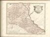

Die Gegend zwischen Pultava und Bender mit angraenzenden Polnisch, Türkisch und Tartarischen Landschaften
1 : 2640000 Poltava (Ukrajina) Bodenehr, Gabriel Gabriel Bodenehr
Théatre de la guerre actuelle, en Allemagne, en Pologne et en Turquie. n12, Iassi
1 : 900000 Chanlaire, Pierre Grégoire 1758-1817 Paris : chez l'auteur P. G. Chanlaire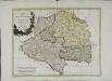
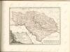
Li palatinati della Russia rossa Podolia e Wolhynia
1 Karte : Kupferdruck ; 31 x 40 cm Zatta; Zuliani; Pitteri; Rizzi-Zannoni presso Antonio Zatta
Li palatinati della Russia rossa Podolia e Wolhynia / tratta dall'atlante polac[c]o del Sig[no]r Riz
1 : 1500000 1 Karte : Kupferdruck ; 31 x 40 cm Zuliani, Giuliano presso Antonio Zatta
Galizien und das Fürstentum Moldau (16./17. Jahrhundert)
Moldau (Fürstentum), Galizien
Gipsometričeskaja karta Polěs'ja s oboznačenijem kanalizacii
1 : 1250000 Polesí
Geologičeskaja karta Polěs'ja
1 : 1250000 Polesí
Karte von Bessarabien, Podolien und den angrenzenden Ländern
1 : 900000 entworfen und gezeichnet von F. Handtke Glogau : C. Flemming
Internationale Weltkarte. M - 36 Kijev

Europe 1:1,000,000, Kiev
Sheet including Ukraine from the map series: Europe. Scale, 1 :1,000,000. [Including Asia Minor, Mesopotamia, etc.] Provisional edition. Compiled at the Royal Geographical Society ... drawn and printed by the Ordnance Survey G.S.G.S. No. 2758. London : Geographical Section, General Staff.
Übersichtskarte von Mittel - Europa

Übersichtskarte von Mittel - Europa

Bez titulu: Šest listů speciálních map Ukrajiny

Carte de la Roumanie et pays limitrophes. Balta
1 : 500000 France. Service géographique de l'armée [Paris] : Service géographique de l'armée
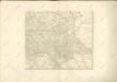
Li palatinati di Braclaw, e Kiowia / tratta dall'atlante polacco del Sig.r Rizzi Zanoni ; G. Zuliani
1 : 740000 1 Karte : Kupferdruck ; 40 x 31 cm Zuliani, Giuliano presso Antonio Zatta
Bałta, Umań, Bracław
1 : 750000 Braslaw (Bělorusko : oblast) Mach, O. K. u. k. Militärgeographisches Institut