Maps of Moldova

VIII, uit: General-Karte von Mittel-Europa in 12 Blättern, im Masse 1:1.200.000 / entworfen, bearb. und hrsg. von Josef Schlacher
1 : 1200000 Annotatie: Blad 6 ontbreekt; Annotatie geografische gegevens: 21 maatstokken op blad 9; Legenda op blad 9 Wien : K.K. Militär Geografisches Institut
Trigonometrisk grunnlag, vedlegg 65, 1c: Grunnlagspunkter for Struves meridianbue fra Hrodna til Odessa
1 : 1440000

Danvbivs, Fluvius Europae Maximus
Mollova mapová sbírka Danckertsz, Cornelis Danckerts, Cornelis I. - dědici
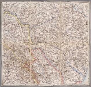
Karte der Moldau und der angrenzenden Länder Oesterreichs (Ostgalizien und Siebenbürgen), Russlands (Bessarabien, Podolien, Volhynien, Kiew), dann der Wallachei und Dobrudscha
1 : 1500000 Besarábie (Moldavsko a Ukrajina)
Österreich-Ungarische Monarchie
1 : 1000000 Evropa jihovýchodní R. Lechner
Tabula Geographica
1 : 1600000 Mollova mapová sbírka Homann, Johann Baptist Homann, Johann Baptista - dědici

Théatre de la guerre actuelle, en Allemagne, en Pologne et en Turquie. n12, Iassi
1 : 900000 Chanlaire, Pierre Grégoire 1758-1817 Paris : chez l'auteur P. G. Chanlaire
[Západní Ukrajina]
Ukrajina západní Benedicti, Hieronymus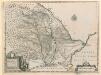
Principatus Moldaviae descriptio
Principatus Moldaviae descriptio, delineante Principe Demetrio Cantemirio. Changuion
Galizien und das Fürstentum Moldau (16./17. Jahrhundert)
Moldau (Fürstentum), Galizien
Tabula geographica continens despotatus Wallachiae atque Moldaviae, provinciam Bessarabiae sub clientela Turcica, itemque provinciam polonicam Podoliae
1 : 1500000 Besarábie (Moldavsko a Ukrajina) ab Homannianis Heredibus
Karte von Bessarabien, Podolien und den angrenzenden Ländern
1 : 900000 entworfen und gezeichnet von F. Handtke Glogau : C. Flemming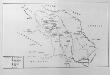
Die Moldau
Moldau (Fürstentum)
Charte von Bessarabien
1 : 1637000 Besarábie (Moldavsko a Ukrajina) Schlieben Gleditsch
Moldau, historisch
Moldau (Fürstentum), Bessarabien Zwick, J.
Bessarabien
Bessarabien, Moldau
Gipsometričeskaja karta Polěs'ja s oboznačenijem kanalizacii
1 : 1250000 Polesí
Karte von der Moldau, Wallachei u. Siebenbürgen nebst Theilen der angränzenden Länder
1 : 1863880 Moldavsko Handtke, Friedrich Flemming, C. C. Flemming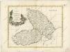
Principati di Moldavia

Principatus Valachiae, Moldaviae, et Transylvaniae, divisus in singulares Populos cum finitimis Regionibus distinete ostenduntur
1 : 1100000 Mollova mapová sbírka Valk, Gerhard Valck, Gerard
Geologičeskaja karta Polěs'ja
1 : 1250000 Polesí
[Střední Ukrajina]
Ukrajina
Karta putej dviženīja armīi Minicha v 1739 g.
Ukraine Černivci Krieg Minich, Burchard-Christofor

Moldau um 1930. Stadtbevölkerung
Moldawien ethnische Gruppe, Stadtbevölkerung Hofinger, Veronika
Moldau um 1930. Juden
Moldawien ethnische Gruppe, Juden Hofinger, Veronika
Moldau um 1930. Zigeuner
Moldawien ethnische Gruppe, Roma