Maps of Dumfries and Galloway

Charte von England und Wallis, 1
1 Blatt : 62 x 53 cm Walch
Karte von England und Wallis, 1
1 Blatt : 63 x 54 cm Schrämbl
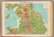
England & Wales NW.
1 : 633600 Stanford, Edward
Westmorlandia, Lancastria, Cestria, Caernarvan, Denbigh, Flint, Merionidh, Montogomery, Salopia Cum insulis Mania Et Anglesey. [Karte], in: Atlas, sive, Cosmographicae meditationes de fabrica mundi et fabricati figura, S. 113.
1 Karte aus Atlas Mercator, Gerhard
Westmorlandia, Lancastria, Cestria, Caernarvan, Denbigh, Flint, Merionidh, Montogomery, Salopia Cum insulis Mania Et Anglesey. [Karte], in: Gerardi Mercatoris Atlas, sive, Cosmographicae meditationes de fabrica mundi et fabricati figura, S. 115.
1 Karte aus Atlas Mercator, Gerhard Montanus, Petrus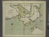
A chart of the sea coast of IRELAND from Dublin to London-Derry
from The sea-atlas : containing an hydrographical description of most of the sea-coasts of the known parts of the world.
Watershed map England, Wales 1.
1 : 760320 Letts, Son & Co.
England and Wales. England No. 2.
1 : 700000 Society for the Diffusion of Useful Knowledge (Great Britain)
delineation of the strata of England and Wales, with part of Scotland
1 : 320000 Blatt 3 Smith, William Cary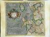
Westmorlandia, Lancastria, Cestria, Caernarvan, Denbigh, Flint, Merionidh, Montgomery, Salopia cum insulis Mania et Anglesey
1 Karte : Kupferdruck ; 34 x 40 cm Mercator; Hondius Henricus Hondius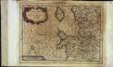
Westmorlandia, Lancastria, Cestria, Caernarvan, Denbigh, Flint, Merionidh, Montgomery, Salopia cum insulis Mania, et Anglesey
1 Karte : Kupferdruck ; 17 x 24 cm Mercator Cloppenburgh
Westmorlandia, Lancastria, Cestria, Caernarvan, Denbigh, Flint, Merionidh, Montgomery, Salopia cum insulis Mania et Anglesey
1 Karte : Kupferdruck ; 34 x 40 cm Mercator; Hondius Jodocus Hondius
England & Wales, northern section.
1 : 633600 John Bartholomew & Co.
Scotland I.
1 : 765000 Society for the Diffusion of Useful Knowledge (Great Britain)
Scotland 1.
1 : 760320 Letts, Son & Co.
Ireland 2.
1 : 760320 Letts, Son & Co.
Northumbria, Cumberlandia, Et Dunelmensis Episcopatus. [Karte], in: Atlas, sive, Cosmographicae meditationes de fabrica mundi et fabricati figura, S. 110.
1 Karte aus Atlas Mercator, Gerhard
Northumbria, Cumberlandia, Et Dunelmensis Episcopatus. [Karte], in: Gerardi Mercatoris Atlas, sive, Cosmographicae meditationes de fabrica mundi et fabricati figura, S. 112.
1 Karte aus Atlas Mercator, Gerhard Montanus, Petrus
Watershed map England, Wales 3.
1 : 760320 Letts, Son & Co.
Sheet 2 England, North West, uit: Maps of England & Wales : scale 4 miles to 1 inch / Ordnance Survey
1 : 253440 titelvariant: Maps of England and Wales; Annotatie: Titel op cassette; Met bladoverzicht op de achterzijde van de cassette; Annotatie geografische gegevens: Hoogtelijneninterval 200 ft Ordnance Survey, United Kingdom Southampton : Ordnance Survey Office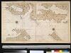
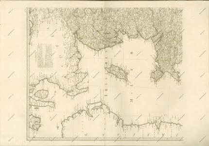
De Noord Oost kust van IJrlandt
Ireland Gerard van Keulen
GALLOVIDIA | vernacule | GALLOWAY.
Auct. Timoth: Pont. [Amsterdam : Joan Blaeu]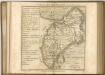

Cumbria; Vulgo Cumberland. [Karte], in: Theatrum orbis terrarum, sive, Atlas novus, Bd. 4, S. 490.
1 Karte aus Atlas Blaeu, Joan Blaeu, Willem Janszoon
Cumbria; Vulgo Cumberland. [Karte], in: Theatrum orbis terrarum, sive, Atlas novus, Bd. 4, S. 490.
1 Karte aus Atlas Blaeu, Joan Blaeu, Willem Janszoon
Cumbria; Vulgo Cumberland. [Karte], in: Le théâtre du monde, ou, Nouvel atlas contenant les chartes et descriptions de tous les païs de la terre, Bd. 4, S. 416.
1 Karte aus Atlas Blaeu, Willem Janszoon und Blaeu, Joan Blaeu, Willem Janszoon